Showing posts with label tour. Show all posts

Saturday, July 21, 2007

Oregon Photography Tour: Wine Country to the Oregon Coast

Waking up in Roseburg, I was at a loss as to what to go photograph at dawn. I decided to sleep in and go wine tasting instead. I found a number of interesting wines, particularly at Abacela Winery. Eventually my focus returned to photography and I headed for the coast.

I reached the Oregon Coast near Bandon, in time to check a few viewpoints to find a good spot for sunset. The Face Rock Wayside provided a stirway for beach access, scenic rock offshore, and plenty of flat, wet sand on which to catch the sky's reflection.
This was my first sunset on the Oregon Coast, and it looked like there would be too much cloud cover and nothing happening. Then suddenly a hole started appearing, and I loaded up my gear, grabbed the tripod, and rushed down the stairway and onto the sand.

I caught some nice shots of the hole opening up in the clouds. I believe the rock to the left is referred to as "wizard hat."


However before coming down to the beach I had moved things around between a backpack and my fanny pack. I was in such a hurry that somehow I ended up on the beach with no filters. I should have used a graduated neutral density filter for most of my shots, but using a tripod and brackeint exposures I was able to use HDR processing and have the results turn out OK. That was fortunate, because it ended up being one of my favorite sunsets of the trip!

Here are a few of my other shots from the Bandon area.


Friday, July 20, 2007

Oregon Photography Tour: Crater Lake and Rogue River Waterfalls

After a stop in the Klamath Marsh to catch sunset, I arrived in the Crater Lake area late at night and camped by Diamond Lake. Dawn could bring an excellent view of Mt. Thielsen across the lake. Dawn actually arrived late and gray, so I caught up on some much-needed sleep.

My first few stops along the road circling Crater Lake's caldera were gray and very windy, but by the time I reached the visitor center, the clouds had broken somewhat and I could see that Crater Lake's 1,943 feet deep waters take on the most amazing turquoise blue tones under the influence of a blue sky.

My most recent Internet access had revealed a weather forecast for partly cloudy skies on the Oregon Coast with a fair amount of sun for the next few days, so I headed down Highway 138 along the Rogue River. I stopped at a visitor center near Diamond Lake and determined that I could stop at several waterfalls along the way. I'd simply see how far I could get by nightfall.

One of my stops was Whitehorse Falls, a small cascade into a punchbowl plunge pool.

Another stop was Tokatee Falls on the Rogue River, a dramatic three stage plunge over substantial basalt columns.

In the narrow canyon above Tokatee Falls, this fallen log was resisting the full force of the river. I used a polarizing filter to cut light and slow the shutter speed so the shot would show the motion.

I continued down to Roseburg for dinner and a motel.

Thursday, July 19, 2007

Oregon Photography Tour: Fossil Lake Sand Dunes

After a night in a campground near the Painted Hills, with rain still forecast for the Oregon Coast, I set my sights for a large area on my Oregon map marked "sand dunes" out by the dry Fossil Lake, near Fort Rock and the town of Christmas Valley. What could be a safer place, I thought, than sand dunes near a dry lake, for a photographer spending a rainy week in Oregon?

Although the woman in the BLM office I visited to get maps said that she had never heard of people visiting the dunes to hike and take pictures (why do we ignore warning signs like that until we remember them later with 20/20 hindsight?), the dunes appeared to be oriented east to west, so I envisioned a sea of dunes that would be warmly lit by the sun at dusk and dawn.

It was going to be a 3-4 hour drive, so partway into the trip to stretch my legs I stopped at Newberry National Volcanic Monument in the Deschutes National Forest. One of the attractions there is the Lava River Cave, a lava tube which extends over a mile underground. Upon reaching one long, straight section, I tried some 30 second exposures. I determined that the gas lanterns rented by the entrance booth were a bit too bright, so I carried a flashlight (red end, white light shining on the floor) and triggered my camera flash multiple timestowards the walls as I rushed out 15 seconds and and then back for 15 seconds.

Having distracted myself from the long drive, I continued on towards the dunes. The drive seemed endless. Although I had a detailed BLM map and the road out to the dunes had been designated a "Scenic Byway" by the State of Oregon, The turns didn't seem to match my maps and the Scenic Byway was very poorly marked.

When I finally arrived at the primitive campground by the dunes, there was a group of maybe a dozen children riding around on tiny ATVs. It gave me the impression of a sort of miniature version of Mad Max. The parents were sitting by their pickup trucks drinking beers and watching approvingly.


Unfortunately the nearby dunes were sparse and widely spaced, overrun with ATV tracks, not particularly photogenic. I hiked out onto the dunes for a variety of sand pattern shots, but it didn't look good for dawn, so I decided to drive a couple of hours more to move on to Crater Lake.


I plotted the course on the map, and tooka a route that might get me to the Klamath Marsh for sunset.

Wednesday, July 18, 2007

Oregon Photography Tour: Mt. Hood to Painted Hills


On the morning of my second day, before leaving Mt. Hood, for old times' sake I had to have breakfast in Timberline Lodge. Timberline Lodge is a massive timber structure built as a Work Projects Administration (WPA) project to help employ people following the Great Depression. The lodge is filled with handmade furniture, rugs, and other items made by unskilled workers, under the guidance of skilled craftsmen. One of the most impressive parts of Timberline Lodge is the Great Room, featuring an octagonal, 3 hearth stone fireplace that rises several stories to the timber-framed roof above.

The breakfast was great, perhaps in part because my alternative had been to cook on a campstove on a wet table in the rain!

As a side note, if you've seen The Shining, you may recognize Timberline Lodge, as it was used for many of the exterior shots.

A trip to nearby Trillium Lake to catch Mt. Hood's reflection was fruitless due to cloud cover, so I got back on the road. After an overcast and rainy morning on Mt. Hood (picking ripe wild huckleberries was great, but not what I was in the state to do), I knew that I had to head further out towards Oregon's dry interior. I'd head first towards the Bend/Redmond area and let the weather steer me from there.

By Madras I could see threatening storm clouds hovering over the Cascades in the Mt. Jeferson to Bend/Mt. Bachelor area. I knew that the John Day Mountains reached heights in the 9000 foot range and I had never gotten out there while I lived in Oregon, so I aimed for the center of the state. I had seen a picture of the Painted Hills unit of John Day Fossil Beds, and it seemed to be a reachable goal for sunset.


I explored the hills under overcast skies for a while in late afternoon, then the clouds broke up as sunset appoached. I used a circular polarizer on my wide angle lens to help capture definition in the clouds, also bracketing exposures so I could use HDR processing

There wasn't much happening in the sky until I reached a ridge that gave me a great eastward view of the bare hills, with a massive thundercloud on the horizon behind them. The range of light from the brightest sun-lit clouds to the hills they were shadowing on the ground was enormous. I'd need a long exposure for the detail on the hills, a graduated neutral density filter to bring the sky closer to the hills in exposure, three exposure bracketing to allow for additional HDR processing if needed. I also used various combinations of a Tiffen Enhancing filter and a Cokin Sunset filter to help the clouds hold color for the shots I would send through HDR processing. As it turned out, the exposures were too long and the clouds were moving too fast to use a typical 3 shot HDR sequence. For this result I tried every combination of two shots to identify the best one, then further noise-reduced and color-corrected the HDR result in Photoshop Elements. To think that some people think that all landscape photographers do is show up and trip a shutter!

To further enhance the realism of my shots I often perform the best possible edit that I can muster on the best single exposure, then blend that in with my most realistic HDR result. The HDR version contributes shadow and highlight detail, while the single exposure helps enforce natural color tone and light intensities.

As the setting sun started painting the cloud orange and touching the broken clouds above, to the west the sun shot rays of orange between mountaintops and onto the underside of the clouds above there as well. Not wanting to miss either spectacle, I was running back and forth across the ridge alternating a couple of shots in each direction, capturing vertical and horizontal compositions while bracketing exposures and varying filters and combinations.

After a night in a campground near the Painted Hills, with rain still forecast for the Oregon Coast, I set my sights for a large area on my Oregon map marked "sand dunes" out by the dry Fossil Lake, near Fort Rock and the town of Christmas Valley. What could be a safer place, I thought, than sand dunes near a dry lake, for a photographer spending a rainy week in Oregon?

Tuesday, July 17, 2007

Oregon Photography Tour: Columbia Gorge

My trip started with the 600 mile drive to Portland, OR. With rain forecast for the next week, it didn't make sense to visit the Hoh Rain Forest and the beaches on the Olympic Peninsula in Washington. Having lived in Portland for 3 years in the 1980s, I knew that if I set mysights inland towards the dry Eastern side of the Cascades, I'd probably be able to avoid the worst of the rain.

The Columbia River Gorge was a logical way to head out of town, but it was raining and even having brought a giant golf umbrella and towel for frequent drying, most of my shots have some degree of water drops on the lense. The drizzle stopped briefly during my hike into Oneonta Gorge, so I was able to capture this shot of Oneonta Falls.


My first night out of Portland, after a dinner stop at the Full Sail Brewery in the town of Hood River, I headed towards the rian shadow of Mt. Hood. I still had a Forest Service map from when I lived in Portland years ago, and I tried to find a campsite that would have a sunset and sunrise view of the mountain.

This site, "Clouds Rest" had a promising name, and while it seemed to take foreever to reach up a decaying dirt road, my effort was rewarded with this sunset view of the breaking storm, over a sea of wildflowers.


It was raining and gray when I woke up, so it was fortunate that I made it to the campsite in time for sunset!

I heard a couple of days later that the Washington coast received record rain on the days that I had planned to visit, so having the flexibility to head for a drier part of Oregon really paid off!

Tuesday, September 12, 2006

Western States Photography Tour: Grand Teton National Park

Fishermen try the Snake River at Schwabacher's Landing.

The view from Signal Mountain in Grand Teton National Park, Wyoming.

I arrived before dawn at the Oxbow Bend viewpoint in Grand Teton National Park. A number of cars were stopped to watch a moose browsing on the side of the road. I pulled over across from him but stayed in the car, as he was not far away. Then he decided that the bushes looked much better on my side fo the road, and he crossed right in front of my parked car! He proceeded to feed on the bushes next to my passenger side window. He looked up briefly as I rolled down the window, then continued on with his business.

After a while he worked his way down towards the Snake River, oining his mate there. I was able to position myself downriver to get the Tetons in the background, just as the day's first light was reaching them.

This is the standard view from the vista point. Not bad, but compare this the following shot, taken from just down the slope!

Getting here requires climbing over the viewpoint retaining wall, and scrambling down a steep path to a small clearing in the trees about 50 feet below the viewpoint. Working a little harder to get just the right angle, you get much more of the river in.

I blew it on the camera settings here, leaving the ISO at 800, which I had used in pre-dawn light. I set the aperture correctly at f/22 for depth of field and the shutter speed ended up being 1/80th sec. Unfortunately there was way too much noise in this shot to have it ever make a good enlargement. This copy of the file is fine since I reduced the resolution about 9X (3x in the vertical and horizontal directions).

If there's another thing that seems a bit different in this view, I rotated the camera to level the plains below the mountains. There are enough off-vertical trees in the foreground to make it plausible, but to me the mountains getting smaller towards the real vanishing point off the left side of the picture seem to provide enough visual clues to give it away, and make the orientation not quite feel right.

The Mormon Row barns are another popular place for dawn shots at Grand Teton National Park.

Friday, September 08, 2006

Western States Photography Tour: Yellowstone Geyser Basins


I didn’t know it when I went to sleep, but I wake up to find myself parked almost on top of the Idaho-Utah border. The highway patrolmen from both states use this turnout to turn around.. I awake to see one coming at me, and as I crawl into the driver’s seat, I’m relieved to see him make a U-turn and go back the way he came.

Today I’ll explore Yellowstone. This will be my fourth time in the park, but my first time visiting alone.

I stop in West Yellowstone for the essentials… food, fishing license, and to check whether or not I can get a wi-fi connection. Everywhere I check seems to be dominated by a local service provider that asks for an exorbitant rate. West Yellowstone is a quirky little tourist town. It has what you’d expect… lots of tourist gift shops, a selection of motels, all mostly in older buildings. There’s also an Imax theater, some large and somewhat garish hotels, and a wolf and grizzly “discovery center”.

Eager to get into my first real shooting day, I leave town as fast as I can complete my errands and enter the park. With a low speed limit (to minimize collisions with animals, which still occur frequently) getting around the park is never fast, but the drivers are even slower so you just ahve to enjoy the scenery along with them. A few miles into the park we hit the first traffic jam. These are frequent in the park, and they`re a useful way to find wildlife. You just have to find a safe place to pull over along htese narrow roads, and watch for cars swerving to get around the ones that don`t get far enough off of the narrow road. It`s a circus, albeit a dangerous one. Yellowstone`s roads are extremely narrow, so you have to hope that the RVs have taken the advice to fold in their large trailer-towing mirrors so you wonn`t get knocked off your feet!

This "wildlife jam" is caused by a herd of elk. Most people are marvelling at the herd of cows, and don`t even notice the massive bull lying down a few dozen yards away. One tourist does, and creeps forward with his camera to get a shot, testing the 25 yard limit that the park sets for wildlife encounters. There`s a longer minimum distance required for bears, for those of us who really need more common sense I suppose. The rest of us are watching this guy, who`s wearing a bright red "charge at me" jacket on, and we`re wondering just how good at judging 25 yards the 1000 pound bull elk might be. We`re also curious about how many more yards the guy would get before the elk caught up with him if he got annoyed by this tiny, bright red carnivore who appeared to be stalking him. Poorly. The tourist survived his unwittingly death-defying stunt, and I got back on the road with a few decent shots.

The light isn`t great, it`s a bright, hazy overcast, but the forecast doesn`t call for much change and there are a ton of places I want to co see over the coming weeks, so I decide to hit the geyser basins today and see what I can get.

The geyser basins have boardwalks to enable people to get around across the hot, wet muddy soil, so it`s best to shoot in the early morning before you have tons of people in your shots and while you can use a tripod before the boadwalks start shuddering from the passing onlookers. I`m not quite early enough. Some of the geysers look more blue or green under a blue sky, but I don`t have that luxury either. I take quick laps of the boardwalks, snapping shots as I go.

The day is nearly over by the time I reach Old Faithful. I`m hoping for a nice sunset, but the skies stay mostly gray. Then it erupts early and un-faithfully while I`m checking the day`s shots in the car, so I have to wait another hour to show up very early for the next expected eruption. By the time I catch it, light gray spray against gray skies, it`s time to go find a campsite. I set my sights on the the campground near Norris Geyser Basin, which should be a good spot for dawn shots.

Thursday, September 07, 2006

Western States Photography Tour: Across Nevada - A Twisted Tale


"Saigon... shit; I'm still only in Saigon... Every time I think I'm gonna wake up back in the jungle. When I was home after my first tour, it was worse. I'd wake up and there'd be nothing. I hardly said a word to my wife, until I said "yes" to a divorce. When I was here, I wanted to be there; when I was there, all I could think of was getting back into the jungle. I'm here a week now... waiting for a mission... getting softer; every minute I stay in this room, I get weaker, and every minute Charlie squats in the bush, he gets stronger. Each time I looked around, the walls moved in a little tighter."
- Martin Sheen as U.S. Special Forces Captain Willard in Apocalypse Now

Life has a way of sneaking up on you. Job, house, bills, cars, insurance, investments, spouse, anniversaries, vacations, children, birthdays, education, sports, cell phones, email. Complexity tends to increase as the days, weeks, months and years pass. You do what you need to do to get everything done. You set goals, a new car, a second house, and often achieving your goals adds to the pace of your life. The overhead of managing your cumulative belongings, relationships and commitments tends to grow.

In spite of careful planning and steady progress towards your goals, at some point you may sense a subtle disconnect between getting what you want, and wanting what you get. You may notice the gradual erosion of the activities you engaged in and the traditions you practiced, including the ones that contributed to making you who you are, and the ones that soothed your soul.

Every once in a while you have the opportunity to step back, to reassess your goals, your priorities, and the incremental and cumulative effect that they have on your life. You may decide on a change, or some kinds of change may come at you with little warning. Change can be difficult, it can be stressful, but it can also provide the opportunity to adjust the things that you can control - your career, your residence, what you do with your free time - to restore balance. In fact, who you spend time with, including your spouse, is one of the choices you make that can be changed.

Like Captain Willard, I said yes to a divorce. I dream of waking up in a jungle. The temperate jungle of the California redwood forest or the granite towers of Yosemite. The stone jungle of Utah's slot canyons. The intricately layered and wind-carved sandstone of Arizona's buttes and mesas. The blazing aspen of Colorado's high country. When I'm here, I want to be there.

Nevada... shit; I'm still only in Nevada.

Don't get me wrong; I like Nevada. There are some truly beautiful sites in Nevada, but I wouldn't be visiting those on this day. Crossing Nevada can be an exercise, in concentration, in stamina, in your ability to absorb coffee. My crossing consisted of boredom, sparse radio coverage with stations in unfamiliar formats (country, evangelical), and the occassional shock of seeing a tree. Sometimes a live one! It was in this waking stupor that I approached the exit for Deeth, which vaguely struck me as eerily similar to "Death", perhaps spoken in an ancient Celtic dialect.

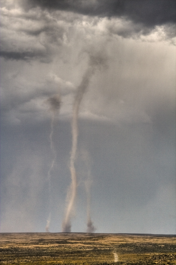
As I scanned the horizon to the north, perhaps scanning for my first tree in over an hour, I could make out a small cloud of dust on a hillside on the horizon. It resembled a column of smoke froma fire... no, perhaps a truck or farm equipment disturbing the dry soil. Over time if grew in size, and I could see by it rotation that it was a "dust devil", a large one. It was growing in size, and another cloud of dust appeared nearby, so I accepted Death's exit and pulled off to watch. The dust in the main column was reaching skyward toward the thunderstorm above, now resembling a true tornado. I was happy not to be in Kansas, where I might actually have something to worry about.

Smaller, tighter columns danced a few hundred yards away. It was still a bit unreal, but it was definitely getting downright interesting. I did what needed to be done: grabbed my camera, snapped my tripod open and locked the legs, clicked the camera in and started shooting. The funnels were highly unstable, appearing in places for a few short minutes, then starting up elsewhere and repeating the process. I counted as many as seven distinct areas where tornadoes were being spawned, with as many as five reaching the ground at any given time.

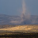
The front edge of this system was about a mile north of the highway, but it was moving south, in my direction. The leading edge of the rain started to arrive. Things could get too interesting in a hurry. One of those funnels could pop into existence over my head. I did what I could with f-stops and shutter speeds in the dim light, until the wind started howling and debris and rain was flying horizontally past. I could go one more exit to the west and watch this mess from the comfort and safety of my vehicle. I stuffed the camera gear into the front seat just before the deluge hit. I crossed the overpass and accelerated down the ramp, wondering at what point a vehicle starts to develop lift. I left Death behind as fast as I could and pulled off at the next overpass, a mile ro two down the road. I had driven out from under the rain. The funnel clouds were no longer clearly visible in the wall of water now coming down, but there was a large mass of dust mixed in the air that still marked their passing. I had no problems staying awake for the next hour or two, and I had already kicked off my multi-week shooting spree in a very unique way. It seemed to bode well for the trip to come.

Tuesday, August 22, 2006

Planning my western states tour

In September after spending Labor Day weekend in Yosemite I'll continue on to Yellowstone National Park, Grand Teton, Colorado National Monument, Canyonlands, Monument Valley, Antelope Canyon, Escalante-Grand Staircase National Monument, Bryce Canyon, Zion, and back via Death Valley.

I've established this blog to chronicle my adventures. Come along for the ride.