Showing posts with label Southern California. Show all posts

Sunday, April 03, 2016

California Spring Wildflower Sites, April: Antelope Valley

The Mojave Desert in April
Goldfields and California poppies mix with Joshua trees in Antelope Valley near Lancaster
One of my favorite photography road trips ever was a tour of California wildflower sites in the spring, including Antelope Valley and the California State Poppy Reserve, Carrizo Plain National Monument, Figueroa Mountain Recreation Area in the +Los Padres National Forest, and the area covered by the annual Ridgecrest Wildflower Festival in the Eastern Sierra. I posted on my blog at the time some of my favorite photos from the Antelope Valley, but I have a little more time now to take a second pass and show you more of what I saw.

I'm considering taking that route again this year, so reviewing past trips and refreshing my memory on what to stop in on and check can be productive. I've also looked up the wildflower report at the California State Poppy Reserve, which posted this update on Saturday, April 2:

"The season appears to have ended early, as last month's rains came too late to sustain the bloom that had barely started. The fields are mostly grasses now; only a handful of poppies are blooming alongside the trails. The beavertail cactus in front of the visitor center is blooming, which usually happens after the season has ended- a sign that an early summer is on the way."

An early start to summer should not be entirely unexpected, given the record El Nino heat in the Pacific Ocean driving our weather pattern in recent months. It's a shame though that it didn't bring enough rain at the right time to deliver a bumper crop of wildflowers in the Antelope Valley. The Antelope Valley is large though, and there may be dispersed pockets where enough rain fell, perhaps with a northern exposure to minimize drying during the gap in winter storms in February. Much of the area is in the Mojave Desert ecosystem, where Joshua trees serve as gerat subjects, with or without wildflowers.

In any case, many other areas of Southern California desert are blooming with normal to above normal intensity, so if I decide to take the trip, the conditions in the Antelope Valley won't make or break the outcome.

So while I have my photos handy, here are a few more photos from the Antelope Valley area on that prior trip, and I'll sprinkle a few across my various social media accounts as well.


The Antelope Valley California Poppy Reserve often starts its wildflower reports in mid-March to keep visitors updated on the conditions as they peak at some point through April. The area celebrates the annual bloom at the California Poppy Festival.  This year the 25th California Poppy Festival will be held April 16-17, 2016.

For more information, I cover the Antelope Valley California State Poppy Reserve, and other sites to visit on an April California wildflower tour, on page 184 of my new 320-page guidebook, "Photographing California Vol. 2 - South (shown to the right).

Road to Nowhere

Friday, April 01, 2016

California Wildflowers in April: Figueroa Mountain Road

Sunset from Figueroa Mountain Road
Are you looking for a place to find wildflowers along California's Central Coast? Figueroa Mountain can be a great place to see wildflowers when the timing is right. Helen Tarbet of the Los Padres National Forest sent out her first wildflower update of 2016 to email subscribers on March 18. She reports that "California poppies are blooming throughout the mountain" and "Other wildflowers to look for as you continue your uphill climb include, buttercups, goldfields, coreopsis, shooting stars, ceanothus, California poppies, Mexican elderberry, blue dicks, fillaree, royal lupine, lomatium, fiddlenecks, beautiful pink prickly phlox on the serpentine rock formation on the right and lovely orange wall flowers just beyond that. Also, you will see strikingly beautiful Catalina mariposa lilies in the open grassy fields and wild canyon peas in some shaded areas. At Vista Point (large gravel turnout about 11.4 miles from the bottom), exquisite chocolate lilies are in bloom..."

The variety along this road can be stunning. I hope to get back down there next week, but in the meantime, here's my description of Figueroa Mountain Road Recreation Area on page 218 of my Photographing California - South guidebook, illustrated with a few extra photos:
---

Figueroa Mountain Recreation Area, Los Padres National Forest 

Home to an annual wildflower bloom each spring, Figueroa Mountain provides a variety of species at various elevations, diversifying your opportunities and extending the wildflower season. The U.S. Forest Service often provides updates on the timing and progress of the wildflowers as they emerge in the February through April time frame, so if you have the opportunity, check their Web site for current conditions.

Photo advice: A selection of lenses will help you capture a variety of perspectives on the flowers. California poppies are one of the most common species of wildflower here, and they don’t open until they have warmed up in the sun, so it’s not necessary to rush up here for sunrise.

Getting there: From US-101 take CA-154 East, San Marcos Pass Road, 3.0 miles, turn left on Figueroa Mountain Road.

This is a narrow mountain road and your drive on it may take you 15 miles or more and increase in elevation 3000 feet. It is not recommended for large vehicles or trailers.

Time required: You’ll probably need 2 - 3 hours or more to navigate the road and have some time for photography.

Nearby location: Also in the spring, the oak-laden hills and pastures in the first mile or two of Figueroa Mountain Road may offer wildflowers such as wild mustard.
---
Lower Figueroa Mountain Road
After enjoying the wildflowers, consider exploring the town of Los Olivos and the wineries of the Santa Ynez Valley.

Saturday, March 12, 2016

Death Valley "Super Bloom" 2016: Best Wildflower Sites

Lower Warm Spring Canyon Road from miles 1 to 3 had declined slightly... to this! Still better than a "normal" year.

Last week I repeated and expanded the complete south to north traverse of Death Valley National Park that I had scouted in February.  How were the wildflowers holding up?  What were the best locations?  The Park has been issuing detailed reports, so let's use the March 2 and February 24 reports as a baseline, and I'll illustrate current conditions with my photos.
-----

Mile Marker 42, Badwater Road
March 2, 2016

The bloom is definitely moving north and higher in altitude. Although there are still expansive fields of Desert Gold (Geraea canescens) along the Badwater Road, as well as carpets of Sand Verbena (Abronia villosa) from Mile Marker 42 to the end of the road, many of the other flowers in this area are past their peak.

My pick of the week is Highway 190. Look for the cheerful Easter egg colors of bright yellow Golden Evening Primrose (Camissonia brevipes) and purple Notchleaf Phacelia (Phacelia crenulata) from Furnace Creek to the East Park Entrance. There are pink carpets of Purple Mat (Nama demissum) in some sections. (I think this flower was misnamed!) The ethereal, floating blossoms of Gravel Ghost (Atrichoseris platyphylla) are growing thicker in this area than I've ever seen them before. Northwest of the Visitor Center, you will find the expansive fields of Desert Gold that Death Valley is famous for. All along the road, get out and look closer for more variety.

Beatty Cutoff
A nice little loop drive is to go up the Beatty Cutoff Road and down Mud Canyon, then back to Furnace Creek along Highway 190. Mud Canyon is looking fantastic, but the flowers are growing so thick there that there is nowhere to pull over. Use the wide shoulders on the Beatty Cutoff and wander a wash to look for variety.

You will find Phacelia, Golden Evening Primrose, Mohavea (Mohavea breviflora), Acton Encelia (Encelia actoni), and Broad-Flowered Gilia (Gilia latiflora) on the Scotty's Castle Road. Although there are a few flowers on the approaches to Towne Pass and in the Panamint Valley, those areas are not yet worth a special trip. If you have a high clearance vehicle, do a little botanizing in the mid-elevations of the Greenwater Valley to increase your species count. There are not a lot of flowers blooming here yet, but there are a lot of different species, flowers you will not find in the lower elevations.

Hole in the Wall (4WD road)
Best backcountry dirt road drives this week would be the Hole in the Wall Road and Echo Canyon Road. Color and diversity in both these places is fantastic. Titus Canyon has some Paintbrush (Castilleja augustifolia) and Lupine (Lupinus sp.) in the mid-elevations, and flowers are blooming in the lower reaches of the canyon, but it will still be a few weeks before the bloom really gets going here.
For hikers, Fall Canyon and Monarch Canyon are good bets.
Happy flower hunting!

Furnace Creek Wash
February 24, 2016

The bloom is moving North! Check out the great color combo of Golden Evening Primrose (Camissonia brevipes) and Notchleaf Phacelia (Phacelia crenulata) decorating Furnace Creek Wash from the East Entrance to the Furnace Creek Inn. Keep your eyes open in that stretch for expanses of Purple Mat (Nama demissum) and the rounded humps of Turtleback (Psathyrotes ramosissima). Get out of your car and take a stroll in the wash, and you may be amazed at the diversity. I was able to identify over a dozen species in a ten minute walk!

Along Highway 190 north from the Visitor Center to the Scotty's Castle Road, fields of Desert Gold (Geraea canescens) are starting to fill in the blanks. One new hotspot is the Beatty Cut-Off Road. The diversity in some places is nothing short of amazing. Try walking a wash between Mile Markers 2 and 4 to taste a bit of that diversity.If you are traveling to Ubehebe Crater or the Racetrack, the Scotty's Castle Road is adorned with the same gold and purple color scheme as the Furnace Creek Wash. Although there is not enough yet to warrant a special trip, look for expanses of Mohavia (Mohavea breviflora) , blooming Acton Encelia (Encelia actoni), and Broad Flowered Gilia (Gilia latiflora) in this stretch. Phacelia and Golden Evening Primrose are also brightening up the approaches on both sides of Towne Pass.

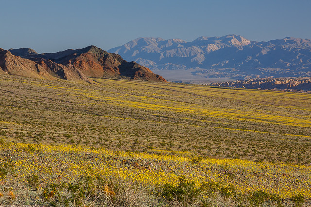
Badwater Road Mile Marker 30, looking back at 25
The Badwater Road is still the go-to destination for those huge expanses of endless flowers. The Brown-Eyed Evening Primroses (Camissonia claviformis) are starting to bolt due to hot temperatures and lack of rain, but the Desert Gold is still going strong, and the Gravel Ghost Atrichoseis platyphylla), Pebble Pincushion (Chaenactis carphoclinia), and Broad-Leaved Gilia (Aliciella latifolia) are just getting started. If you want those lower elevation flowers, though, you may want to come soon. I am amazed at how quickly the Phacelia and Desert Five Spot ( Erimalche rotundifolia) are working their way up their stems.

Harry Wade Road has some really nice things going on near the Amargosa River Crossing. As usual, get out of your car and walk a wash to see more varieties. Echo Canyon and Hole in the Wall should have some nice flowers. Check out the rock walls and see if you can find Death Valley Monkeyflower (Mimulus rupicola).

Greenwater Valley is REALLY green. Some flowers are starting to bloom there –I saw Fremont Phacelia (Phacelia Fremontii), Desert Dandelion (Malicothrix californica glabrata), Desert Gold Poppy (Eschscholtzia glyptosperma), Checker Fiddleneck (Amsinckia tessellate) , Blazing Star (Mentzelia sp.) and Globemallow ((Sphaeralcea ambigua) –but they are VERY few and far between still. In 2 weeks, this road will really pop.

Dante's View Road uphill from Greenwater Valley... in November!
For hikers, canyons are best for diversity. Fall Canyon is looking great, or try Willow and Sidewinder Canyons, or just wander up a likely wash.

Happy Flower Hunting!

-----

Overall the suggestions were great: accurate and with greater/longer relevance than most visitors may suspect.  By last week the intensity of the bloom had clearly declined down near Ashford Mill from my previous trip in February, but it was 1000X better than a normal year before, so if it had declined to "only" 900X as good, who cares? The opportunities were still tremendous, and well above average for Death Valley.

Alongside Badwater Road, nearly to Jubilee Pass
There's been a lot said about wind last Saturday night damaging the flowers, but again, I suspect that's relative to the mid-February conditions. We're just spoiled this year. I expect that there are plenty of wildflowers left compared to normal, and there will be plenty of exceptional pockets less affected by wind. Also, I bet that certain species such as sand verbena are designed to withstand wind (how the dunes they live in are formed). As I recall, the wind was coming from the south in the evening on Saturday, then from the north the next morning, so many canyons oriented east-west would be protected from that.

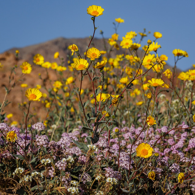
Spotted alongside CA-190 north of Furnace Creek
Anyone with a little experience with desert wildflowers and Death Valley should be able to successfully decode the puzzle and find the locations and species best under whatever conditions present themselves. Then again, with so many miles of wildflowers blooming, it's hard to go wrong, and you're bound to do well just driving through the areas highlighted on the Park's wildflower map. I found the scene to the right by the side of the road, simply driving from Furnace Creek to Beatty Junction.  So get out to Death Valley and find whatever compositions catch your eye and imagination!

For more photos, I've started a Death Valley 2016 album on my +Death Valley Workshops page, and a Death Valley iPhone 6S+ Photos album there as well.

Wednesday, February 24, 2016

The Almost Super Bloom in Death Valley

Reports are still coming in strong on the excellent wildflower bloom underway this month in Death Valley National Park. These photos are from my scouting trip through the park February 7-11.  
Desert Gold and Sand Verbena in Death Valley
Desert gold and sand verbena


As of February 9, some flowers were past prime, others were vigorous, others were just emerging.  Some rain fell a week later, which should extend the season for this year's already healthy crop.

Ashford Mill to Jubilee Pass
Looking from the Ashford Mill area toward Jubilee Pass
In spite of the hype in the media and on social media, the park is NOT calling it a "super bloom" yet, but in the recent YouTube video titled "Death Valley Exposed: Wildflowers - February 2016", park ranger Alan Van Valkenburg does imply that it has the potential, perhaps with additional rains: “If you get the chance to see a bloom in Death Valley, especially a super bloom, you should take the opportunity to see it because it could be a once in a lifetime opportunity.”

There was a less dense area of desert gold north of Furnace Creek, up to and through the Beatty Cutoff area. Most other areas were looking basically lifeless, even though they may have received a lot of rain. The timing of the rain may not have been early enough for the plants to be far along yet, and once they get going they do need additional rain to keep the growth going. Rain last week in mid-February might have helped extend the life of these areas, and the growth of others.

Overall the spring wildflowers in Death Valley are usually very sparse, and peak in March, so outside of the areas I just described, the season seemed normal: nothing much should be expected in early February. The initial bloom may or may not be followed by decent blooming elsewhere. We saw healthy growth in November in areas such as the narrow last portion of the Dantes Peak road, so we were expecting the adjacent Greenwater Valley to be going nuts when we returned in February. Instead, it looked even weaker than last year... not much going and much less promising than expected.

So in much of the park, as the initial strong bloom of desert gold fades, the situation may resemble a more normal year, where you can find wildflowers, but it requires some hunting and probably high clearance, if not 4WD.

Here are a few more photographs from my visit to supplement the ones I included in my recent trip report. I drove the park from Dumont Dunes all the way out the top at the town of Big Pine.


Desert gold extensive but thin looking north from the Salt Creek turnoff north of Furnace Creek


Not far from Ashford Mill, south of Badwater


The southern end of Harry Wade Road wasn't as productive as the north end and and the Ashford Mill area.  Many of the flowers were wilted from heat, and didn't look like they were going to last much longer, especially the brown-eyed primrose.


Fiats don't float!  Not in water, not in sand.
Unpaved roads in Death Valley are marked for high clearance or 4WD vehicles for a reason.


It's not all about the desert gold.  Look closely and you'll find dozens of species available.


Bear in mind, the park didn't just suddenly become only about wildflowers!


Miner's cabin

Monday, July 27, 2015

New California Landscape Photography Guidebook Coming Soon

Photographing California - South, landscape photography travel guidebook
Photographing California - South, my new landscape photography guidebook
I'm one step closer to being able to ship you a copy of my new guidebook to the best landscape photography locations in California, from Yosemite National Park south.  I received the first sample copy, express-shipped ahead of the boxes and boxes of copies which will ship to retailers.

In the next few days I'll set up a purchasing link for pre-orders and author-signed copies, so I've set up a mailing list with a sign-up form below, where you can opt in to hear about its availability:

Notify me when the book is available

* indicates required


California landscape photography guidebook by Jeff Sullivan

The book covers a lot of what you'd expect, including Yosemite National Park, Death Valley National Park, Joshua Tree National Park, Kings Canyon/Sequoia National Park, Channel Island National Park, Pinnacles National Park, Mojave National Preserve, Anza-Borrego Desert State Park, Devil's Postpile National Monument, and the California Coast from Santa Cruz to San Diego.  It includes many state parks and beaches, sites on land managed by the U.S. Forest Service, Bureau of Land Management, and National Natural Landmarks.  I weighted coverage by scenic and photographic value, so the Eastern Sierra gets separate chapters for the Mono Basin, Mammoth Lakes area, Bishop Area, and Lone Pine to Mojave.

Most of the locations covered can be reached easily by car or via a short walk, but also included are a few stunning destinations best reached using high clearance or 4WD vehicles, overnight backpacking, or horses.  In all, over 350 photos are provided to illustrate over 300 locations, and many site entries reference additional nearby areas worthy of additional exploration.

Mammoth Lakes chapter
The photographic potential of a site can vary by season and by time of day, so I advise readers on both seasonal timing and when the light is best.  Where there are special technical photographic considerations such as optimal focal lengths or filters to use, I describe those as well.  Seasonal considerations can include the angle of the sun, wildflowers, fall colors, peak waterfall flows and special events such as lunar rainbows. Somehow I packed this all into 320 pages!

The book is the latest volume in the publisher's series covering many Western states, and an ebook version will be available as well.  This project was a massive undertaking, taking twice as much time as I expected, about 5 years.  To complete the book I drove a distance roughly equivalent to halfway to the moon.  Death Valley alone warranted approximately 20 visits to explore new locations, even after having already visited the park that many times already over the prior 5 years as well.  I'm crazy about nature, landscapes and photography, so I'd do it over again in a heartbeat.  Completing this book was the experience of a lifetime!

California landscape photography guidebook by Jeff Sullivan
I'll recoup my travel expenses slowly and it may be years before I get anything extra to cover my time, but I keep the retail markup on the author-signed copies, so your direct purchases through me provide maximum support for this project.

If you prefer free shipping copies from an online book retailer, no problem, I'll have a link for ordering it through my "astore" there, and even the few dimes more in commission I'll receive from using that link will help greatly towards making this project viable (compared to ordering it directly there without my affiliate link).  You can also order it alongside other books in the series, once the listing for my book goes live.

I'm generally fairly shy and not really comfortable asking for things, but if you tell your photographer friends about this book, it you buy copies for birthday or Christmas gifts, or even just "Like", comment on, or share my social media posts to help spread the word on it, you'll be doing me a huge favor.  Thanks in advance for your support, in any form it might take!

California landscape photography guidebook by Jeff Sullivan
Based on the success of this book release, I'll decide whether to move right into another travel guide.  If I do, what would you like me to cover next, Nevada, the High Sierra, Wyoming or Montana?  Drill down in more detailed regional guides (Yosemite, Death Valley, Eastern Sierra)?  Something international, perhaps Patagonia or Iceland, or more developed travel destinations like Italy, Spain, Switzerland, Turkey?  Tell me in the comments.  If I can pick my next project now, I can set it up on  Kickstarter and use this first book as one of the rewards for your support on my next one.

Last but not least, thanks to everyone who cheered me along over the years, on Facebook, Twitter, Flickr, Instagram, Google+, 500px, YouTube, Vimeo, PInterestWordpress, Tumblr, and here on Blogger,  You kept me going on this long road (looong road).  Thanks also to my photography workshop customers, you kept food on the table, a camera in my bag, a computer on my desk, and my car in working order.  I have a few more Bodie night photography and interior access dates left in 2015, and as the book sales go into autopilot as retailers pick it up, I hope to resume the Yosemite, Death Valley and Eastern Sierra workshops that I've offered in the past, and add dates to my calendar shortly.

Wednesday, April 06, 2011

Antelope Valley Wildflower Report 2011


Antelope Valley Poppy, originally uploaded by Jeffrey Sullivan.

Like many place in California the wildflowers aren't as prolific as last year, but it's far form a poor season. You'll have to hunt for the best patches, but here's a sampling of what I found in the Antelope Valley area over the past couple of days.


Carrizo Plain Wildflowers Spring 2011


Tidy Tips at Sunrise, originally uploaded by Jeffrey Sullivan.

Here's a quick photographic tour of conditions at Carrizo Plain a couple of days ago. Opinions on this year's bloom range from normal to "past peak" to "slow and coming," and all three may be true in places. Whatever the high level summary you want to assign, you'll work harder to find less compared to last year, but you can still find some great patches to work with if you put in the time and miles.


Note the new sharing options that will allow you to share this report with your friends on Facebook, etc!

Shell Creek Road Wildflowers


Shell Creek Road, originally uploaded by Jeffrey Sullivan.

Here's a quick update on wildflowers this year. The ample rains we've received can be critical for wildflower growth, but in too much quantity or at the wrong times, they also result in a bumper crop of grass, which seems to crowd out the wildflowers. Let's give it a couple more weeks before we declare this a normal to weak year in this area. For now the color tends to be sporadic and modest, favoring photography of a plant or bloom instead of landscape-scope carpets.