Showing posts with label road trip. Show all posts

Friday, September 28, 2018

Oregon Coast Photography Tour September 2018

Oregon Coast dunes at sunset, September 2018.
I just completed a 2000-mile trip to revisit some of my favorite places in Oregon. Although I lived in Oregon for years in the 1980s and revisited a lot in the mid to late 2000s, I hadn't been to some of these places in years. Even with 2+ weeks it wasn't enough time, so I'll just have to go back soon!

I don't know when I'll get around to uploading all of my photos from my recent Oregon Coast photography tour, but here are a few images that I've uploaded so far.

What's your favorite place along the Oregon Coast?

Bandon Sunset Panorama

Twilight Hunt

Oregon Coast Sunset

Samuel H. Boardman Scenic Corridor, Oregon

Tangerine Sunset on the Oregon Coast

Monday, May 02, 2016

April Road Trip to Death Valley

Natural Bridge
You may have noticed that I'm obsessed with death. Death Valley National Park, that is! I grew up in New England, just about as far from the desert as you can get in America, so in my current quest to explore the largest national park in the Lower 48 States, I must be making up for lost time. 

Mesquite Flat Dunes
Fortunately, currently living in the nearby Eastern Sierra region, I'm only 3-4 hours from a couple of park entrances, so I can indulge in my desert yearnings frequently. I usually visit once or twice in the Thanksgiving to New Year's Day time period, then again in February and March as the wildflowers start to bloom. But as spring continues and Death Valley starts to really warm up, I like looking for storms and bouts of cooler weather, in case I can slip one or two more visits in before it gets too hot. 

In April 2016 I could see a storm front approaching in the weather forecast. Daytime high temperatures would drop into the 80s.  I'm currently working on a detailed photographer's travel guide to the park to be offered in the +SNAPP Guides app, so I threw my camera and camping gear into the car, and headed to the park with a list of the sites I wanted to explore or revisit next.

I hiked to a natural bridge, and enjoyed great views with sunlight streaming through clouds. I explored stone-walled buildings at an old mining town site, and found wildflowers thriving at higher elevations than on past visits this year.

I met a Subaru coming out the wrong way from Titus Canyon, apparently deciding that "high clearance" meant higher then they had. The worst part of the road is about halfway through the 24-mile loop, so drivers that wait that long have a lot of wrong-way driving to do. Sometimes they're in a hurry to get out, so they come flying around blind turns!

On the edge of a canyon, two jets saw me with my camera, so they took two passes each direction up the canyon, turning and shooting up sharply right in front of me, so I was able to get some great shots. They were very fast, very close, and very loud!

In Salt Creek, the water was slightly higher than normal, so the pupfish were exploring down to the parking lot, feeding in the flooded margins before low water forced them back into their normal cramped habitat space. Normally they're a little skittish, but their quest for food prevailed, so when I held my iPhone out over the water, one came over and posed for a portrait.

On one evening, I caught a sandstorm over Mesquite Flat Dunes, back-lit with golden sunlight by the setting sun.

On the way home, sunset light was lighting up rain showers at Mono Lake. It was an eventful and productive trip. I can't wait to return!  In the meantime, I've uploaded the latest batch of photos to the Death Valley 2016 photo album on my +Death Valley Workshops page on Google+.

If you might like to join me in Death Valley sometime, my spring 2016 workshops are done for the season, but I can add a session in mid-December if there's sufficient interest: Death Valley Photography Workshops.

Jellyfish Cloud
Sunset rain showers over Mono Lake

Tuesday, April 05, 2016

Shell Creek Road Wildflowers, Paso Robles


Shell Creek Road is a rural road running north – south between CA – 58 and CA – 46, passing pastures and rolling hills that can feature wildflowers in late March through April. There are also agricultural fields which can have symmetric lines for photographs, as well as a large vineyard with both old and young vines. The old vines are probably the ones which yield the excellent the Shell Creek Vineyard reserve petite sirah produced by David Bruce Winery in the Santa Cruz Mountains.

Shell Creek Road can be a convenient detour to take when approaching Carrizo Plain National Monument from the north, or departing Carrizo Plain in the direction of Paso Robles. The wildflowers are more concentrated towards the southern 6 miles or so.

Directions

From Paso Robles at US-101, take CA-46 east 15.6 miles and turn right onto CA-41 West Centre street.  Go 2.8 miles and turn right onto Toby Way.  After 0.3 miles on Toby Way turn right onto San Juan Road.  After 4.5 miles turn right onto Shell Creek Road.  You’ll be on Shell Creek Road 10.7 miles, ending at CA-58.

To continue to Carrizo Plain National Monument, travel east on CA-58 24.2 miles, turn right on Soda Lake Road and travel 13.7 miles.

There's a creek at the north end of the road which can flow over the road after a heavy rain, and this can close the road. When I last visited, there was a car in the creek, just downstream of where it had washed off of the road. Don't underestimate how deep the water is, or how little force it might take to push your vehicle off the road!


For more information on the area, I cover Shell Creek Road on page 177 of my "Photographing California Vol. 2 South" landscape photography guidebook.

Thursday, March 31, 2016

Revelstoke: Heli-ski Capital of the World?

Revelstoke National Park, British Columbia, in September
When I passed through the picturesque town of Revelstoke, British Columbia in September, I know that it was a quaint little ski town, with world famous helicopter skiing opportunities in the surrounding mountain ranges. I had grown up seeing the Monshees and Selkirks highlighted in the ski movies by Warren Miller (now +Warren Miller Entertainment), so it was great to be seeing the place in person, a bit of a pilgrimage for a powder skier. I was pleased to find that the town hadn't been overrun with condominiums and other development, like so many other North American ski towns. It's a real town, with actual inhabitants. What a concept!

Upon arrival in town, it was nearly sunset, so I found a pond for reflections. There wasn't much beyond the sky and reflection for a subject however, so I moved to a view where I could see one of the surrounding peaks with the last light of the sun on it.

The hotel I was staying in had a lot of skiing images on the wall, so I walked around admiring them. As it turned out, it was the base for CMH, Canadian Mountain Holidays, one of the well known heli-skiing operations in town. I've skied all of my life, and I had avalanche training along with the 12-week Outdoor Emergency Care course given by the +American Red Cross when I was on the National Ski Patrol at +Squaw Valley Resort for a few years.  With ski season on the way, I was tempted to fill out a job application! Somehow I resisted the temptation. Maybe next year....

What I didn't know at the time was that my brother would be skiing in Revelstoke this winter. With the American dollar strong, he and his friends looked into dates and prices, and decided to go with +Selkirk Tangiers Heli Skiing.  I couldn't join them this time, but at least I know what I missed, via his +GoPro video from the trip:


I have to admit that I'm more than a little jealous... it's definitely a "bucket list" trip that I'd like to take sometime!

 The next day there was a dusting of snow on the surrounding mountains, but the storm was already breaking up, so it was a perfect day to head into adjacent Revelstoke National Park to enjoy the views. I was planning on heading in the general direction of Lake Louise and Banff, so I couldn't go on any long hikes.

 As it turned out, the scenery was spectacular as I headed east, and the weather kept the conditions interesting for photography, so it was a great day to be on the road. I passed a few national parks that I didn't have time to explore; I'll definitely have to allocate more time to enjoy the area on my next pass through.


#roadtrip #travel +Tourism British Columbia +Visit Canada

Saturday, January 02, 2016

Top 10 Favorite Travel and Landscape Photos from 2015

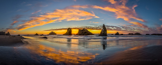
Bandon Sunset Reflection, Oregon Coast
Ansel Adams once stated that "Twelve significant photographs in any one year is a good crop."  Perhaps Ansel would be more efficient and productive today with digital photography, or perhaps he simply had a really high bar for what he considered "significant".  


I often produce a few dozen photos per year that I'm pleased with and collect into albums on Flickr, so reducing them down further, to something like an annual "Top 10", doesn't always reach the top of my "to do" list. But as the "Photographing California" book that I finished and released in 2015 starts to go into retail auto-pilot, I can take a moment to reflect on my past year of photographic adventures as I look towards 2016. 


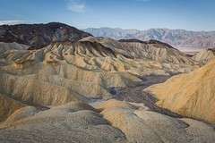
Great Light in Eroded Hills, Eastern Nevada
The photo above was captured early on in my 3500-mile "victory lap" road trip that I embarked on in September, as my book was about to ship to wholesalers and Amazon.com. I visited Mt. Shasta, Lassen Volcanic National Park, and Crater Lake National Park before turning west and heading for the coast. I arrived just in time for sunset. 

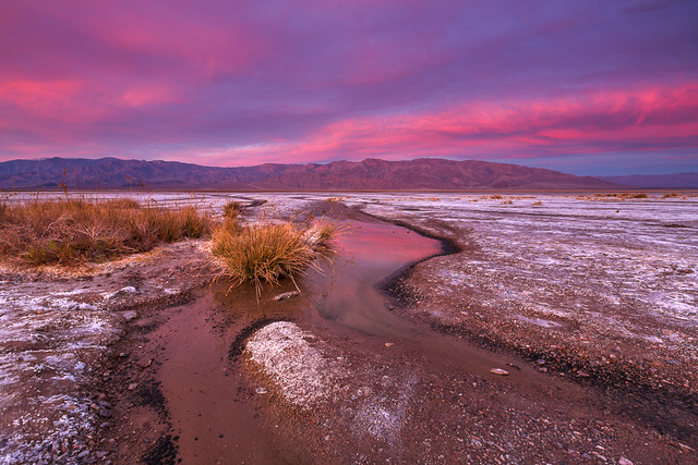
In March I took a quick trip across Nevada to scout for locations for possible Nevada photography workshops in 2016. I've been doing this for a few years now, but it takes a lot of experience to get to know a region, in detail, in a variety of season s and weather conditions. The photo to the right shows one of the sites that I really enjoyed for its geology and geometry.  Other sites in Nevada are good for wildflowers, dark, clear night skies, history (petroglyphs, mining areas and abandoned ranches), or cultural details. The state is huge though, and supporting resources such as gas, restaurants and lodging are spread out, so it'll pose some interesting challenges to cover efficiently and comfortably with a group. Access can also be complicated by weather and washouts on the often unpaved roads, so vehicles with appropriate all terrain tires and adequate ground clearance can also be a consideration.


A year wouldn't be complete for me without astrophotography, so in late April I headed out to the Mojave Desert in search of some photos of the Milky Way rising. In the case of the image below, I captured a sequence of 54 photos around 2 am to show the movement of the stars.


Milky Way Rising Behind Joshua Trees.
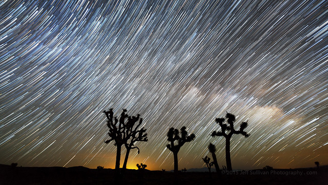
Milky Way Rising Behind Joshua Trees, Mojave Desert
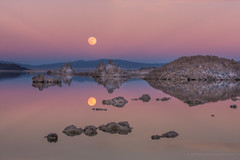
In June I still had the Milky Way on my mind, as I dropped by Mono Lake to capture a 360-degree panorama featuring the lake's tufa calcium carbonate rock formations under the arch of the Milky Way.

Mono-Lake-360-degree--panorama-tufa-Milky-Way-night-photography-jeff-sullivan
Mono Lake Milky Way Arch Panorama
By July we had a nice summer monsoon season of sporadic storms, not enough to end our drought in the Eastern Sierra, but storms are certainly a plus for landscape photography! In this case a shaft of golden hour sunlight struck a column of rain, producing a warm-tinted sunset rainbow.

Shaft of Water and Light
Shaft of Water and Light, Topaz Lake
Although there are so many stunning photography locations to cover in California I only included a handful of backpacking destinations in my book, I personally love backpacking, so I took the opportunity to visit the Golden Trout Wilderness in July. Little did I know that the remains of Hurricane Dolores would come ashore that night, creating "super historic" record July rainfall across much of Southern California. Fortunately there was a break in the rain on the following day, so I could head to the trailhead to dry out my gear before selecting my next adventure.

Muir Lake Morning Reflection
Muir Lake Morning Reflection, Golden Trout Wilderness
In August the big event for me is usually the Perseid meteor shower. Sometimes I like to maximize sky in my meteor shower photos, but in this case I decided to include an interesting Joshua tree. So back to the Mojave Desert I went.

Perseid Meteor Shower 2015
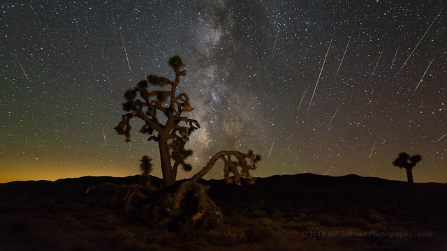
Perseid Meteor Shower and Milky Way over Joshua Tree, Mojave Desert
Another location that I visited during my whirlwind September road trip was Morraine Lake in Alberta's Banff National Park. I was fortunate to arrive right after the first snowfall of the year, and it was still snowing lightly as the last light of the day faded, so there weren't many people out in the cold to wander into this shot along the shoreline. I also picked up the more typical elevated view from a nearby knoll, showing the glacial blue color of the lake, on the following morning.

Morraine Lake, Jasper National Park
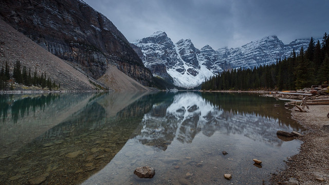
Morraine Lake, Banff National Park, Alberta, Canada
I captured a number of nice Bodie and Eastern Sierra fall colors images this year, but one of my favorites was this late, snowy fall colors shot from Conway Summit in early November. Many of the compositions I was capturing on this morning were a little too evenly lit, but for a moment a thin spot in the cloud cover had the lower portion of this line of trees brightly lit while the trees and hill in the ravine in the background fell into darker shadow. This highlighted the lower line of trees and gave the whole scene a more 3D feel to it.

Snowy Fall Aspen
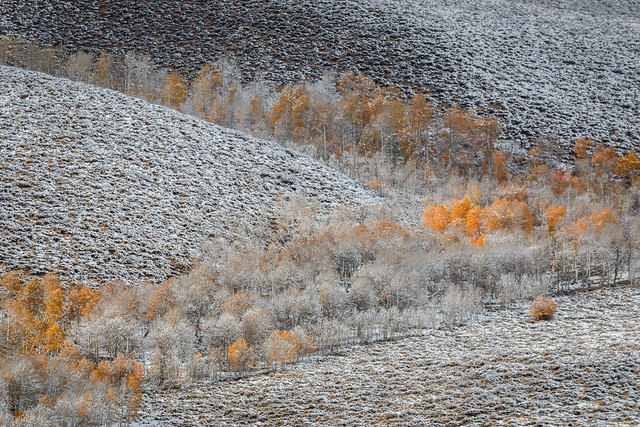
Snowy Fall Aspen, Early November in Mono County
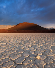
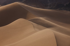
Later in November I headed to Death Valley to pursue some new locations for an upcoming detailed guide to the park that I'm writing, but one of my favorite images ended up being from the Mesquite Flat Dunes near Stovepipe Wells. I had other photos with arguably better light, but the photographers add scale and a nice point of interest. I've photographed these dunes a lot, but the combination of low angle sun and broken light passing through breaks in the clouds created some unique opportunities.


Stunning Light on the Dunes in Death Valley
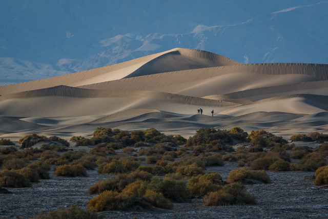
Exploring the Dunes in Death Valley, Mesquite Flat Sand Dunes
New 2015 Results from Past Years

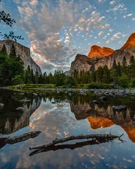
Valley View Calm Evening Reflection, Aug 2007
As I was working on the book I occasionally came across good photos from past years... when either I lacked the tools to complete a nice result, or I simply overlooked an image due to time constraints or simple oversight. Fortunately I can rediscover and rescue these old files on future visits to the folders that they're in. The one to the right was from Yosemite, way back in August 2007. It was captured on a Canon Digital Rebel XTi! A little adjustment in Lightroom 5, and voila! It's as good as new. I used it as the title page for my guidebook.

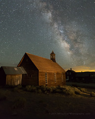
One of my more stunning finds was from an incredible sunset in Bodie during one of my workshops on June 29, 2013. Bodie was just outside of the area I was covering with my book, so post-processing photos from there hadn't been a priority. My loss then, and gain now! It was an unusually purple-tinted sunset, as confirmed across many photographers and cameras from various manufacturers.A few shots in the middle of the sunset's transformation had a wide variety of colors, ranging from orange-yellow to magenta-pink and blue to indigo shades, in addition to the base purple that dominated many adjacent shots.

Sunset Over Bodie Main Street
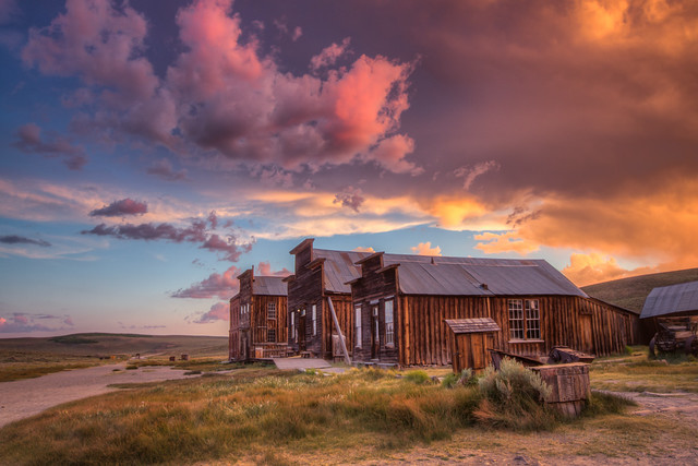
Sunset Over Bodie Main Street, June 2013
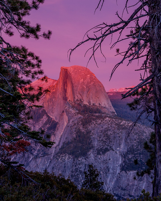
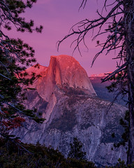
There was another surprising overlooked shot that I found in an old Yosemite folder from 2008. Covering Half Dome at sunset from Glacier Point, the Yosemite chapter had already gone through layout before I found it in February, but it's a nice addition to my Yosemite portfolio for future uses!

Sunset Alpenglow on Half Dome

Runner-up Images for 2015

I named my Top 10 for people who prefer the predictability and order of a preset and finite number, but I'll show a few of the other contenders for people who prefer not to be arbitrarily constrained.

This sunset shot is from the Cambridge Hills south of Yerington in Mason Valley, Nevada. I was looking for some old cars that were supposed to be in the area, but they were apparently either moved or stolen. The road had to serve as the subject and leading line, heading to that last bit of orange sunlight on a shaft of rain int he distance.

Storm Chasing in Nevada

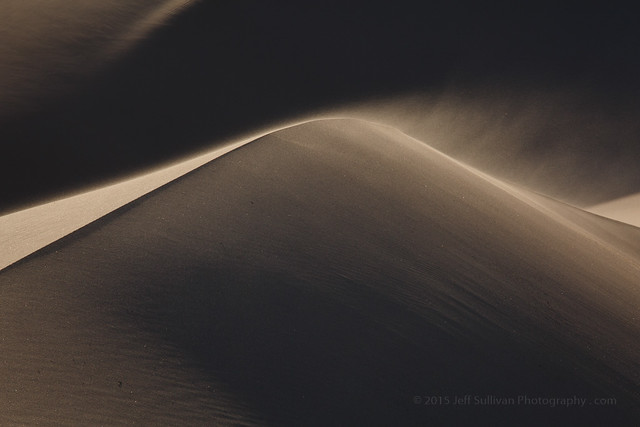
This dune shot was captured at 200mm to isolate the dune ridge and blowing sand from the dark background. I was hoping to see a desert tortoise or two in the area, but the burrows I found had cobwebs in their entrances.

Windy Day on the Dunes in Death Valley

At the bases of Death Valley's mountain ranges, on the edges of their alluvial fans of gravel and debris, you sometimes find small springs. In a landscape that only receives an average of 1.93" of rain per year, these are precious sources of water for nearby wildlife.  They are delicate places as well, with soft mud that will easily become severely trampled if hordes of visitors show up and love them to death.

Sunrise in Death Valley

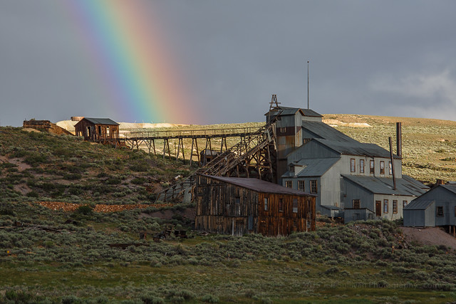
I spend a lot of time in Bodie, and occasionally I'm there for the evening break-up of afternoon thunderstorms. In this case I saw a rainbow forming over town, and I knew that if I shifted my camera position a couple of hundred yards, I could place the rainbow over the Standard Mill. These opportunities can change quickly, so I hopped into my car, and drove east to move the rainbow.

Rainbow over Standard Mill

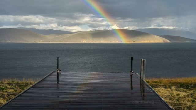
This rainbow and reflection shot was one of my favorite mobile phone images in 2015, and one of my first photos taken on an LG G4 smartphone that I was provided with as part of the #G4Preview program.

Wet Rainbow Reflection

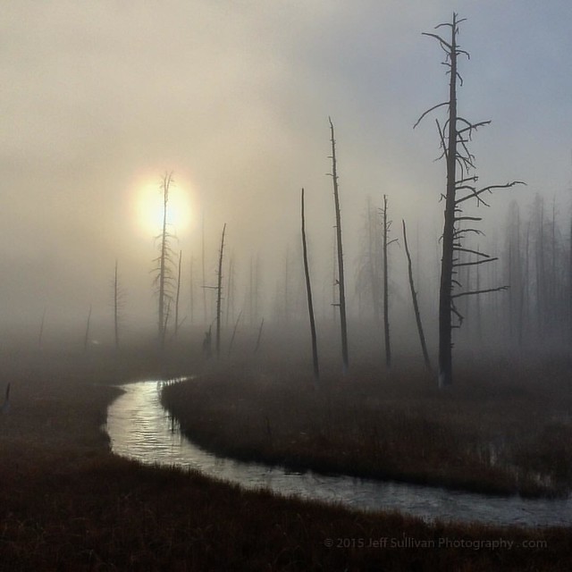
This sun shot captured through geyser basin fog in Yellowstone is another of my favorite mobile images, this one captured on my 2 year old iPhone 5S.  It won an +Instagram / iPhone assignment being conducted by Outdoor Photographer Magazine.

Sun and Trees in Yellowstone Fog

I have many more images that I considered for my favorite photos and moments of 2015, and I've collected over 50 of them in a 2015 Favorites album on Flickr: https://www.flickr.com/photos/jeffreysullivan/albums/72157651316649769

Favorite Photos from Prior Years

Here are some of my collections from prior years.  It has been a great decade of adventure, I can't wait to see what I can find to show you in the next 10!

2014 Favorites album on Flickr

2014 Favorites 

2013 Favorites album on Flickr 

2013 Favorites

2012 Favorites album on Flickr 

2012 Favorites

2011 Favorites album on Flickr
2011 Top 10 blog post


2011 Favorites

2010 Favorites album on Flickr 2010 Top 10 blog post

2010 Favorites

2009 Favorites album on Flickr
2009 Top 10 blog post


2009 Favorites

2008 Favorites album on Flickr 2008 Top 10 blog post

2008 Favorites

2007 Favorites album on Flickr 2007 Top 10 blog post

2007 Favorites

2006 Favorites album on Flickr 2006 Top 10 blog post

2006 Favorites


Friday, October 23, 2015

A Day in Grand Teton National Park, Wyoming

Lewis Falls,  Yellowstone National Park. 

Departing Yellowstone National Park to the south, you pass Lewis Falls on the Lewis River just below Lewis Lake.  There are a number of scenic stops that you can make along Jackson Lake, but campgrounds there were closed or full, so we headed towards the large Gros Ventre Campground down near the Jackson Hole Airport and the tiny town of Moose, Wyoming.  Fortunately Gros Ventre had room, and the cottonwoods were stunning in their yellow fall colors.

Smartphones are a great resource while you travel, whether looking up lodging and restaurants, using a map program to navigate, or Google Earth to look for unpaved roads to explore.  It's best for a smartphone's battery life not to keep it plugged in all the time, and to let it get pretty well discharged before charging it back up again.  There's no telling where your devices might be in the charge-discharge cycle when you stop, but when I'm not driving, I can top off my devices in a campground using a 10,000 MAh battery.  You don't expect to lose your vehicle as a power source, but on this trip I did, so it was good that I had an alternate power source to ensure that we'd have enough power to call for a tow truck!  

The LG G4 phone I was using for some photos on the trip has 32GB memory but, only 16GB after apps and OS, so it was at 1% remaining space when I took this.  The SanDisk memory stick charging here is also a Wireless Memory Stick that works over wifi, so I had it automatically back up all photos from the LG G4 as I took them.  I'd periodically delete a few photos from before the trip, since I was pretty sure that I had them at home, and they were backed up to the Wireless Stick anyway.  When I hit a hotel room every few days, I could plug the wireless stick in to my laptop like a standard USB memory.  (It could do that wirelessly in a campground as well, but I use laptops with 17" HD screens, which have short enough battery life to be more convenient to use when connected to power.)

Devices attended to, we could settle in for dinner and a glass of wine.  It was a clear day, so there was no need to rush out for sunset.  We had picked up a 2014 Larch Hills Marechal Foch Reserve, from the North Okanagan wine region in British Columbia, Canada.  I had never tasted a Marechal Foch before.  Now I have.  It had a very different flavor profile than more common red wines like cabernet or syrah.  It was more like Argentinian malbec meets "young wine" (think Beaujolais), with perhaps a trace of residual sugar.

The next morning we headed over to nearby Mormon Row and the popular Moulton Barn.  I forgot that we had passed some long, deep, muddy puddles in the road on our way to the campground the evening before, so when I came upon the first one, rather than stop and go around it seemed wiser to click on the 4WD and just power through, sheets of water and mud spraying out to the sides.

There were only a couple of people at the barn when we arrived, but it quickly got more crowded.  There wasn't anything exciting going on in the sky, so the scene of photographers was about as interesting a subject as anything.

The area just to the north of this is known as Antelope Flats, and true to its name, a buck antelope had a few girlfriends alongside the road.  It being close to mating season, at times he would spontaneously jump around and prance and dance, either to impress them or simply as an outlet for his excess energy.  If they noticed, they pretended to ignore him.
We went back for breakfast, packed up the campsite, and spent the day enjoying the changing light in Grand Teton National Park, as well as checking out the fall colors along nearby Forest Service and 4WD roads.  I wanted to drive by Jackson Hole Ski Resort and picture it with a coating of snow.  Maybe I'll return for some skiing in a few months.

Jackson Lake was nice and calm when we drove by, so there were some nice reflections of Mount Moran.  Oxbow Bend was calm as well, with the added bonus of bright yellow aspen reflecting in the still water of the oxbow.  I've encountered moose here on several occasions, and moose, elk and grizzly bears at Willow Flats just to the west, but this time people at the Oxbow Bend turnout were looking across the water for a moose they had seen over there.

Other animals were pretty much in their usual places.  Horses were feeding in a large field north of the historic Cunningham Cabin, and across the Jackson Hole Highway bison were feeding in their usual place on the Wolff Ranch.  Bison were also near the northern end of the Mormon Row barns.  In the evening, several bull elk near Teton Park Road south of Jenny Lake were bugling to warn potential challengers not to try to take their harem of cows.
There were a few sporadic clouds in the air during the day, so for sunset we found a nice spot on Jackson Lake to watch them turn color.  A slight breeze during the most intense color gave way to calmer air as sunset transitioned towards blue hour, so that phase yielded the best reflections (photo below).  We had a very nice dinner at nearby Signal Mountain Lodge.

We returned to Jackson Lake for sunrise the next day, which I describe in my next post:

End of the Road for My SUV!
http://www.jeffsullivanphotography.com/blog/2015/10/22/end-of-the-road-for-my-suv/

 
Sunset at Jackson Lake, Grand Teton National Park