Showing posts with label Utah. Show all posts

Thursday, October 22, 2015

Final Leg Home, Without My SUV

Uh oh, "Low Oil Pressure"!
After a breakdown on Friday and a diagnosis by a mobile mechanic on Saturday, it was time to drive from Salt Lake City, Utah back to Topaz Lake, in the Eastern Sierra on the California/Nevada border.  We reserved a rental full size SUV at one agency to fit our gear in, but it was unavailable when we showed up.  They tried to pawn off a RAV4 as full size, then substitute a pickup truck at 2X the price, but we eventually found a minivan elsewhere at a much more reasonable rate.

From our refuge at the Courtyard Marriott near the airport, we were on the highway west in minutes.  Crossing the rest of Utah and all but the last few feet of Nevada would be a trip of over 550 miles, about 8 hours.  First you pass south of the Great Salt Lake.  We had to pull off near a Morton Salt facility due to a very loud whistling sound, caused by the weather stripping on both sides of the minivan windshield.  Copious amounts of gaffers' tape later, the musical vibrating minivan was silenced.

Next you cross the Bonneville Salt Flats, for about an hour.  Near the far end is where the Bonneville Speedway is, where drag races are held, land speed records are broken, and many car commercials are filmed.  This week none of that would be happening, since a heavy rain had left standing water on much of the salt flats, and water-softened rock salt elsewhere.  There were reflections in the water and mirage reflections int he distance, and it was impossible to tell the difference between the two until you were close to the area that you thought had been flooded from a distance.

From the Nevada border to Wells there were some interesting mountains.the Toano Range and the Pequop Mountains. From Wells you can see the colorful aspen-decorated Humboldt Range, where I've camped at Angel Lake in the past.

Immediately after Wells was the exit for Deeth, where I encountered interesting and chaotic weather on a photography trip to the Rocky Mountains in the fall of 2006.

Next you can see the Ruby Mountains, where aspen appeared to be in peak color.  It was tempting to look towards Nevada's best-known leaf-peeping site or Lamoile Canyon and consider the trip out and back from Elko, but the drive today would be long enough without adding side trips to it.
The center of the state tends to be pretty dry and uninhabited, which is either beautiful or barren, or both.  It's not hard to see in the middle of the state how important mining is to the economy, as you pass mining machinery for sale, roads with names like Newmont Mine Road, and the mines themselves, with mountains of tailings growing toward the sky.  The boom and bust cycles as people chase one resource or another also tend to leave some interesting abandoned towns and facilities that can be interesting to explore.

We exited US-80 by Fernley, home to a large Amazon.com warehouse, and continued through Yerington, where we were treated to a moonrise during sunset.  The following evening the moon would rise entering a total eclipse.

The trip started September 7 with Lassen Volcanic National Park, passed through the Olympic Peninsula, to the Canadian Rockies, then down the Rocky Mountains to Grand Teton National Park.  It ended September 26 with the return from Salt lake City.  I was hoping to add a week-long extension to Colorado to enjoy fall colors there, but life is what happens while you're busy making other plans.

Returning early would give me time to prepare for my two-night photography workshop in Bodie State Historic Park.  Besides, if I'd have to be replacing my SUV, I had that unplanned expense to deal with... good thing I didn't have the breakdown another 600 miles further from home.  But if you do take long trips, I can't say enough for roadside assistance plans which give you the protection of a tow up to 200 miles!

I'm going to post the story of this trip on my blogs in installments, in reverse order, so that once they are all posted, they can be read straight through in chronological order to the end, no matter what section new readers may arrive in.  Here's the new post describing the prior day, leading up to the loss of my SUV: http://activesole.blogspot.com/2015/10/end-of-line-explorer-road-trip-September-2015.html

Total lunar eclipse, as seen from home at Topaz Lake on September 27, 2015

Sunday, November 15, 2009

Ever Get That Feeling...

That you're being watched?

Light painting on Balanced Rock at dusk in Arches National Park, Moab, Utah. I like to use flashlights for light painting, since I can control in real time the beam of light and what is lit. For larger objects such as this I use a spotlight.

On another night we went up to Delicate Arch...


Monday, October 29, 2007

Sunday, October 28, 2007

Wednesday, October 17, 2007

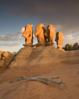
Fall Trip '07: Hole In The Rock Road - Devil's Garden

Near Escalante, Utah:


Fall Trip '07: Hole In The Rock Road - Harris Wash

I made the error of assuming that the access to Zebra Slot Canyon via Harris Wash was from the Harris Wash road and trailhead. Wrong! Six hours of continuous hiking in the sand and streambed later, my wet, cold and well-sanded feet returned me to where I started and I determined that the two best access routes were actually miles upstream.


I rushed to reach Coyote Wash to get to two other slot canyons, but after 30 miles of washboard surface I had a tire blowout as I was arriving, so I my explorations were over for the day.

Monday, October 15, 2007

Fall Trip '07: Little Egypt to Capitol Reef National Park

I decided to do the long drive from Cedar Mesa to Capitol Reef National Park Sunday night, but after hitting a deer I was too exhausted to make it the whole way. I stayed in a rest area near the Hite Crossing Marina on the upper reaches of Lake Powell, or where Lake Powell would be if we weren't in a drought (or if the Colorado River's water wasn't overallocated).

That gave me the opportunity to drive through the gorgeous White Canyon as the sun rose. I was also able to stop at Little Egypt just after sunrise, sort of a mini Goblin Valley on BLM land.

This was my second visit to Capitol Reef National Park, and I headed immediately to the Fremont River crossing that would take me to the 4WD road that leads to the Bentonite Hills. For the 100 foot journey down the river to the road on the other side, the river's water was not up to the bottom of my doors like it was last year, and a grader was actively working the ramp on the other side. The driver was too busy grading to see me, so after several minutes I waited until he drove all the way out into the streambed, then I darted out and behind him, waving as I charged up his carefully groomed ramp. The road on the other side was missing most of the loose, axle-deep sand that almost stopped me last year. It doesn't get any easier than this.

At the end of the day I did the tourist drive into the main canyon by the visitor center. At the end of the road I decided to take a "shortcut" on the map, marked like the well-graded roads that I had been driving all day. The "road" turned out to be South Draw Road, a serious 4WD trail, so it took me 4.5 hours to go the next 25-30 miles. At one point I was getting out about every 30-40 feet to scout the obstacles ahead. I was lucky to get through without a backup vehicle to pull me out of gullies or off of rocks. Fortunately I hadn't expected the condition of the road, so I was short on water and that encouraged me to press on through rather than drag it out into the next morning.

I pulled it off, so the memory is of a great challenge successfully overcome, rather than a poor decision that turned into a survival story. A couple of times I was a few tire slips away from having it turn out differently. Lesson learned: next time I'll carry more water, hopefully be driving something better equipped for off-road trails then a stock Ford Explorer with aging tires, and I'll do the trip in daylight so I can capture photos of the most exciting parts!

Again I had some adventures that slowed my progress, but that's the charm of adventurous travel! I rolled into a viewpoint at around 9000 feet in elevation a little bit after midnight, and looked forward to a sunrise view the next day.

Update: I looked up South Draw Road on the Internet, and the one review of it that I found says, "Best advice: TURN AROUND at the park boundary"!

Sunday, October 14, 2007

Fall Trip '07: Monument Valley to Cedar Mesa, Utah

On this trip I arrived at Monument Valley in time for sunrise. Some of the best shots I've seen of Monument Valley were taken at sunset, or with interesting weather such as lightning.

This ruin is in Road Canyon in the Cedar Mesa area adminstered by the BLM in Southern Utah. Commonly referred to as Fallen Roof Ruin, it is popular among photographers for its picturesque pattern on the ceiling. Many artifacts such as pottery shards seem to have been looted by prior visitors, but there are still 700 year old pieces of corn in the granary to the right. Corn at that time was about 4" long!

Wednesday, September 13, 2006

Western States Photography Tour: Fantasy Canyon

I'm generally on my way towards Colorado, but my next destination is Teapot Rock, which is found on the Bureau of Land Management's Fantasy Canyon site in Utah, not far from Dinosaur National Monument.