Monday, June 29, 2015

Yosemite With Pride Mountain Vineyards Merlot

I picked this gem up at the winery in September 2000
Happy Birthday Mom!
I really enjoyed my last bottle of 1998 Pride Mountain Vineyards merlot while waiting for our dinner reservation at the +The Ahwahnee Hotel on Thursday. I've been hoarding it for most of its nearly 17-year life! It held up remarkably well, particularly for a merlot, thanks to its ample concentration from growing on well-drained mountainsides, and its original balance of tannins and mouth-watering acid. The only unfortunate part was that I don't have any more, so I'll need to make a road trip to +Pride Mountain Vineyards, up on Spring Mountain between Napa and Sonoma Counties, sometime soon.

The 1998 merlot was so good, when I saw the 2012 Pride Mountain Vineyards merlot on the wine list with dinner at the Ahwahnee. There were 12 of us who came together in the park to celebrate my mother's birthday.  I don't think that she had eaten there before, so the meal was a special treat for her during the family reunion week.


Prior to moving to photography full time I was a wine broker, and before that an avid wine consumer as I worked for various Silicon Valley high tech companies. I attended major wine industry tasting events and held weekly blind tastings with friends. I eventually published thousands of tasting notes on the Internet, starting with a home page on my AOL account in 1995 or so.

Needless to say, I found some great wines and wineries.  I added the labels of some wines that I enjoyed in an album on Google+ and one on Facebook... the wines I enjoyed once scanners became inexpensive enough to attach to PCs.

I still stop at wineries whenever I have the chance as I travel.  It's nice to enjoy wines for their own merits rather than primarily in the context of business, but there's no reason why I can't share my latest finds, much like I did with friends back in the 1990s and early 2000s.

I originally typed my tasting notes into a spreadsheet, where I could 
sort the data, but I was also able to add columns for HTML code, and easily paste it all into Web pages.  It seems to work well for blog posts too.  Here, for example, are some of the other times that I enjoyed Pride's '98 merlot:

1998 Pride Mountain Vineyards Napa County 64% Sonoma County 36% Merlot $38.00 02/16/03 - The rumors of this wine's demise have been greatly exaggerated, it's still delivering the goods. Thick and syrupy supple black fruit with an ample but very well integrated tannin backbone, this is a merlot for cabernet drinkers. Its prodigious mass and subtle herbal notes on the finish may have some enthusiasts crying "oak", but this is the controversial vintage that the winery insisted spent only about 15% of its life on new oak. This is mountain fruit from a cooler climate than the Napa Valley floor, so neither characteristic rings any warning bells on my palate and I didn't pick up caramel/vanilla/smoky/graphite notes that dominate many well-oaked wines. Instead, I simply pair it with a cabernet meal (bacon-wrapped filet mignon in this case), hang on and enjoy the ride. With supporting acidity hiding behind the waves of fruit and mouth-tickling tannins, I predict that this wine has years of life left ahead of it. It may well slip into an awkward/backward period in mid-life, like some Sullivan merlots can (the 1990 comes to mind), but many hardy souls will enjoy this wine over much of the next 10+ years. 92

1998 Pride Mountain Vineyards Napa County 64% Sonoma County 36% Merlot $38.00 06/15/01 - Wow! Blackberry, exotic spices (asian five spice), cinnamon bark, eucalyptus, INTENSE, plush, supple earthy notes in the background. 93 *

1998 Pride Mountain Vineyards Napa County 64% Sonoma County 36% Merlot $38.00 05/13/01 - Smooth and supple, vanilla, spices, smoky, ample concentration without being clumsy. 93*

1998 Pride Mountain Vineyards Napa County 64% Sonoma County 36% Merlot $38.00 11/14/00 - Creamy, with coffe and spices. Closed. 92

1998 Pride Mountain Vineyards Napa County 64% Sonoma County 36% Merlot $38.00 09/02/00 - Dark fruit, tarry blackberry, dry and tight with good acid on the finish 92*

1998 Pride Mountain Vineyards Napa County 64% Sonoma County 36% Merlot $38.00 05/05/00 - Dark with a big, ripe, Bordeaux-like nose, firm blackberry mountain fruit, wonderful texture, tarry, smoky finish, rustic tannins, decent length. 92*

Given how easy it is to paste HTML code, I should look into getting my database back online! 

Tuesday, June 23, 2015

Chasing the Aurora Borealis in the Eastern Sierra, June 23, 2015


I read online yesterday that a particularly intense solar magnetic storm might enable the aurora borealis to be visible across much of the United States, as far south as San Francisco and Lake Tahoe. I could see from early results posted from the East Coast and Missouri that the event was progressing as expected.

The aurora borealis tends to be strongest in the location on the earth opposite the sun, and at 11 pm the aurora forecasting apps were showing the strongest magnetic field dipping down in the middle of the United States, so I had roughly one to two hours before that strongest part of the storm would reach us in the Western U.S..

The best visibility of the aurora would be to the north, but I live south of the light pollution from the Carson Valley and Minden/Gardnerville Nevada. There is also the Washignton Fire sending smoke in that direction, so I headed a few miles south then up into the Sierra Nevada to get further from lights and above the smoke.

Partway up the steep road I shot to the north, but the light pollution was too great, so I continued higher.  I tried shooting more to the east to cut out light pollution to the north, and there was a promising increase in green and red color in the sky, but common airglow can cause both of those colors, so I needed to try shooting a sequence of images and create a time-lapse video to see if the red-pink color on the horizon would dance like you see in aurora videos.

Sure enough, there was some aurora color on the horizon, and it gained in strength, shooting upwards into space and dancing across the sky:


I shot the time-lapse video from the high, dry, clear skies of the Sierra Nevada, near the Little Antelope Pack Station above the town of Walker, California: https://youtu.be/NaQiOQrQ_S8?list=PL6012D9822C1BA1E7

For comparison, I also shot the sky more to the south- southeast, to get a reading of the ambient green and red airglow colors in the sky.


It was cool to see the aurora borealis all the way down here along the California - Nevada border.  The forecast for tonight isn't quite as strong, but it's a rare opportunity that is hard to resist, so I may have to go back out and try again!


www.JeffSullivanPhotography.com
The rays of red light could be 65 miles high above the earth, and 600 miles north!

Washington Fire South of Markleeville Grows

Smoke from the Washington Fire obscures the sun, as seen from Topaz Lake Sunday afternoon 
It's always interesting living in the Eastern Sierra, perhaps never more so than when you wake up one morning and discover that a wildfire is heading your general direction.  That was the situation yesterday as the Washington fire burned near Ebbetts Pass and Silver Peak in California's Sierra Nevada.  The fire started Friday, and by Sunday morning it had grown to 350 acres.  But the forecast for Sunday was dry and windy, so it had been identified as being a "red flag" day with the highest possible fire danger.

The Washington Fire near Silver Peak
Heading up on Highway 89 over Monitor Pass, the fire could be seen near Silver Peak, still fairly well localized, but with growing winds sending the smoke towards the Double Springs neighborhood and Simee Dimeh Summit.  Highway 4 was closed from Ebbetts Pass to its intersection with Highway 89 over Monitor Pass.

Depending upon the wind direction, the fire could head towards the town of Markleeville in Alpine County, California, over Monitor Pass towards Topaz Lake on the California/Nevada border, or towards neighborhoods in Nevada along Highway 395 between the two.  The most immediate concern was the town of Markleeville if the fire spread north, but with trees dry from drought and two days of high winds in the forecast, the fire could easily jump the East Carson River and head into Nevada.

Highway 89 over Monitor Pass
Early in the morning the smoke was a gray color and not too dense, although it spread over the landscape for many miles.  The winds grew quickly though, fanning and spreading the flames, and the smoke spread higher and became more thick.

The edge of the smoke plume over Topaz Lake
By mid-afternoon the wind had shifted to center the smoke plume between Simee Dimeh and Topaz Lake, and the color had turned more orange-brown.  The light filtering through the smoke turned the landscape orange.  Winds were gusting over 45 MPH, and the fire was reported as spreading quickly through 6500 acres, jumping forward via wind-carried embers.  Highway 89 over Monitor Pass had closed, residents south of Markleeville had been evacuated, and residents in town were put on notice.

The smoke as seen from Leviathan Mine Road
By early evening it seemed like a good idea to get an update on the fire's location and direction, but online updates can be sparse and vague.  With the high vantage points around Monitor Pass closed, the next best option would be to see what could be seen from the north/northeast.

Leviathan Mine Road departs Highway 395 at Simee Dimeh Summit and heads to Highway 89 on the west side of Monitor Pass, but it crossed directly under the dense, now tobacco-brown smoke.  But the road entered into the smoke that showed the fire's path in the wind.  Without better information on the fire's location and speed, it would not be wise to enter the area.

I captured some photos and video clips from a safe distance north of the smoke, then returned to Highway 395.  Heading south from Simee Dimeh to Topaz Lake, the smoke had darkened to dark brown.  It was so dark, vehicles had their headlights on.

The wind died down in the evening, so the spread of the fire slowed and the smoke less dense.  As of Monday morning, the acreage of the fire hasn't been updated since yesterday afternoon, but the fire has been reported in Bagley Valley south of Highway 89 and Heenan Lake, so the fire has crossed the East Carson River.  It has also been reported north of Highway 89, so it has also crossed the only paved roads between the original fire location and the neighborhoods along Highway 395.  With another day of wind gusts up to 40 MPH in the forecast, we just have to hope for a wind direction which will not bring the fire too close to homes before the wind subsides and the firefighters can work on the advancing edges.

The +Pacific Crest Trail Association published this map earlier today showing the extent of the fire:
I'll upload more photos to DripThat, a new app and community which facilitates the telling of stories through pictures, video and text.  You can find the DripThat app in the Apple App Store http://bit.ly/1dhaequ (Android soon), and you can connect with me in the community to see more of my photos from my road trips: https://dripthat.com/pr?id=jeffsullivan

This information is on behalf of dripthat.

Thursday, June 18, 2015

Moon, Venus Jupiter Will Line Up Tonight


Tonight we'll have the Moon, Venus and Jupiter lining up in the evening twilight sky, with a 9% crescent moon about 9% high in the sky around 9 pm (in a mid-California latitude).

Yosemite Valley isn't normally where I would go to see expansive views of the night sky, but on February 24, 2012 I was fortunate to arrive at Sentinel Bridge over the Merced River right before the moon set behind the valley rim, with Venus and Jupiter lined up above. I was able to capture this frame with the moon and Venus reflected.

Tomorrow evening 
the moon will be brighter and set later, forming a triangle with Jupiter and Venus.  With the evening sky also darker, it will be reminiscent of the Venus, Jupiter Moon triangle I caught last August:

Photos of the Moon, Venus and Jupiter Conjunction August 23, 2014
http://activesole.blogspot.com/2014/08/photos-of-moon-venus-jupiter-conjunction.html

Here's a photo of those three members of our solar system rising on the eastern horizon:


Then Saturday night the moon will be a brighter, wider crescent, and set later in a flatter triangle configuration, more reminiscent of this one earlier this year:


The easiest event of the next 3 nights to catch with earthly terrain will be the more linear configuration tonight, while twilight light still lights up your foreground landscape.

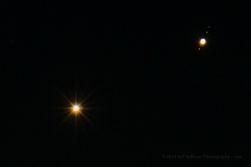
At the very end of the month, on the night of June 30, Venus and Jupiter will pass within 1/3 of a degree of each other, less than the diameter of the moon.  It will be similar to the conjunction (appulse) that I caught last year on August 18 on my Canon 70 with EF 70-200 mm lens and 2X teleconverter, but this time Venus will appear as a crescent.

Jupiter Venus Conjunction, with Four Moons

Thursday, June 11, 2015

Exploring a Ghost Town at Night: May 24

Main Street Bodie under moonlit clouds
After our last sunrise and interior access session at the old mining ghost town of Bodie State Historic Park on Memorial Day Weekend, we headed out for lunch and rest before we'd return at 6 pm for sunset and night access.  The park isn't open at night, but we had an arrangement with the Bodie Foundation to provide funds for the park's preservation of buildings in "arrested decay", so they provided monitors to accompany us around town after hours.  

Rain showers were moving through the area throughout the afternoon, and we had varying degrees of cloud cover for our first two hours in the park. At 7 pm big, puffy clouds looked like they'd let some sunset light through about an hour later.

At 8 pm however, it started to rain.  Hard.  This was right when we should be out shooting sunset, but we had to take cover in a meeting room.  We watched an informative video on Bodie, but that wasn't what we were there for, so watched to see if the rain would subside.

Fortunately Bodie is located in a high desert ecosystem, and much of the 0.7 inch average precipitation for May falls in a storm or two, like the one the night before.  Other rain events are just a passing shower, and the cloud which had dumped on us had moved on by 9, and we went back out for amazing blue hour light.  The clouds were still moving fast, and they blurred in the sky as we set our cameras for 30 second exposures at Bodie's Methodist church, built in 1883.  There wasn't much light on the landscape, but a little light painting on the church helped that show up nicely. 

The moon was nearly a quarter moon, so as the clouds began to break up, it was backlighting them as the stars started to peek through.  We went to Bodie's classic, rusty 1937 Chevy and did some light painting to give it a little extra character in the moonlight.  People say that it may be the most photographed car in the world.  It is certainly the one that I have photographed the most!  The clouds started to break up as we were shooting the Chevy, so we decided to go see how conditions were after the rain down on Main Street.

We walked down Green Street to Main Street, and found that the puddles we had seen earlier in the day had been refreshed by the passing storm.  You don't find standing water in the high desert very often, and it doesn't last long, so we were lucky to have just followed a passing storm, twice now in the same day!

We captured a variety of buildings in various puddles, and the sky gradually cleared and showed more stars as the moon neared the horizon.  We moved to capture the green truck downtown, which I understand is a 1940 Ford commercial vehicle, before starting to head back towards our gear and our vehicles.  With the moon now out of the sky, many of the participants had time for one last shot of the Milky Way by the mining headframe up by the parking lot before we hit the road.

Having started the drive to Bodie at 3:30 am to get there by 5, I had some coffee at 10 pm to keep energized, but now I was too tired to sleep, so I just drove home, arriving around 2:30, 23 hours after I had left.  


It was a long day, but we enjoyed two of the best and most interesting special access sessions that I've experienced, in the 20+ that we've arranged over the past 4 years.  They just keep getting better the more we do it.  I can't wait for the four more dates we have scheduled in Bodie from June through October this year!

I didn't have room to include all of the photos that I wanted to show you in this blog post, so I'll be publishing more via DripThat, a new app and community which facilitates the telling of stories through pictures, video and text.  You can find the DripThat app in the Apple App Store (http://bit.ly/1dhaequ), and you can connect with me in the community to see more of my photos from my road trips: https://dripthat.com/pr?id=jeffsullivan

Shooting Bodie's Wheaton & Hollis Hotel and reflection

This information is on behalf of dripthat.

Tuesday, June 09, 2015

RAW vs JPG for Mobile Phone Photography - LG G4


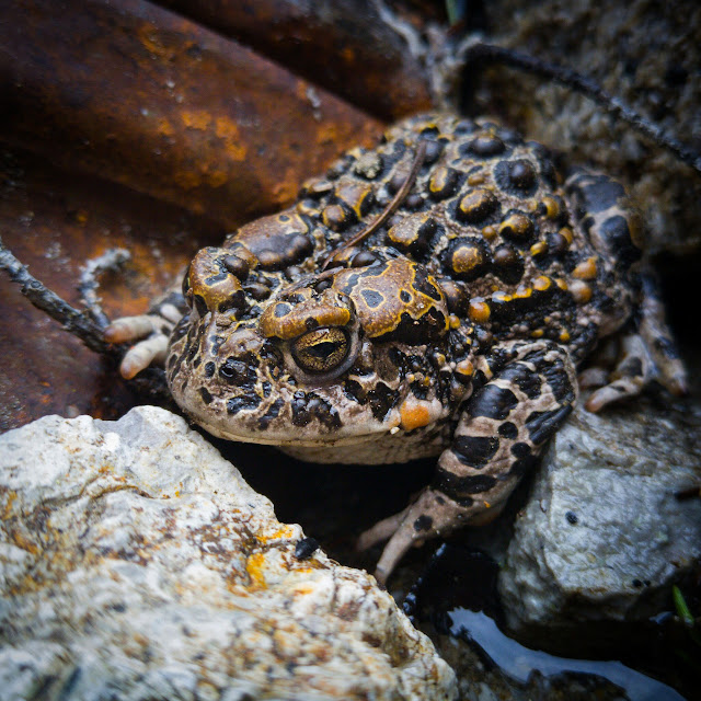
LG G4 RAW capture, manual exposure, unadjusted, cropped to 2047 x 2047, saved at 90% JPG quality, Adobe Lightroom 5.7.
I continue to experiment with manual exposure and the ability to capture images in RAW format on the LG G4 mobile phone, since it's one of the first (the first?) phone cameras to offer that capability.  Above is the RAW file.

Next let's look at a copy edited in +Adobe Photoshop Lightroom mobile on +Android:

Image adjusted in Adobe Lightroom mobile app, color, contrast, etc, vignette applied.
The original files are 5312 x 2988 resolution, 16 megapixels. This was cropped square, top to bottom in the original frame, so it was 2988 x 2988, but it's displayed at 2048 x 2048 here.  Looking at the Lightroom folder on the LG G4, that downsize in resolution seemed to happen automatically in the Lightroom software.

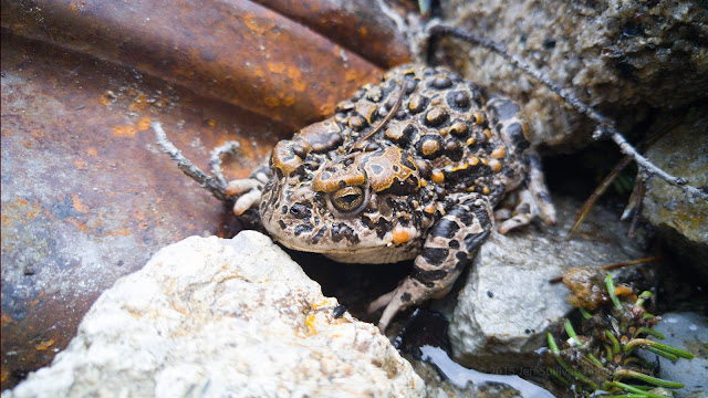
Now I'll upload the original RAW file here, saved to JPG (80% quality) so it will display:


The unadjusted RAW file was 20 MB, then saved to JPG 80% resolution it's now 6.56MB
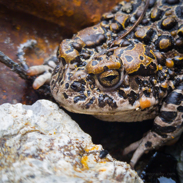
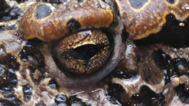
But guess what I was actually taking a picture of... I was trying out an 8X digital zoom on the toad's eye from about 4" away, so I could see how a macro-like the result would turn out.  I was shooting in RAW + JPG mode, and this zoomed view saved at the same and with the same file name as the wider RAW file above:

8x zoom from 4" away! (JPG file created by the LG G4 alongside the RAW image with wider field of view)
The LG G4 has an 8-way optical image stabilizer, improved from the 4-way OIS on the LG G3.  Multiply hand shake with 8X zoom, arms outstretched to ground level, a few inches from the subject, and this is an impressive result.  Next I'll have to try it with the phone stationary to test the phone's close focusing and image quality without unsteady hands being a factor.

What's interesting about this 8X zoom shot is that the file still saves at 5312 x 2988.  If you click on the zoomed JPG, it isn't noticeably jagged with blocks of pixels duplicated many times to the higher resolution.

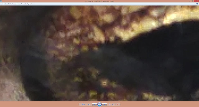
Zooming in on the JPG file saved by the LG G4
Some of that could be dither patterns to map RAW data to the smaller color palette of 8-bit JPG, but there could be some interpolation involved to predict and fill in data as well, so let's look at the JPG save of the RAW file to see what the actual pixel size is.

Zooming in on my 80% quality JPG save of original RAW file to see actual pixel size.
Sure enough, we were a bit over-zoomed on the LG G4's own JPG save of the 8X digitally zoomed image, but it's nice to see dither patterns (in that prior, tighter image) used to approximate more colors.  that's what printers do as well, when you send them a file format with more colors than they have dots of color to represent.

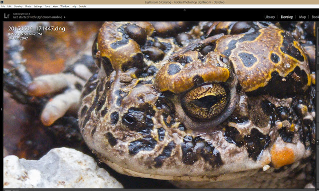
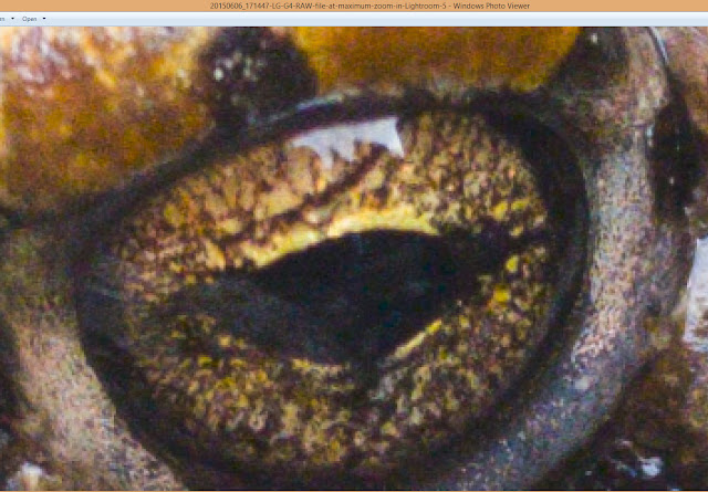
But we're still not looking at the original RAW data... how much did my decision to save at only 80% JPG quality affect the output?  Let's look at the file still in Lightroom, since it should be able to represent the original DNG RAW colors using the full color pallette of the display card.  Here's a screen shot of that:

Now the RAW file adjusted, this is as far as Lightroom would let me zoom on my 1920 x 1080 display.
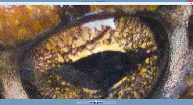
But screen shots are saved in JPG, so by the time someone shows that to you, you still don't get the full data present in the RAW file.  Let's pixel peep on that anyway, fully understanding and acknowledging the limitations:

This screen shot of the adjusted RAW file, as it appears in Lightroom above, was effectively converted to JPG in Windows
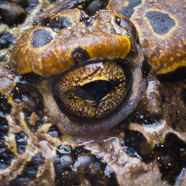
The screen shot of the RAW file in Lightroom was effectively converted to JPG in Windows, but it already looks better than the RAW saved to JPG at 80% quality, so that quality setting was a factor in the prior crop.  Let's now crop the eye first, then save the RAW to JPG at 100% JPG quality.

RAW file cropped to 601 x 601 pixels, saved at 100% quality JPG, inserted into blog at 600 pixels
I've cropped that last image to be inserted into the blog at a 1:1 size, not over-zoomed, and it's 100% JPG quality, so reduced in quality from the original RAW but about the best we can do in JPG format.

Let's repost that unadjusted 8X zoom RAW file that the LG G4 saved again here, for a fairly direct comparison:

That 8X zoom file the LG G4 saved alongside the wider view RAW file.
The adjusted/edited RAW file looks better than the camera-saved JPG file, but that's the whole point of saving RAW in the first place, to have the option to work on the original sensor data and produce a better edit, if and when it makes sense to invest that additional time.

If you're on the run and need to post a quick preview, many reviews confirm that the camera on the LG G4 will produce JPG files comparable with other top phone cameras.  But such reviews of straight-out-of-camera results clearly fail to fully show the full strength of the LG G4 camera, and its ability to produce stunning results, edited either in a mobile app (second from the top above) or in traditional desktop editing software (below).

Adjusted in desktop version of Lightroom (5.7), brightness, contrast, etc, less vignette applied than in mobile version
Conclusion: RAW is clearly the way to go when quality matters, which should give the LG G4 a leg up on competitors for a while, until more of them join the RAW party.

I had been provided with the LG G4 to preview it prior to its public release, but now I have to make a personal decision on which phone to use going forward.  I find that it's what I reach for 90% of the time for general image quality anyway (including low light performance, excellent image stabilization and good quality quick JPG HDRs).

Upon further inspection, the ability to select manual exposure and produce RAW output isn't just an incremental feature, it opens up a while new category of mobile phone camera.  Consider what third party apps can do with that... using exposures up to 30 seconds, producing higher quality results from multiple exposures and HDR or other exposure blending performed in post-processing software.  The applications will span the full range of what app developers can dream up.  This starts to achieve the promise of putting mobile phones in direct competition with digital cameras and even DSLRs.  While lens selection and aperture choices will continue to give DSLRs the edge for many specialized and professional applications, the expanding options and improving image quality from smartphones will continue to expand their appeal as the camera most likely to be quickest into your hand as shooting opportunities arise.

Monday, June 08, 2015

Finding Serendipity in Turkey

Rock tombs on the shore of Lake Bafa, Turkey

During a nearly month-long trip to Turkey, Lori Hibbett and I drove a car across the countryside to see ancient historic sites. We left a few days free in our itinerary to have the flexibility to follow whatever interesting side trips came up along the way.

While visiting Selçuk to visit the ancient city of Ephesus, our hosts at Hotel Bella recommended that we visit Lake Bafa. We had no idea what we would find when we get there, but we booked a couple of nights at the pension that they recommended, Agora Pansiyon.

Lake Bafa is a large saltwater lake, formed when the mouth of a bay field with silt. Hills covered with decomposing granite boulders and olive trees lead up to nearby Mount Latmos. The formation of the lake land-locked the ancient port of Heracleia, also known as Heracleia under Latmos.

Monastery of St. Mary on an island in Lake Bafa
Ancient fortifications dot the hillsides and the lake shore, and many tombs cut into solid stone still have their heavy rock lids askew on top. An island just offshore holds the ruins of the Monastery of St. Mary, dating back to the Byzantine era.

We explored the shore at sunset, then returned to our pension for dinner of fresh fish caught in the lake.  After dinner we returned to the lake for some night photography.


The nearby town of Kapikiri offers hiking trails which lead onto the mountain through small olive orchards, tended by local families and passed down for generations.  One of our hosts at Agora Pansiyon, Mithat Serçin, drove us over to Kapikiri to lead us on a hike.  One of the trails leads to the ruins of the Yedilir Monastery, which has an overhanging rock which housed a small chapel.  The walls which enclosed the chapel are gone, but various bible stories are still painted on the underside of the rock overhang.  A pile of rocks nearby was used to house beehives, for gathering honey.


Rock overhang near Yedilir Monastery ruins
On the way up we stopped to see ancient cave paintings, at one of nearly 200 sites cataloged on this mountain.  The area has been occupied by people for thousands of years.  On the way back down the mountain, we found a baby tortoise on the trail, smaller than a walnut!

It definitely can be productive to leave some portion of your trip to chance, to serendipity, and see what unexpected bonuses pop up along the way.

I don't have room for many photos in this blog post, so I'll post more to the new DripThat app, currently available on IOS devices (coming soon for Android).  Like a cross between messaging and social media, DripThat is perfect for travelers, for telling stories through pictures and video clips.

Lake Bafa at sunset

This information is on behalf of dripthat.

Friday, June 05, 2015

Chasing the Moon: Lunar Eclipse Photography October 2014

Partially eclipsed moon setting behind the Sierra Nevada
Lunar eclipses can be a fun challenge to photograph.  The moon is so much brighter than the landscape, most photographers simply choose to expose for either the moon detail or the landscape with the too-bright moon over it.  Even the exposure for the moon itself can be a challenge if you try to capture detail in both the lit and shaded portions of the moon's surface while the moon is partially eclipsed.  Of course the challenge only gets greater if you try to zoom in on the moon's surface, and the moon orbits the earth and moves relative to your position on the surface of the rotating earth.

I captured the moon from three places on the night of October 7-8, 2014 in the dark skies of the Eastern Sierra: first from the shoreline of Mono Lake as the full moon rose just before sunset, then from the shoreline of Convict Lake as the moon entered totality and then exited totality just as it was setting behind the Sierra Nevada, and finally from Minaret Vista as the moon, still in the penumbral phase of eclipse, set behind The Minarets just before dawn.  


Composite shot captured using an ultra-wide lens
The Mono Lake sunset moon rise was pretty straightforward, since the moon and landscape can both be picked up clearly in a single exposure then the moon rises just before sunset.  The moon went behind a cloud as it continued to rise during blue hour, enabling more nice shots without having to process multiple exposures.

I tried a number of things at once during the eclipse.  I had three cameras going, one to capture only a wide angle sequence of the landscape and moon and its reflection in Convict Lake as the moon went in and back out of totality, a second camera to capture a telephoto time-lapse sequence of the eclipse on a sky-tracking mount, and a third one simply to assess exposure changes, so I could reset the other two cameras on the fly to follow the changing brightness of the moon.


Since the moon takes a while to get fully out of the the earth's shadow, once the moon set at Convict Lake, I had time drive to Minaret Vista and arrive in tome to capture it setting.

As a major bonus, I realized that the blue dot i was picking up just to the left of the moon during totality was the planet Uranus!

I was pretty tired after getting very little sleep that night, but of course it was completely worth the time and effort.  I can't wait for the next lunar eclipse, coming up this fall.


Update June 2015: I'd like to thank the +The Huffington Post UK for featuing my composite eclipse sequence image in an article featuring photos entered in the 2015 Astronomy Photographer of the Year contest conducted by the Royal Observatory at the +Royal Museums Greenwich : http://www.huffingtonpost.co.uk/2015/06/03/astronomy-photographer-of-the-year_n_7500346.html?1433327342 I'll place more of my photos from this lunar eclipse on the new app +dripthat: http://bit.ly/1dhaequ

The blue planet Uranus could be seen just to the left of the eclipsed moon during the total eclipse in October 2014

Exploring Ghost Town Interiors, Bodie May 24

Morning after the storm in Bodie
We had a great schedule planned for our photography workshop in the historic mining town of Bodie on Sunday, May 24.  It had been raining the day and night before, so would the weather cooperate?  The weather forecast predicted a 30% chance of rain for the day, and it was mostly cloudy when we arrived at 5:15 am, but there were signs that the cloud cover may break up.


When we arrived on Main Street we were pleasantly surprised to find puddles of water in the street.  The sun didn't break through the clouds enough at sunrise to paint the clouds shades of orange, but there were plenty of unique shots to be found thanks to the prior night's storm.  Gradually we started to see patches of blue sky peeking through the clouds

We visited the popular buildings like the Lottie Johl House, which has lots of furniture inside.  It's amazing that so much has survived from the town's past: couches, tables, chairs, beds, a gun rack, a cast iron stove, even silverware.  There are appliances such as washing machines, vacuum cleaners and radios, and personal items too, like clothing and toys.  


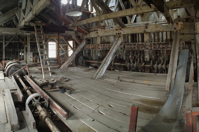
Our monitors from the Bodie Foundation, Norm and Dave, offered to show us around the Standard Mill, where the gold ore was chushed, and naturally we accepted.  Gold ore entered on rails at the top of the mill.  Electric motors turned wheels and belts to drive camshafts which raised and dripped heavy stamps to crush the ore.  From the now-powdered rock, gold would get trapped in mats on tilted tables, much like a sluice box.  
The Standard Mill was originally steam powered, and we saw the old boilers underneath the rest of the building.

During the course of the morning I lost track of how many buildings we explored, but it was close to 20.  I captured dozens of photos, more than I can comfortably fit in blog posts, so I'm trying out a new app DripThat, which lets me publish photos over time.  The DripThat app is available on the Apple App Store, and you can connect with me there as well to see more from this trip to Bodie: 
http://dripthat.com/profile/jeffsullivan


See more of my photos on DripThat: https://dripthat.com/pr?id=jeffsullivan


This information is on behalf of dripthat.