Welcome to my photo travel blog. I am a landscape and night photographer who conducts photography workshops in some of America’s most exotic landscapes.
I just completed a travel guide to the best landscape photography locations in Southern California, to be available in September 2015.
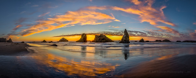
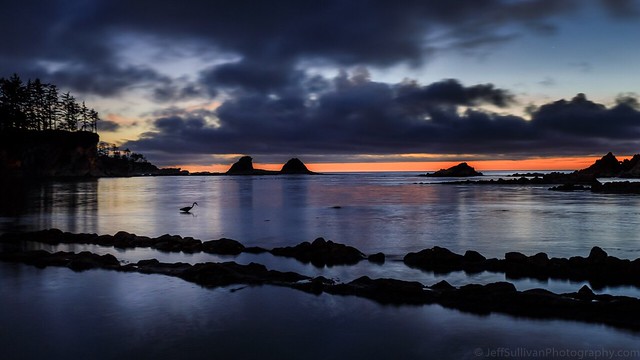
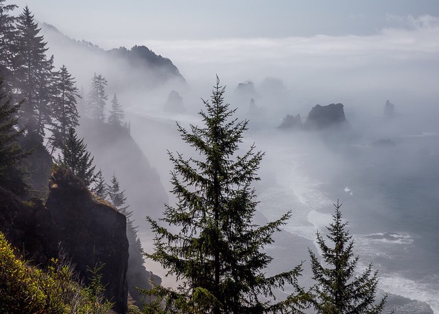
I just completed a 2000-mile trip to revisit some of my favorite places in Oregon. Although I lived in Oregon for years in the 1980s and revisited a lot in the mid to late 2000s, I hadn't been to some of these places in years. Even with 2+ weeks it wasn't enough time, so I'll just have to go back soon!
I don't know when I'll get around to uploading all of my photos from my recent Oregon Coast photography tour, but here are a few images that I've uploaded so far.
What's your favorite place along the Oregon Coast?
Photographing California - South, my new landscape photography guidebook
I'm one step closer to being able to ship you a copy of my new guidebook to the best landscape photography locations in California, from Yosemite National Park south. I received the first sample copy, express-shipped ahead of the boxes and boxes of copies which will ship to retailers.
In the next few days I'll set up a purchasing link for pre-orders and author-signed copies, so I've set up a mailing list with a sign-up form below, where you can opt in to hear about its availability:
The book covers a lot of what you'd expect, including Yosemite National Park, Death Valley National Park, Joshua Tree National Park, Kings Canyon/Sequoia National Park, Channel Island National Park, Pinnacles National Park, Mojave National Preserve, Anza-Borrego Desert State Park, Devil's Postpile National Monument, and the California Coast from Santa Cruz to San Diego. It includes many state parks and beaches, sites on land managed by the U.S. Forest Service, Bureau of Land Management, and National Natural Landmarks. I weighted coverage by scenic and photographic value, so the Eastern Sierra gets separate chapters for the Mono Basin, Mammoth Lakes area, Bishop Area, and Lone Pine to Mojave.
Most of the locations covered can be reached easily by car or via a short walk, but also included are a few stunning destinations best reached using high clearance or 4WD vehicles, overnight backpacking, or horses. In all, over 350 photos are provided to illustrate over 300 locations, and many site entries reference additional nearby areas worthy of additional exploration.
The photographic potential of a site can vary by season and by time of day, so I advise readers on both seasonal timing and when the light is best. Where there are special technical photographic considerations such as optimal focal lengths or filters to use, I describe those as well. Seasonal considerations can include the angle of the sun, wildflowers, fall colors, peak waterfall flows and special events such as lunar rainbows. Somehow I packed this all into 320 pages!
The book is the latest volume in the publisher's series covering many Western states, and an ebook version will be available as well. This project was a massive undertaking, taking twice as much time as I expected, about 5 years. To complete the book I drove a distance roughly equivalent to halfway to the moon. Death Valley alone warranted approximately 20 visits to explore new locations, even after having already visited the park that many times already over the prior 5 years as well. I'm crazy about nature, landscapes and photography, so I'd do it over again in a heartbeat. Completing this book was the experience of a lifetime!
I'll recoup my travel expenses slowly and it may be years before I get anything extra to cover my time, but I keep the retail markup on the author-signed copies, so your direct purchases through me provide maximum support for this project.
If you prefer free shipping copies from an online book retailer, no problem, I'll have a link for ordering it through my "astore" there, and even the few dimes more in commission I'll receive from using that link will help greatly towards making this project viable (compared to ordering it directly there without my affiliate link). You can also order it alongside other books in the series, once the listing for my book goes live.
I'm generally fairly shy and not really comfortable asking for things, but if you tell your photographer friends about this book, it you buy copies for birthday or Christmas gifts, or even just "Like", comment on, or share my social media posts to help spread the word on it, you'll be doing me a huge favor. Thanks in advance for your support, in any form it might take!
Based on the success of this book release, I'll decide whether to move right into another travel guide. If I do, what would you like me to cover next, Nevada, the High Sierra, Wyoming or Montana? Drill down in more detailed regional guides (Yosemite, Death Valley, Eastern Sierra)? Something international, perhaps Patagonia or Iceland, or more developed travel destinations like Italy, Spain, Switzerland, Turkey? Tell me in the comments. If I can pick my next project now, I can set it up on Kickstarter and use this first book as one of the rewards for your support on my next one.
Last but not least, thanks to everyone who cheered me along over the years, on Facebook, Twitter, Flickr, Instagram, Google+, 500px, YouTube, Vimeo, PInterest, Wordpress, Tumblr, and here on Blogger, You kept me going on this long road (looong road). Thanks also to my photography workshop customers, you kept food on the table, a camera in my bag, a computer on my desk, and my car in working order. I have a few more Bodie night photography and interior access dates left in 2015, and as the book sales go into autopilot as retailers pick it up, I hope to resume the Yosemite, Death Valley and Eastern Sierra workshops that I've offered in the past, and add dates to my calendar shortly.
During a nearly month-long trip to Turkey, Lori Hibbett and I drove a car across the countryside to see ancient historic sites. We left a few days free in our itinerary to have the flexibility to follow whatever interesting side trips came up along the way.
While visiting Selçuk to visit the ancient city of Ephesus, our hosts at Hotel Bella recommended that we visit Lake Bafa. We had no idea what we would find when we get there, but we booked a couple of nights at the pension that they recommended, Agora Pansiyon.
Lake Bafa is a large saltwater lake, formed when the mouth of a bay field with silt. Hills covered with decomposing granite boulders and olive trees lead up to nearby Mount Latmos. The formation of the lake land-locked the ancient port of Heracleia, also known as Heracleia under Latmos.
Monastery of St. Mary on an island in Lake Bafa
Ancient fortifications dot the hillsides and the lake shore, and many tombs cut into solid stone still have their heavy rock lids askew on top. An island just offshore holds the ruins of the Monastery of St. Mary, dating back to the Byzantine era.
We explored the shore at sunset, then returned to our pension for dinner of fresh fish caught in the lake. After dinner we returned to the lake for some night photography.
The nearby town of Kapikiri offers hiking trails which lead onto the mountain through small olive orchards, tended by local families and passed down for generations. One of our hosts at Agora Pansiyon, Mithat Serçin,drove us over to Kapikiri to lead us on a hike. One of the trails leads to the ruins of the Yedilir Monastery, which has an overhanging rock which housed a small chapel. The walls which enclosed the chapel are gone, but various bible stories are still painted on the underside of the rock overhang. A pile of rocks nearby was used to house beehives, for gathering honey.
Rock overhang near Yedilir Monastery ruins
On the way up we stopped to see ancient cave paintings, at one of nearly 200 sites cataloged on this mountain. The area has been occupied by people for thousands of years. On the way back down the mountain, we found a baby tortoise on the trail, smaller than a walnut!
It definitely can be productive to leave some portion of your trip to chance, to serendipity, and see what unexpected bonuses pop up along the way.
I don't have room for many photos in this blog post, so I'll post more to the new DripThat app, currently available on IOS devices (coming soon for Android). Like a cross between messaging and social media, DripThat is perfect for travelers, for telling stories through pictures and video clips.
I've been exploring California for many years, and one of my favorite parks is Anza-Borrego State Park. The largest state park in California,
Anza-Borrego encompasses an impressive 600,000
acres (938 square miles). For photography, subjects include wildflowers,
narrow, winding slot canyons, eroded badlands, cracked earth on a dry lake bed, desert plants including cacti and ocotillo, over 100 large, rusty metal sculptures, and more. The most comfortable time to visit the park is in the fall, winter and spring months, avoiding the summer heat. In late February through March, you may encounter a decent wildflower bloom.
My favorite location in the park is probably Fonts Point, which offers nice views for both sunrise and sunset. The only problem is that you have to drive for miles up the loose gravel of a dry wash to get there, so it's best reached in high clearance vehicles, even better if you have 4WD. The rusty metal sculptures scattered around the desert surrounding the town of Borrego Springs often depict animals from the region's past. They make popular subjects for night photography. The adjacent community of Borrego Springs has been recognized by the as a Dark Sky Community for its efforts to preserve visibility of the night sky. The nights around the new moon dates in the summer are particularly good for Milky Way photography, and any clear night is good for star trails. Not far to the east is the Salton Sea, and the 200 square miles of dunes at Imperial Sand Dunes can be productive for photographers to explore as well.
As I mentioned here on my blog recently, you can browse the latest photos from California's over 11,800 parks on the new Web site Caliparks.org.
If you use Flickr, you can also browse my Anza-Borrego album there for more photos from this park, to get an overview of the types of sights that you can see: https://www.flickr.com/photos/jeffreysullivan/sets/72157650176184687
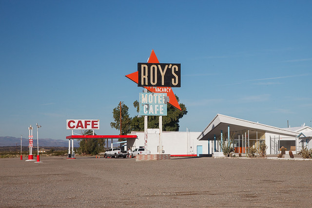
In the spring months I'm often passing through the Mojave Desert, which puts me on historic Route 66. There are a number of old houses and businesses along the way, mostly in various states of disrepair, but there's a nice cluster of buildings worth checking out in the small town of Amboy, including Roy's Motel Cafe, the deserted and overgown Amboy School, and a picturesque, if dilapidated, church.
Amboy Crater
Spring is also the time for wildflowers in the desert, so if you catch the timing right, you can see many species like this desert sunflower with Amboy Crater in the background. Amboy Crater is a couple of miles west of Amboy alongside Route 66, and if it's not too hot you can walk about a mile to the crater itself. The trail winds its way around black lava flows, which warm up in the sun, so brings plenty of water.
Chuckwalla
If the plants are growing green in the area, keep a sharp eye out for several species of large lizards in the lava, including chuckwallas, which grow to 18" long and nearly 2 pounds in weight.
Once or twice a year I head up to Mendocino to go diving for abalone, and I also occasionally reach the California Coast further North on trips to and from the Oregon Coast. Here are some notes for travelers and photographers if you're heading up that way.
Van Damme State Park just south of Mendocino has a fern canyon (photo at top above) a couple of miles hike from the campground. The cove there can be good for sunset or sunrise if there are clouds in the sky, and you can get a reflection of any sky color in the creek lagoon.
Russian Gulch State Park
Russian Gulch just North of Mendocino has a nice view of a bridge past a cove and tree-topped sea stack. You'll see some wildflowers on hikes in either Van Damme or Russian Gulch State Parks. There's also a small lighthouse just North of Russian Gulch (it requires a 1/2 mile walk to reach). There's also a botanical garden in the area (Fort Bragg I believe).
There's an old railroad trestle just North of Fort Bragg that can have nice backlighting just before sunset. You may enjoy shooting around Noyo Harbor in Fort Bragg as well.
Point Arena is about 45 minutes South, and it has the tallest lighthouse on the West Coast, which you can capture in good compositions from half a dozen directions.
Sunset at Greenwood State Beach
About halfway from Mendocino to Point Arena is Greenwood Beach, available via a short hike, where the sun will set near offshore rocks.
Three miles or so further south are Schooner Gulch and Bowling Ball Beach (visit Bowling Ball at low tide to see the round rock formations). Osprey are often diving for surf perch off of Bowling Ball (I watched up to 9 or 10 of them fishing at once).
If you drive up Highway 1 you can stop at Kruse Rhododendron State Park . The flowers peak in May, but may still be around by June. You can catch some fern and redwood shots there anyway.
You'll see some interesting cliff and surf views just North of Salt Point State Park.
The Sea Ranch area has a tiny church with bizarre architecture just East of Hwy 1.
Church in Bodega Bay
Further South, the town of Bodega Bay has a large white church that Ansel Adams took a well known shot of.
Whether you drive to the coast from Santa Rosa to Bodega Bay or Jenner, or via the Anderson Valley, you will drive past vineyards and wineries that could provide photographic opportunities, especially if you call ahead and identify one that will give you a cellar tour.
Driving down the Russian River towards Jenner there's a unique golf course set in old growth redwoods. Just past the town of Jenner near the mouth of the Russian River are a lot of sea lions and elephant seals waiting for steelhead and salmon to snack on.
Further North there's a great fern canyon (photo above) at Prairie Canyon State Park, which is co-managed as part of Redwood National Park. TV host Huell Howser said it was his favorite State Park, and he had seen hundreds of them (literally).
If you want to do something a little different, there's a dive shop in Fort Bragg that can rent you everything you need to dive or snorkel. Call ahead to see if they rent underwater housings that will fit your camera. The cove at Van Damme has abalone, nudibranchs, etc., but the kelp may be getting pretty thick by early June, and the somewhat warmer water in the cove a bit clouded with algae (Russian Gulch may be a better dive spot then, or you can get a recommendation from the shop). Check for particularly low tides during your visit and you may be able to catch some nice shots in tide pools.