Showing posts with label Northern California. Show all posts

Friday, May 27, 2016

Eastern Sierra Conditions Spring 2016


The aspen trees are starting to leaf out
My early May blog post on spring Eastern Sierra conditions contained a collection of possible outcomes and opportunities for spring.  I've been out a few times since then, checking the emergence status of various wildflowers, the water level at Mono Lake tufa sites (and their muddiness, since they form over springs), unpaved road access conditions, snow levels and lake iceout conditions around Tioga Pass, pond water levels and reflection opportunities in Yosemite's Tuolumne Meadows, bird and wildlife photography opportunities, and so on.

A quick snapshot on my iPhone 6S+ - good enough to show the arrowleaf balsamroot starting to bloom

Wildflowers vary in intensity and timing from year to year, which is why I do these scouting trips before the workshop, and not while dragging customers around.  Even knowing where various species can be prolific, checking the current year's status and timing involves many less than fully productive searches.  Wild iris seemed to be a bit behind in timing.  Mules ears have been starting to emerge over the past 2 weeks, and could peak in the next week or two.  The few days of clearer, warmer weather in the forecast early next week could help them along.  Paintbrush was doing well at low elevations but it is too early to tell how prolific it'll be at mid to high altitudes.  Lupine were healthy in some areas and should still be available for another week or more a lower altitudes, and emerging at mid altitudes.  Wild peach has been strong, and yellow bitterbrush has bloomed as enthusiastically as many local residents can remember (one even mentioned that this native must be a new invasive species), but the peak is now past for both.  Isolated patches offered a variety of other species, sometimes dense, but you really have to search for them.  I'll be back out over the next few days to see if some of the patches have increased in intensity, enough to warrant a visit during the upcoming workshop.

All of the photos in this post are from May 2016


The weather has been unsettled, great for daytime photography as but less conducive for many types of night photography.  That's pretty typical for May, which is one reason why I only ran a couple of Bodie night photography workshops then, but currently focus more on June and later.

Some locations are on the wet and muddy side, not unsurprising for spring, but certainly good to know before you show up for a sunrise or sunset and can't access the compositions that you might have enjoyed in the past, in summer, fall, or simply a drier year.  In other cases, a site might be more dependent upon long term trends, and the long term drought continues to provide cracked earth foregrounds.  If you're shooting in one basin and the weather and light looks like it might be better 25 miles north or south, you can save an hour of driving if you know that the site that you have in mind isn't in great condition that week.  Conversely, you can make your day, week or month if you know that a site is in great shape, and you arrive to find great light to complement the site's full potential.  A good workshop is made great when you can "connect the dots" to consistently arrive at a series of good sites, in great seasonal condition, offering optimal lighting, while reacting to the day's weather conditions.  There are no guarantees in landscape photography, and that's part of what makes it exciting, but scouting trips do resolve what would otherwise be unknowns in the mix, increasing the odds of everything coming together just right.

A quick iPhone snapshot is good enough to record conditions, break out the DSLR upon returning in better light


The somewhat early opening of Tioga Pass is not surprising given a fairly dry month of February and the winter's overall normal to low snowpack (93% in the Mammoth lakes area, closer to 100% north of Tioga Pass).  It has re-closed at times as moisture causes afternoon and evening storms, but it's open again now.  Lakes are in various stages of losing their ice.  Tenaya Lake was clear by the time the pass opened, Ellery may be completely clear now, Tioga was mostly frozen last week, so it may still hold some ice into next week.  The terrain is complicated up in that area, so having spent many sunrises and sunsets up in that area is important to knowing what is likely to be productive, vs. a bust.

Tuolumne Meadows currently offers a lot of seasonal ponds.  Determining ahead of time which of them provide decent compositions at current water levels helps keep the workshop moving efficiently.  Many workshop leaders spend a lot of time and money marketing, and do a great job filling their workshops.  Good for them.  I prefer to spend my time in the field, develop extensive site and condition knowledge, and over time earn the reputation for delivering great opportunities and results.

It's important to me for my knowledge to include photographic technique and post-processing skill.  Anyone can apply a filter in post-processing software or use a certain technique to make a landscape look wacky, and there's nothing whatsoever wrong with that, it it's the style someone chooses, rather than is trapped into through less than optimal exposure technique or lack of alternate post-processing workflow options.  Getting through the end-to-end digital photographic process with realistic results is like walking a tightrope: bay far the easiest thing to do is to fall off.  There are subtle things you can do all along the way to optimize results.  You don't need the latest camera or software, it's more about fine tuning the various steps.
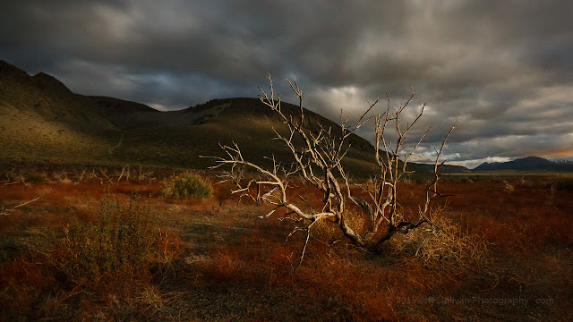
Backlit storm clouds at night


Ansel Adams produced timeless results by producing heavily manipulated but seamlessly realistic results, while popular trends included hand-tinting photographs to add color.  Most of us don't know the names of his contemporaries today.  No doubt Ansel could have had great commercial success producing those colorized postcards, but any era's hot trends can look cartoonish years later, out of the unique social context of the time.  We're not immune from that today: I have over-saturated digital photos from the mid-2000s, tonemapped HDRs from the late 2000s, and I've dabbled with luminance masking, color light painting, and lately software filters.  I gravitate more realistic results, and for the experiments with various trends, I'm gradually re-processing many of the more over-the-top post processing results.  It's useful to try a range of things to settle on your own preferred style, and to continue to try new things for variety and to see if you want to broaden your options for post-processing any given scene in the future.  So I want to maintain a broad enough collection of experiences to be prepared to help photographers who want to expand their own skills.

While the goal of my pre-workshop explorations are mainly to visit locations to assess conditions, it'll be a fun challenge to line up the sites for great light and weather during the workshop next week.

iPhone 6S+ panorama


With the storms in the past weeks I haven't been out for night photography as much as I would like, but we should have a great time in Bodie June 4/5, and I hope to be out a few times in the coming nights to assess a few new locations as well.

Starry Night over Bodie Church

Monday, December 12, 2011

Chasing The Moon: Lunar Eclipse December 10, 2011

Having shot lunar eclipses several times in the past, my objective this time was to see whether I could line up the Eclipsed moon with a major landmark. I selected San Francisco's most iconic building, the Transamerica Pyramid. The time I chose was 6:06am, right when the eclipsed moon should be coming out from total eclipse and brightening back up. I looked up the height of the building, the elevation angle of the moon at that time, and that enabled me to calculate the distance I would need to be from the building. I determined the compass direction the shadow would fall, and located point on Google earth with the right direction and distance.

 I set my camera up in that spot 10 minutes early, and here's how the next 10 minutes turned out:
I pretty much nailed it... the center of the moon passes right past the tip of the building!


Here are some more of my images from that night:

Friday, December 09, 2011

Lunar Eclipse Photography, Dec 10, 2011


For tonight's moon rise and lunar eclipse events, there are a range of shots available:

Moon Rise: Friday evening before sunset (about 4:15, but time varies with location)
Sunset: Continued moonrise in best post-sunset color (about 5pm, but time varies with location).

Penumbral Eclipse Begins: 3:33am PST, moon at 41.4 degrees altitude
- Night landscapes or cityscapes with full moon in penumbral slightly dimmed state
Partial Eclipse Begins: 4:45am PST, moon at 27.0 degrees altitude (partial eclipse)
- Telephoto shots of moon in various eclipse phases
Total Eclipse Begins: 6:06am PST, moon at 12.3 degrees altitude (nice crescent moon w/red shots in the moments before this)
- Images of red moon and sky over landscapes/cityscapes
Total Eclipse Ends: 6:57am PST, moon at 2.9 degrees altitude
- Partially eclipsed crescent moon setting in best pre-sunrise light
Sunrise: 7:12am PST, moon at 0.4 degrees altitude (partial eclipse)
- Sunrise to moonset, "golden hour" daylight
Moonset: 7:17am PST, moon at -0.3 degrees altitude (partial eclipse)
- If you're in a very high place with very low horizons, for a few short minutes you may be able to capture a panorama, with the rare event of having both the sun and the moon in the sky at the same time!

The additional numbers are the degrees the moon will be above the horizon. Here's a chart enabling you to anticipate which of your lenses can cover something that high, for the shots where you'd like to include both the ground and the eclipsing moon:

Common lens angles of view
http://en.wikipedia.org/wiki/Angle_of_view#Common_lens_angles_of_view

If you shoot the entire eclipse in a sequence of still shots with your camera in one place, you can assemble them into a timelapse video like this one:


The other post-processing option for a sequence would be to create a composite photo of the phases, stacked into one image using software such as the free StarStaX:

Lunar Eclipse August 2007
Lunar Eclipse at Mono Lake


Here are my planning notes from last year, when it took me 46 hours to reach Tucson and a clear patch of sky to shoot the eclipse under:

Phases of the December 2010 Total Lunar Eclipse
http://activesole.blogspot.com/2010/12/phases-of-tonight-lunar-eclipse.html

For most viewers the apparent moon set time will tend to be a few minutes earlier due to terrain (or fog/smog).

Hopefully I'll find it a little easier this time around. The next total lunar eclipse isn't until 2014, so make the most of this one!

Saturday, June 05, 2010

Topaz Lake Sunrise

Topaz Lake is one of those places that I rarely plan on being at when the light is best, but I often find myself there anyway as I make my way between Tahoe, Mono Lake, and Monitor and Ebbetts passes.

On this morning I was there in time to watch a nicely shaped Sierra Wave lenticular cloud gradually light up from orange to pink to white, and I stayed long enough to watch the warm morning sunlight slide down the foothills to the lake.


The only thing I regretted was not carrying my fishing rods down to the lake, as there were large trout feeding, taunting me just within casting distance. The lake straddles the California Nevada border, and although I was standing in Nevada facing California, I later determined that my California fishing license would have enabled me to take a few casts. Oh well, the fish will only be bigger when I return!

Friday, June 04, 2010

Fiery Mono Lake Sunrise

I camped on a sagebrush-covered knoll overlooking Mono Lake with an expansive view so I could easily assess the prospects for a great sunrise early the next morning. As I had anticipated, the heavier storm clouds from the night before had broken up somewhat, leaving interesting clouds for the sun to light up but also leaving enough of an opening to the East to offer the promise of sending the orange sunrise light shooting in under them.


I moved quickly to get dressed and drive over to the South Tufa site with enough time left over to alk to the lake before the best light arrived. When I arrived, the parking lot was empty! The Sierra Nevada however already ahd a deep blood red tint on them, so there was no time to waste. I half walked, half jogged to the lake. It was tempting to start shooting immediately, but I watned to get a timelapse sequence going a couple of coves over, so I made my way over there as fast as I could.


Wednesday, August 26, 2009

Perseid Meteor Shower III HD Video

This is my third and longest timelapse sequence yet from the Perseid Meteor Shower in August. I'll try to have sequences four and five done soon.

Make sure you have the HD display switched on (click on the HD symbol).

One of my first videos of this event was featured on Discover Magazine's blog.

Bear in mind that this is a timelapse video, so in playback as video everything is dramatically sped up. Each frame is a 15 to 30 second shot, but the video is assembled at a relatively slow frame rate of only 12 shots per second, so in video formats that play at 24 to 30 frames per second, the meteors show up for roughly two frames. In other words, each second of video displays ten to twenty minutes of shooting time. Apparently our eyes and minds are quick enough for us to perceive the meteors with some persistence even though they show up for only 1/12th of a second.

Anything that travels across the screen or survives in the video for more than a brief flash is a jet or satellite (and you can't see many of the meteors in most online copies of the video, unless you follow the links to Flickr and enable the highest HD playback available there). I'll try to find video hosting sites that enable blogging of copies that offer higher resolution playback, preferably full 1920 x 1080 HD. I'll also try to find some nice background music avalable under the Creative Commons CC-BY license (which does not seem to be a trivial search).

Meanwhile, if you'd like to explore timelapse photography yourself, download the free VirtualDub software which can convert a sequence of JPEG files into video, and check out the forum on Timescapes.org for discussions on techniques. You'll need a tripod of course, and your sequence of still images will turn out best if you use a remote switch that has an intervalometer (timer) function.

Perseid Meteors Near Tioga Pass: HD Video Timelapse II

To avoid smoke from forest fires in California I traveled to this location at an elevation of 10,000 feet near Tioga Pass in the Sierra Nevada.

To increase the visibility of the meteors, click through to the video's Flickr page and make sure you have the HD display switched on (click on the HD symbol). Then look near the center of the right half of the video to see the most meteors.

This sequence was assembled from 517 21 megapixel photos. The rescaling down to 1280 x 720 for uploading to Flickr helps eliminate much of the noise. The photos on this night were exposed for 10 to 20 seconds at an ISO sensitivity of 3200.

This was taken on the peak night for the meteor showers, but the moon makes all but the brightest meteors difficult to see, especially at these lower resolutions.

Monday, February 09, 2009

Chinese New Year Parade in San Francisco


This is one of my first shots taken with my new camera, the Canon 5D mark II. I was running around shooting in San Francisco at night without a flash, with the camera set at ISO 6400 and my lens set at f/4.0. I was also exposure bracketing, which sometimes resulted in surprisingly fast exposures. This one was 1/800th of a second!

The Chinese New Year parade crosses a cable car line in San Francisco. The shiny metal in the foreground leading to the parade is the metal cover over the cable moving under the street. The rails the cars run on are the thinner shiny lines leading into the picture.


For this shot to reveal the motion and brighten up the scene I boosted exposure compensation to +2/3 EV and dropped ISO sensitivity from 6400 to 1600, resulting in longer exposure times (1/3 second here).

Wednesday, December 17, 2008

Circling the Sierra Nevada: Topaz Lake

A complete loop of the Sierra Nevada Range is most practical only from late June through mid October when there's a reasonable certainty that many of the high apsse will be open. That timeframe also increases the odds that you may visit scenic sites such as the Ancient Bristlecone Pine Forest, much of which lies at 10,000 to 12,000 feet in elevation.

I departed from the Sierra Foothills town of Auburn (near Sacramento) in early afternoon, determined to get as far towards the Mono Lake area as I could by sunset. I made it over Luther Pass, then Monitor Pass, then the light started getting really nice as I descended near Slinkard Valley. The light was complemented by a solid dusting of snow on the surrounding peaks and hillsides. I stopped for a few photos.

The light was even better as I approached the intersection with highway 395 a few minutes later. There was some color starting to come out in the broken clouds. With Topaz Lake only a mile or two North, I turned in that direction.

My 24-105mm lens was more than wide enough for the open landscape and distant details, but the most intense sky color was closer to the skyline so I shot a few images at close to full zoom.


The light was changing quickly so I didn't bother with a tripod. I shot handheld with the camera braced against a highway reflector or fencepost, using Automatic Exposure Bracketing to get 3 different exposures for each image.

To process the 3 exposures I simply read the 3 RAW files into Photomatix (HDR software), adjust a few settings (maybe 10 minutes exploring the various tradeoffs), then save a TIF file that takes a quick trip through Lightroom then Photoshop for minor tweaks (more often than not I like the auto contrast feature in PS), save a high resolution copy, resize smaller, sharpen, save a small version for online use, done!

Wednesday, July 30, 2008

Lake Tahoe Sunrise


Lake Tahoe Sunrise, originally uploaded by Jeff Sullivan.

Lake Tahoe is 12 miles wide, so even on a dawn that doesn't offer a lot of color you can take expansive wide angle shots or zoom in on a subject to fill more of the frame with what color you do have.

Sunday, April 13, 2008

Wildflowers in Placer County

I went out exploring this morning in the Roseville to Auburn area. There are some scattered patches of lupine, poppies and vetch along Hwy 193 and Sierra College Blvd. This very nice patch of wildflowers is in Loomis, north on Sierra College Blvd. about a mile or two, at Clover Valley Road. Best in morning, as it's probably in shade in the afternoon. I was there 9-9:30am, and the poppies were just opening up for the day.

I returned a few days later shortly before sunset, and caught the flowers in shade under the blue light of a clear blue sky.

Thursday, February 28, 2008

Horsetail Falls Backlit at Sunset

Horsetail Fall in Yosemite Valley is backlit by the setting sun for roughly two weeks each year. As the sun falls behind the vertical face of El Capitan, it selectively lights this waterfall with its orange sunset glow.

This was an amazing spectacle to witness. Lasting only from 30 to 15 minutes before the sun goes down, the lighting gradually grows in intensity and color for the last 5 minutes or so. On the nights I watched, it was like seeing a narrow strip of lava flowing down the face of El Capitan.

The weather and the water flows often don't cooperate, I was shut out by back to back blizzards last year, so I was fortunate to see this on two consecutive evenings in 2008.


There are two good shooting locations:

1) Along the bank of the Merced River near the turnout just East of the Cathedral Beach picnic area (which is closed for Winter). This location is described on page 24 of my 320-page guidebook "Photographing California Vol. 2 - South".

2) In the vicinity of the Cathedral picnic area on Northside Road in the valley, 1/2 mile East of the El Capitan bridge. That North road is closed for maintenance, so it's a 1 mile walk each way from where the El Captan bridge road hits Southside Road. This location is also described in "Photographing California Vol. 2 - South".

#1 is a 75 foot walk on top of the snow from where you park, while #2 is a 2 mile round trip on closed roads (including a couple of hundred yards over snow at the closed picnic area), with the return half after dark. Make sure you're at one of them 45 minutes before sunset, because the best show is roughly from 30 to 15 minutes before sundown, but that could change as the sun moves each day. To get a good selection of where to place your tripod for the "easy" spot #1, consider arriving 1.5 hours ahead of sunset.

Friday, October 20, 2006

Bodie State Historic Park, California

On the Eastern side of California's Sierra Nevada range, about a dozen miles north of Mono Lake lies Bodie State Historic Park. A ghost town from the 1880s that is kept in a state of “arrested decay,” it is one of the most complete and best preserved ghost towns in the West. The best access to Bodie is a turnoff from Highway 395 a few miles north of Conway Summit and a few miles south of Bridgeport. This route is paved for the first 10 miles or so, gravel for the last few miles.

The biggest challenge faced by photographers at Bodie may be the limited hours when people are allowed to be in the park. Ranger supervision is critical to preserve artifacts, so the park is normally only open from 8am to 7pm in the summer, and from 9am to 4pm in the winter. Obviously the park’s normal open hours won’t enable you to take any photos during the “golden hours” of light within one hour of sunrise and sunset. However, there’s a large hill directly east of the town, so you won’t get direct light from the sun striking the town until at least 90 minutes after scheduled sunrise anyway. There’s also a set of slightly smaller hills to the west, so any soft golden light you experience in town is more likely to come from the sun peeking through afternoon thunderclouds than it is to be coming from the glow of sunrise or sunset.

Two opportunities to visit Bodie outside of normal operating hours include a walking tour that runs from 5 to 7pm on summer weekends (currently $15), and “Photographers Days” allowing extended access hours from 30 minutes before sunrise until 30 minutes after sunset. Photographers Days are currently offered by the Bodie Historic Society on the 3rd Saturday of the month from May to October, in exchange for a donation to the society (currently $30). Since Bodie is at an elevation of over 8000 feet, it is likely to be very cold in the morning (temperatures and/or wind chill below freezing) in October, possibly May and September as well.