Showing posts with label Yosemite. Show all posts

Tuesday, December 26, 2017

Outdoor Photographer Magazine Iconic Locations Winner

Yosemite Morning Sun Rays

Thank you Outdoor Photographer Magazine for selecting my photo as the winning image for your Iconic Locations challenge!  See the write-up on their site for more information on how the image was created:
https://www.outdoorphotographer.com/iconic-locations-assignment-winner-jeff-sullivan/

OP was kind enough to share the image on their Facebook page and Twitter timeline as well.
Here are some more images from that amazing sunrise during my photography workshop in early May:

Yosemite Light Rays on Valley Fog

Light Rays On Morning Fog

Yosemite Valley Morning Light

Rainbow in the Mist Moonbow Reflections 2017
Climber Lights on El Capitan

Morning Fog in Yosemite Valley

See my Web site for many more images from my 2017 photography workshops: www.JeffSullivanPhotography.com

Half Dome Morning Reflection

Wednesday, June 28, 2017

Tioga Road in Yosemite National Park to Open Thursday, June 29, 2017

Milky Way as seen from Tioga Pass Road at 10:32 pm, June 21, 2017.

Yosemite News Release
June 27, 2017 4:00 pm
For Immediate Release

Tioga Road in Yosemite National Park Open to All Vehicular Traffic Thursday, June 29, 2017

Tioga Road will open for Bicycle and Pedestrian Use on Wednesday, June 28, 2017

The Tioga Road in Yosemite National Park (Highway 120 through the park) will open for the season to all vehicular traffic beginning at 8:00 am on Thursday, June 29, 2017. There will be limited visitor services available from the Tioga Pass Entrance Station to Crane Flat. Tioga Road will open for bicycle and pedestrian users at 8:00 am Wednesday, June 28, 2017.

All visitors on the road are encouraged to use caution as there may be dirt, debris, and water flowing over sections of the road. Visitors are encouraged to keep an eye out for maintenance vehicles working on the roadway.

There will be minimal services available along the Tioga Road for several weeks. There will be no drinking water. Visitors should use the vault and portable toilets located along the roadway to help protect water quality in the Tuolumne River watershed. Food service and lodging are not available along the Tioga Road. There is no mobile phone service at this time and 911 emergency calls will not be operational. There are no gasoline services available along Tioga Road. Visitors can purchase gasoline in Lee Vining and at Crane Flat.
For maps and visitor information, visit the Tuolumne Meadows Wilderness Center, open from 8:30 am to 4:30 pm, the Big Oak Flat Information Station, the Yosemite Valley Visitor Center, and the Mono Basin Scenic Area Visitor Center in Lee Vining.
Tamarack Flat Campground is the only campground that is currently open along Tioga Road. This campground is first-come, first served and fills early in the day.   

Anyone planning to hike or backpack near Tuolumne Meadows and in all high elevation areas of Yosemite should be prepared for winter hiking and camping conditions. Trails are still impacted by snow and ice. River crossings are high and swift moving. There are several high water areas currently impacting the Pacific Crest Trail (PCT) and the John Muir Trail (JMT) in Yosemite National Park. Trail conditions may vary at any time.

When driving in the park, motorists are urged to drive slowly as bears and other animals are active and may be present on the roadway.
For updated 24-hour road and weather conditions for Yosemite National Park, please call 209-372-0200 and press 1.

Tuesday, October 04, 2016

Where to Shoot Yosemite's Horsetail Fall

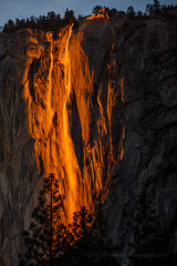
A happy Valentine's Day: February 14, 2017, Yosemite National Park
Horsetail Fall on Monday Night
Two flows in 2016!
Horsetail Fall in Yosemite Valley is backlit by the setting sun for roughly two weeks each year. As the sun falls behind the vertical face of El Capitan, it selectively lights this waterfall with its orange sunset glow.

This is an amazing spectacle to witness. Lasting only about 15 minutes before the sun goes down, the lighting gradually grows in intensity and color for the last 5 minutes or so. It is often like seeing a narrow strip of lava flowing down the face of El Capitan.

The weather and the water flows often don't cooperate.  You need enough snow above El Capitan, high enough temperatures up there for some of that snow to melt, and you need clear skies where the sun sets on the western horizon.  I was shut out by back to back blizzards in 2007, so I was fortunate to see this on two consecutive evenings from two different angles in 2008, and several times since then.

Different Take on Horsetail Fall
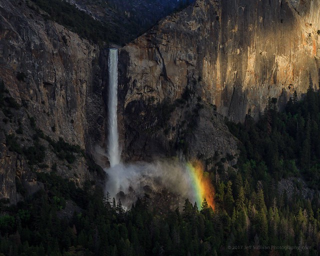
Nearly no water in 2012, it still looked great!
Sometimes there is little water flowing down the rock, but from a position to the south, the selective light on the wet spot makes it look like the waterfall is there anyway!

Other times, if there's clearly too much cloud cover or valley mist to allow light through, heading somewhere else for a more traditional landscape shot may be the ticket for that evening.  You have to first anticipate where the best light will be, before you can be in the right place to react to the light as it develops.

Horsetail Fall February 15, 2017In 2017 I experienced a new variation: there was little direct light on the waterfall at sunrise, but there was intense sunset color on the horizon a few minutes later, and while the main flow of water didn't pick that up with any particular intensity, the surrounding wet spots on the rock reflected it beautifully.

Unfortunately most photographers seemed to have been waiting only for the direct light of the sun, so there was a pulse of traffic as they drove away, probably not seeing the sunset light that developed after the official sunset time.  Folks, that's how sunsets usually work!  The best color is minutes AFTER the theoretical (zero degree horizon) sunset time. So stick around for at least 10 minutes "after sunset", or even 15 or 20, just to be sure that you don't miss that night's color, whatever it may be.
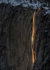
Natural Firefall (266,301 views on Flickr so far!)
February 28, 2008
1) Along the bank of the Merced River near the turnout just East of the Cathedral Beach picnic area (which is closed for Winter). This location is described on page 24 of my 320-page guidebook "Photographing California Vol. 2 - South".

This angle provides the composition that compresses the complete length of Horsetail Fall against the rock of El Capitan.  You can zoom in for a composition with no sky, or use a wider focal length to include the profile of El Capitan.  This seems to be the most crowded location in recent years, as photographers pack together to shoot through an opening in the trees.

This is arguably a more complete view of Horsetail Fall, showing a longer stretch of its descent, making it look longer and skinnier.  The view of more of the vertical drop makes the water flow look skinnier, and seeing it all from a longer distance makes it look more abstract and lava-like.

Horsetail Falls at Sunset
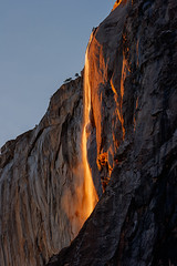
2) In the vicinity of the Cathedral picnic area on Northside Road in the valley, 1/2 mile East of the El Capitan bridge. That North road is closed for maintenance, so it's a 1 mile walk each way from where the El Captan bridge road hits Southside Road. This location is also described in "Photographing California Vol. 2 - South".

This is more of a side view than the position on the south side of the Merced River, with the upper reaches of the waterfall against the sky.  By showing less of the vertical drop, the flow of the water looks wider, and you see more of the rock face relief in detail.

The more northern location is probably the more common and iconic shot you see, although I don't mean to imply that's better.  It's just another nice variation on a rare and amazing solar alignment event.

Winter Wonderland
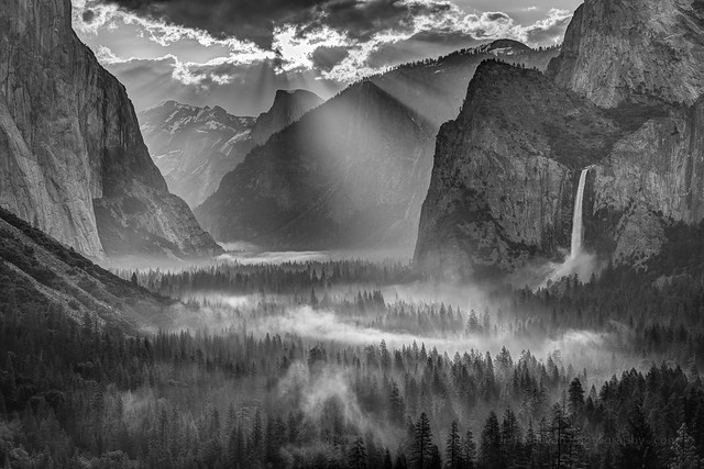
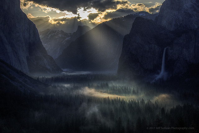
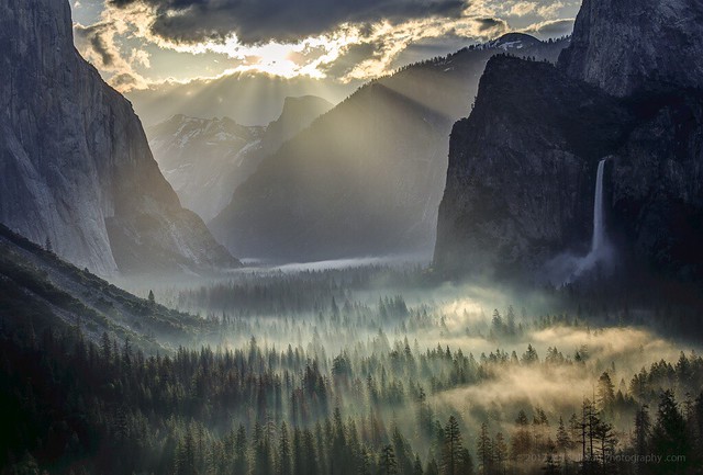
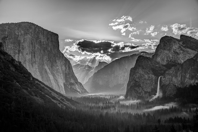
No Horsetail, 2007.  So what?
The conditions required to make Horsetail Fall are unpredictable, so it's important not to rule out all trips that look iffy.  You're probably more likely to miss it than catch it, but it's important to remember that Yosemite is beautiful this time of year, and generally more so if there are passing storms!  So missing Horsetail Fall may be the best possible outcome for your trip.  You may catch far better photos, of far more unique conditions.

Plan on some dates, prepare yourself for the trip (carry chains), enjoy a winter trip to Yosemite, and consider Horsetail Fall to be possible icing on the cake!  And expect to enjoy return trips to Yosemite in the winter if you don't get the Horsetail Fall photo that you want on the first one.  Seriously, even when I lived in Sacramento, only 3 hours away, it was nearly impossible to predict when conditions would be great.

Life isn't a destination, it's the journey that occurs as you pursue your goals.  Enjoy and make the most out of every moment.

If you want a little help maximizing your odds of success and anticipating the light to be in the right place while you are in the park, I update my annual list of Yosemite photography workshops here.

Yosemite Falls Moonlit Night Reflection
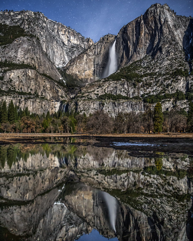
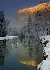
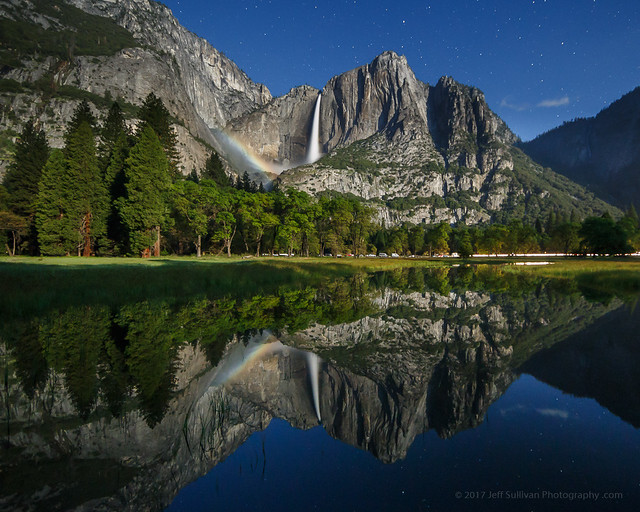
Upper Yosemite Falls reflection on a moonlit night, February 15, 2017

Monday, November 25, 2013

Yosemite National Park Photo Workshops


I'm working on workshop dates for Yosemite for 2014.  I'll post updates on my new blog when they become available: http://www.jeffsullivanphotography.com/blog/yosemite-national-park-photography-workshops/

Night Reflections in Yosemite ValleyHalf Dome over Sunrise Mist in Yosemite ValleyMoon Rise Behind Half DomeYosemite Falls in WinterStorm Cloud Reflection at Valley ViewHalf Dome, Full Moon
Winter WonderlandA Moment of PeaceThe Day Was Off To A Good StartSunset at Glacier PointSolar Rainbow in Yosemite ValleyRim Fire in Yosemite, 116mm
Fall Morning Mist in Yosemite National ParkBreak in the StormTrees and MistCathedral Beach in WinterYosemite's Rim Fire Under the CloudsFire on a Massive Scale
Under a Starry SkyRim Fire in Yosemite at 85mmYosemite Falls Moonbow Star TrailsValley View in PinkIce and Pollen in Tenaya LakeBridalveil Falls
Yosemite National Park, a set on Flickr.

Monday, August 26, 2013

Rim Fire Closes Areas of Yosemite National Park

At 10:41 am this morning Yosemite National Park distributed a map of closed areas within the park, generally north of CA-120 and east of Glen Aulin, as shown on this map:


Details of the Yosemite National Park closures may be found at:
http://www.nps.gov/yose/planyourvisit/rimfire.htm

On Twitter Cal Fire sent out a tweet on current conditions this morning at 7:35 am:

[update] near (Tuolumne County) is now 149,780 acres & 15% contained.

Cal Fire's page for incident updates is found at:
http://inciweb.org/incident/3660/

The latest Cal Fire map color-coded to show daily progress of the fire is available at:
http://inciweb.nwcg.gov/photos/CASTF/2013-08-17-1950-Rim/picts/2013_08_26-14.11.21.961-CDT.jpeg


Saturday, November 10, 2012

Moon Rise Over Half Dome in Yosemite

Moon Rise over Hall Dome, Yosemite National Park

I've been pursuing moon rises behind Half Dome for many years. The weather doesn't always cooperate, but I've caught it from several different vantage points now, and I have a few more angles to catch it from on return trips.

This time there had been a couple of light snowfalls already in the Fall, so there was a nice dusting of snow and the beginnings of ice on the lakes as I crossed Tioga Pass.  Here's Ellery Lake with Ice and patches of open water.

The light wasn't great as I passed tuolumne Meadows, but upon reaching Tenaya Lake, I found a mirror surface reflecting trees on the far side.  You could get great pictures if you moved away from the families throwing rocks into the lake, and timed your shots to avoid the worst of the ripples they created.


Next I pulled into the Olmstead Point parking lot.  I was shocked at the quantity of people crowding the area so late in October.  I didn't stop.

Then I checked a few stands of dogwood trees tucked into groves of redwood trees, and found the dogwoods brightly colored and beautifully back-lit.

Proceeding for a lap around Yosemite Valley, Upper Yosemite Fall was completely dry, missing even the modest wetness you'll often see on the rock.  Most of the deciduous trees seemed a couple of weeks behind schedule turning color, like the aspen had been in the Eastern Sierra this season.  The oaks were lightening somewhat, but not far enough along to warrant a stop by Cook's Meadow.  I did spot some trees nicely back-lit against Cathedral Rock, so I pulled over.

A large van full of photo workshop customers passed by; I figured I'd catch up with them in a few minutes, either in the turnout opposite Bridalveil Fall at Valley View, or a short while later catching the moon rise. 

Unfortunately in this dry year even spring-fed Bridalveil Fall is nearly non-existent, breaking up into a thin mist partway to the ground.  Noticing the angle of the sun, I stopped to see whether there was enough water in Bridalveil to create a rainbow in its mist.  Sure enough, the rainbow was there, and the low water of the Merced River made a perfect reflecting pool to offer creative compositions including colorful Fall foliage.  Odd that the photo workshop passed it up (perhaps they caught it the day before).

By then it was time to go set up for moon rise.  Curiously, the photography workshop was still nowhere to be found.  Had they really left the park only minutes before one of the events of the year in Yosemite? 

Last year the only other person who had anticipated the moon rise in the position I had chosen was a guy from Seattle shooting on film.  Of course once the moon rose, two or three dozen people joined us!  This year, from another location, I first met someone from Cincinnati.  As it turned out, someone had gotten the word out online, so roughly 2 dozen people more people eventually showed up (and there were apparently a few more at the vantage point I had used the prior year).  

A started one camera at 105mm focal length to capture a time-lapse video of the entire moon rise, and I used a second camera to capture the initial emergence at 400mm then the rest of the event at 200mm.  It'll take me a while to get each sequence processed, but so far it's looking good!  There are even a couple of climbers you can see move slightly in the video, on El Capitan directly opposite the moon in this image.  

I've been pretty busy this year wrapping up my guide book to California landscape photography, but I'll offer Yosemite landscape photography workshops as time permits:
http://www.jeffsullivanphotography.com/blog/yosemite-national-park-photography-workshops/

Update August 20, 2014: Thanks to the +Royal Observatory Greenwich  for including my image in their video about the Astronomy Photographer of the Year 2104 competition! 


I'm always honored to have my work recognized by the Royal Observatory in London, home of Greenwich Mean Time (GMT) and the Prime Meridian... the place that every longitude, every GPS coordinate on the planet, is defined relative to!
  See and share the video on YouTube.