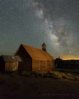
Thursday, March 31, 2016

Revelstoke: Heli-ski Capital of the World?

Revelstoke National Park, British Columbia, in September
When I passed through the picturesque town of Revelstoke, British Columbia in September, I know that it was a quaint little ski town, with world famous helicopter skiing opportunities in the surrounding mountain ranges. I had grown up seeing the Monshees and Selkirks highlighted in the ski movies by Warren Miller (now +Warren Miller Entertainment), so it was great to be seeing the place in person, a bit of a pilgrimage for a powder skier. I was pleased to find that the town hadn't been overrun with condominiums and other development, like so many other North American ski towns. It's a real town, with actual inhabitants. What a concept!

Upon arrival in town, it was nearly sunset, so I found a pond for reflections. There wasn't much beyond the sky and reflection for a subject however, so I moved to a view where I could see one of the surrounding peaks with the last light of the sun on it.

The hotel I was staying in had a lot of skiing images on the wall, so I walked around admiring them. As it turned out, it was the base for CMH, Canadian Mountain Holidays, one of the well known heli-skiing operations in town. I've skied all of my life, and I had avalanche training along with the 12-week Outdoor Emergency Care course given by the +American Red Cross when I was on the National Ski Patrol at +Squaw Valley Resort for a few years.  With ski season on the way, I was tempted to fill out a job application! Somehow I resisted the temptation. Maybe next year....

What I didn't know at the time was that my brother would be skiing in Revelstoke this winter. With the American dollar strong, he and his friends looked into dates and prices, and decided to go with +Selkirk Tangiers Heli Skiing.  I couldn't join them this time, but at least I know what I missed, via his +GoPro video from the trip:


I have to admit that I'm more than a little jealous... it's definitely a "bucket list" trip that I'd like to take sometime!

 The next day there was a dusting of snow on the surrounding mountains, but the storm was already breaking up, so it was a perfect day to head into adjacent Revelstoke National Park to enjoy the views. I was planning on heading in the general direction of Lake Louise and Banff, so I couldn't go on any long hikes.

 As it turned out, the scenery was spectacular as I headed east, and the weather kept the conditions interesting for photography, so it was a great day to be on the road. I passed a few national parks that I didn't have time to explore; I'll definitely have to allocate more time to enjoy the area on my next pass through.


#roadtrip #travel +Tourism British Columbia +Visit Canada

Weather Timelapse: Lenticular Clouds in the Eastern Sierra


A few nights ago I watched lenticular clouds form over the Three Sisters in the Sweetwater Range, across Topaz Lake on the California/Nevada border in the Eastern Sierra. It looked like a little sunset light might get through, so I took a few photographs, and set up my camera to capture a time-lapse sequence of several hundred more, so I could convert them into a video.

As the direct sunlight left the scene and the light faded towards the blue light of twilight, is looked like the cloud cover was too thick, and sunset simply wasn't going to happen.

Then a hint of orange started to appear, and brighten, at the bottom of the stack of clouds.


I reframed the image to capture detail of the evolving light over the Three Sisters.

The sunset light was brief, but intense, and the roughly 1000 photos that I took to capture the moment payed off!

I processed a few hundred of the images into a time-lapse video so you could see the whole event.  Here's the best edit I've produced so far:

Saturday, March 12, 2016

Death Valley "Super Bloom" 2016: Best Wildflower Sites

Lower Warm Spring Canyon Road from miles 1 to 3 had declined slightly... to this! Still better than a "normal" year.

Last week I repeated and expanded the complete south to north traverse of Death Valley National Park that I had scouted in February.  How were the wildflowers holding up?  What were the best locations?  The Park has been issuing detailed reports, so let's use the March 2 and February 24 reports as a baseline, and I'll illustrate current conditions with my photos.
-----

Mile Marker 42, Badwater Road
March 2, 2016

The bloom is definitely moving north and higher in altitude. Although there are still expansive fields of Desert Gold (Geraea canescens) along the Badwater Road, as well as carpets of Sand Verbena (Abronia villosa) from Mile Marker 42 to the end of the road, many of the other flowers in this area are past their peak.

My pick of the week is Highway 190. Look for the cheerful Easter egg colors of bright yellow Golden Evening Primrose (Camissonia brevipes) and purple Notchleaf Phacelia (Phacelia crenulata) from Furnace Creek to the East Park Entrance. There are pink carpets of Purple Mat (Nama demissum) in some sections. (I think this flower was misnamed!) The ethereal, floating blossoms of Gravel Ghost (Atrichoseris platyphylla) are growing thicker in this area than I've ever seen them before. Northwest of the Visitor Center, you will find the expansive fields of Desert Gold that Death Valley is famous for. All along the road, get out and look closer for more variety.

Beatty Cutoff
A nice little loop drive is to go up the Beatty Cutoff Road and down Mud Canyon, then back to Furnace Creek along Highway 190. Mud Canyon is looking fantastic, but the flowers are growing so thick there that there is nowhere to pull over. Use the wide shoulders on the Beatty Cutoff and wander a wash to look for variety.

You will find Phacelia, Golden Evening Primrose, Mohavea (Mohavea breviflora), Acton Encelia (Encelia actoni), and Broad-Flowered Gilia (Gilia latiflora) on the Scotty's Castle Road. Although there are a few flowers on the approaches to Towne Pass and in the Panamint Valley, those areas are not yet worth a special trip. If you have a high clearance vehicle, do a little botanizing in the mid-elevations of the Greenwater Valley to increase your species count. There are not a lot of flowers blooming here yet, but there are a lot of different species, flowers you will not find in the lower elevations.

Hole in the Wall (4WD road)
Best backcountry dirt road drives this week would be the Hole in the Wall Road and Echo Canyon Road. Color and diversity in both these places is fantastic. Titus Canyon has some Paintbrush (Castilleja augustifolia) and Lupine (Lupinus sp.) in the mid-elevations, and flowers are blooming in the lower reaches of the canyon, but it will still be a few weeks before the bloom really gets going here.
For hikers, Fall Canyon and Monarch Canyon are good bets.
Happy flower hunting!

Furnace Creek Wash
February 24, 2016

The bloom is moving North! Check out the great color combo of Golden Evening Primrose (Camissonia brevipes) and Notchleaf Phacelia (Phacelia crenulata) decorating Furnace Creek Wash from the East Entrance to the Furnace Creek Inn. Keep your eyes open in that stretch for expanses of Purple Mat (Nama demissum) and the rounded humps of Turtleback (Psathyrotes ramosissima). Get out of your car and take a stroll in the wash, and you may be amazed at the diversity. I was able to identify over a dozen species in a ten minute walk!

Along Highway 190 north from the Visitor Center to the Scotty's Castle Road, fields of Desert Gold (Geraea canescens) are starting to fill in the blanks. One new hotspot is the Beatty Cut-Off Road. The diversity in some places is nothing short of amazing. Try walking a wash between Mile Markers 2 and 4 to taste a bit of that diversity.If you are traveling to Ubehebe Crater or the Racetrack, the Scotty's Castle Road is adorned with the same gold and purple color scheme as the Furnace Creek Wash. Although there is not enough yet to warrant a special trip, look for expanses of Mohavia (Mohavea breviflora) , blooming Acton Encelia (Encelia actoni), and Broad Flowered Gilia (Gilia latiflora) in this stretch. Phacelia and Golden Evening Primrose are also brightening up the approaches on both sides of Towne Pass.

Badwater Road Mile Marker 30, looking back at 25
The Badwater Road is still the go-to destination for those huge expanses of endless flowers. The Brown-Eyed Evening Primroses (Camissonia claviformis) are starting to bolt due to hot temperatures and lack of rain, but the Desert Gold is still going strong, and the Gravel Ghost Atrichoseis platyphylla), Pebble Pincushion (Chaenactis carphoclinia), and Broad-Leaved Gilia (Aliciella latifolia) are just getting started. If you want those lower elevation flowers, though, you may want to come soon. I am amazed at how quickly the Phacelia and Desert Five Spot ( Erimalche rotundifolia) are working their way up their stems.

Harry Wade Road has some really nice things going on near the Amargosa River Crossing. As usual, get out of your car and walk a wash to see more varieties. Echo Canyon and Hole in the Wall should have some nice flowers. Check out the rock walls and see if you can find Death Valley Monkeyflower (Mimulus rupicola).

Greenwater Valley is REALLY green. Some flowers are starting to bloom there –I saw Fremont Phacelia (Phacelia Fremontii), Desert Dandelion (Malicothrix californica glabrata), Desert Gold Poppy (Eschscholtzia glyptosperma), Checker Fiddleneck (Amsinckia tessellate) , Blazing Star (Mentzelia sp.) and Globemallow ((Sphaeralcea ambigua) –but they are VERY few and far between still. In 2 weeks, this road will really pop.

Dante's View Road uphill from Greenwater Valley... in November!
For hikers, canyons are best for diversity. Fall Canyon is looking great, or try Willow and Sidewinder Canyons, or just wander up a likely wash.

Happy Flower Hunting!

-----

Overall the suggestions were great: accurate and with greater/longer relevance than most visitors may suspect.  By last week the intensity of the bloom had clearly declined down near Ashford Mill from my previous trip in February, but it was 1000X better than a normal year before, so if it had declined to "only" 900X as good, who cares? The opportunities were still tremendous, and well above average for Death Valley.

Alongside Badwater Road, nearly to Jubilee Pass
There's been a lot said about wind last Saturday night damaging the flowers, but again, I suspect that's relative to the mid-February conditions. We're just spoiled this year. I expect that there are plenty of wildflowers left compared to normal, and there will be plenty of exceptional pockets less affected by wind. Also, I bet that certain species such as sand verbena are designed to withstand wind (how the dunes they live in are formed). As I recall, the wind was coming from the south in the evening on Saturday, then from the north the next morning, so many canyons oriented east-west would be protected from that.

Spotted alongside CA-190 north of Furnace Creek
Anyone with a little experience with desert wildflowers and Death Valley should be able to successfully decode the puzzle and find the locations and species best under whatever conditions present themselves. Then again, with so many miles of wildflowers blooming, it's hard to go wrong, and you're bound to do well just driving through the areas highlighted on the Park's wildflower map. I found the scene to the right by the side of the road, simply driving from Furnace Creek to Beatty Junction.  So get out to Death Valley and find whatever compositions catch your eye and imagination!

For more photos, I've started a Death Valley 2016 album on my +Death Valley Workshops page, and a Death Valley iPhone 6S+ Photos album there as well.

Sunday, February 28, 2016

Bodie Night Photography Workshops 2016

It's time to kick off another year of night photography workshops in Bodie!  My June 27 workshop in Bodie is full.  The remaining  Bodie workshop dates are filling fast :

Saturday June 4 – night photography workshop: Milky Way, star trails, light painting, 6 pm - 1 am
Sunday June 5 - morning / interior access

June 27 - *FULL*

Friday, July 29 - night photography workshop: Milky Way, star trails, light painting, 6 pm - 1 am
(the night before the Saturday, July 30 Ghost Stories night).

Sunday August 28 – night photography workshop: Milky Way, star trails, light painting, 6 pm - 1 am (the night after after the Saturday, August 27 Ghost Stories night).

Saturday October 1 – morning / interior access
Saturday October 1 – night photography workshop: Milky Way, star trails, light painting, 6 pm - 1 am

We have four nights and two interior access sessions with space remaining.  Two of our Bodie nights are timed to be the night before or after a Bodie "Ghost Stories" night, when the park lets anyone stay until 10 pm with regular park admission.  That doesn't give visitors much more than sunset and twilight in the long days of summer, but it's still after-hours access, a perfect practice session before our August 28 workshop or following our July 29 workshop.The sun and stars move south to north over the course of the summer, and the Milky Way rises earlier and moves southeast to southwest from month to month.  This changes the compositions available. I've shot in Bodie at night multiple times in each month in recent years, so I have a lot of experience and composition knowledge to draw from in order to help you move efficiently around the park from shot to shot.

A discussion of the characteristics of the various dates appears on the Bodie workshop page on my new blog: http://www.jeffsullivanphotography.com/blog/bodie-night-photography-workshops/
Registration is there too: the workshops currently open for enrollment have the payment/registration linked to the price net to the description.

I'll place some examples below.  For a lot more, see nearly 400 of my Bodie photos in this album: https://www.flickr.com/photos/jeffreysullivan/albums/72157630926160354


Bodie at Night


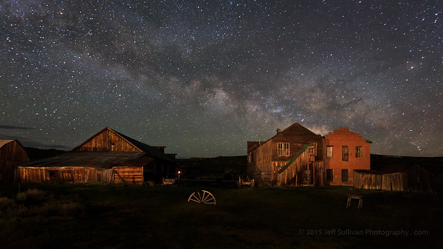
Starry Night over Bodie Church


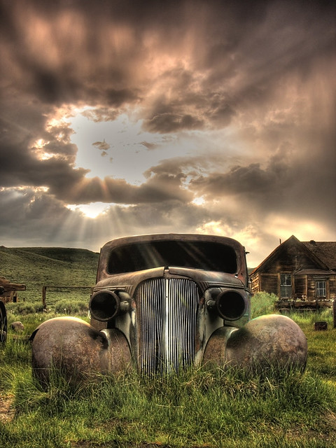
Going Nowhere Fast

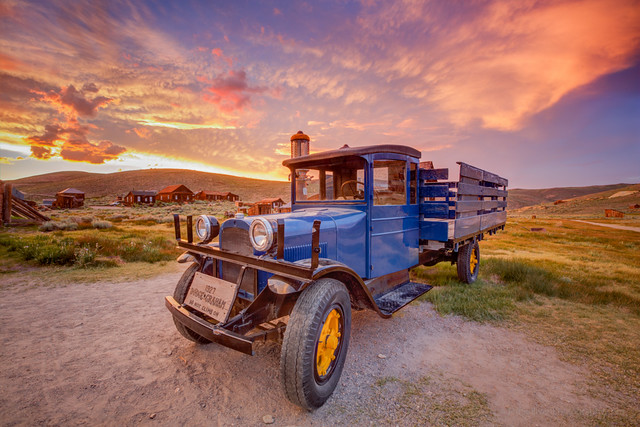
1927 Dodge Graham at Sunset

Hope you can join us!

www.JeffSullivanPhotography.com

Wednesday, February 24, 2016

The Almost Super Bloom in Death Valley

Reports are still coming in strong on the excellent wildflower bloom underway this month in Death Valley National Park. These photos are from my scouting trip through the park February 7-11.  
Desert Gold and Sand Verbena in Death Valley
Desert gold and sand verbena


As of February 9, some flowers were past prime, others were vigorous, others were just emerging.  Some rain fell a week later, which should extend the season for this year's already healthy crop.

Ashford Mill to Jubilee Pass
Looking from the Ashford Mill area toward Jubilee Pass
In spite of the hype in the media and on social media, the park is NOT calling it a "super bloom" yet, but in the recent YouTube video titled "Death Valley Exposed: Wildflowers - February 2016", park ranger Alan Van Valkenburg does imply that it has the potential, perhaps with additional rains: “If you get the chance to see a bloom in Death Valley, especially a super bloom, you should take the opportunity to see it because it could be a once in a lifetime opportunity.”

There was a less dense area of desert gold north of Furnace Creek, up to and through the Beatty Cutoff area. Most other areas were looking basically lifeless, even though they may have received a lot of rain. The timing of the rain may not have been early enough for the plants to be far along yet, and once they get going they do need additional rain to keep the growth going. Rain last week in mid-February might have helped extend the life of these areas, and the growth of others.

Overall the spring wildflowers in Death Valley are usually very sparse, and peak in March, so outside of the areas I just described, the season seemed normal: nothing much should be expected in early February. The initial bloom may or may not be followed by decent blooming elsewhere. We saw healthy growth in November in areas such as the narrow last portion of the Dantes Peak road, so we were expecting the adjacent Greenwater Valley to be going nuts when we returned in February. Instead, it looked even weaker than last year... not much going and much less promising than expected.

So in much of the park, as the initial strong bloom of desert gold fades, the situation may resemble a more normal year, where you can find wildflowers, but it requires some hunting and probably high clearance, if not 4WD.

Here are a few more photographs from my visit to supplement the ones I included in my recent trip report. I drove the park from Dumont Dunes all the way out the top at the town of Big Pine.


Desert gold extensive but thin looking north from the Salt Creek turnoff north of Furnace Creek


Not far from Ashford Mill, south of Badwater


The southern end of Harry Wade Road wasn't as productive as the north end and and the Ashford Mill area.  Many of the flowers were wilted from heat, and didn't look like they were going to last much longer, especially the brown-eyed primrose.


Fiats don't float!  Not in water, not in sand.
Unpaved roads in Death Valley are marked for high clearance or 4WD vehicles for a reason.


It's not all about the desert gold.  Look closely and you'll find dozens of species available.


Bear in mind, the park didn't just suddenly become only about wildflowers!


Miner's cabin

Monday, February 15, 2016

Spring Wildflower Conditions in Death Valley, February 2016

Desert gold and Brown-eyed evening primrose near Lower Warm Springs Road February 10

Lately there has been widespread talk about a potential "superbloom" in Death Valley in 2016, due to the current strong El Nino weather pattern affecting the West Coast.  I've been hoping for a particularly strong season, so I've scouted the park from top to bottom, November to February, to monitor what's growing where.  I approached from the south at Baker and drove through the park from south to north from February 7 - 11, entering on the high clearance Harry Wade Road near Little Dumont Dunes, crossing the Amargosa River, passing Badwater, Furnace Creek, the closed road to Scotty's Castle and exiting to the north through Joshua Flats on Big Pine Road. 
Death Valley's Ashford Mill, much better than 2015
To be clear, it is an above average bloom in that area, with dense areas of wildflowers in patches, with white brown-eyed primrose growing alongside roads and in some washes, and yellow golden evening primrose taking over in some rockier, slightly higher elevations. Purple sand verbena appears in low quantities in some sandy areas. In other areas desert gold is still the most common species, but with less dense blooming.
Many other areas of the park got a lot of rain at least once, but as we drove by Scotty's Castle for example, which suffered a flood of epic proportions, there were almost no signs of green growth. There were few signs up by Eureka Dunes either, although the area clearly received healthy rain. So areas like these either received rain late and are behind Ashford Mill in timing, on track for a bloom no sooner than late March to April or May, or they didn't get enough water after the original soaking to keep germinated plants growing in ample quantities.

Sparse but visible and welcome, near Beatty Cutoff
Thick patches, not continuous, but extending for miles


As recently reported, as of mid-February there is a very good bloom of yellow "desert gold" wildflowers near Ashford Mill, about an hour's drive south of Furnace Creek. It is better than last year's bloom there, which was much-hyped at the time, but frankly in my opinion, didn't match expectations once you arrived there. So take reports with a grain of salt. Some reports may be designed to drive park visitation, room stays and meals sold, photography workshop attendance, or in some cases wildly enthusiastic may come simply out of the media's tendency to hype anything and everything.

In the area north of Furnace Creek alongside the road (CA-190) the blooming is more widespread than last year, but so far less dense than the best locations last year. While the Desert Gold often had multiple branches and blooms in the Ashford Mill area further south, it's less tall and often has only one stalk with a single flower. From the beginning of Artist Drive looking south towards Badwater you can see desert gold, but the density is lower than in past years. There is a sparse bloom near Saratoga Springs but the flowers there were already showing signs of heat stress early last week, and they get more dense further north alongside Harry Wade Road towards Ashford Mill. There's little to nothing happening from Shoshone through Tecopa to Baker alongside CA-127. There were no obvious signs of growth north of Scottys Castle alongside Big Pine Road. Strong initial growth of plants alongside the road to Dante's View apparent back in November has not been followed by more widespread growth just down the hill at Greenwater Valley Road.

So in spite of a sufficient rainfall in many places, we have a normal situation in the broken and sporadic nature of the rainfall in the park, and the timing of follow-on rain events can further affect the health of any bloom that does come.  So while it's an above average year in many areas, it'll still be very helpful to know where to look in this massive park.  Being prepared to reach the bloom locations will be particularly important given that the park only had 700 miles of roads, 2/3 of which are unpaved.  High clearance can be very useful in Death Valley National Park, and 4WD is required to reach some of the better locations. This will be particularly true as the blooming zones move up in elevation in March and April.


So bottom line, the Ashford Mill area is worth a visit if you can get to the park now.  Enjoy generally above average conditions from there through Salt Creek, but don't expect carpets of flowers.  Other areas could see more growth later, especially if there is more rain to give plants just getting started out a boost, but with an average of only 1.93" falling near Furnace Creek in a year, that's not something we can count on, so we may be seeing peak conditions in the most-visited, lower elevations in the park.

I'll be conducting a photography workshop in Death Valley National Park from March 1 - 6, 2016.  I like to offer a more adventurous workshop to show participants many of the unique locations I've discovered while exploring the park dozens of times over the past 12 years, and while researching locations to refer people to when I started writing my "Photographing California - South" guidebook in 2010.  I've found many new locations since the editorial deadline for the Death Valley chapter of that book, so now I'm working on a dedicated Death Valley guide as well.  We may take short hikes up up to 1.5 mile each way, so figure we could walk about 4-5 miles in a day.
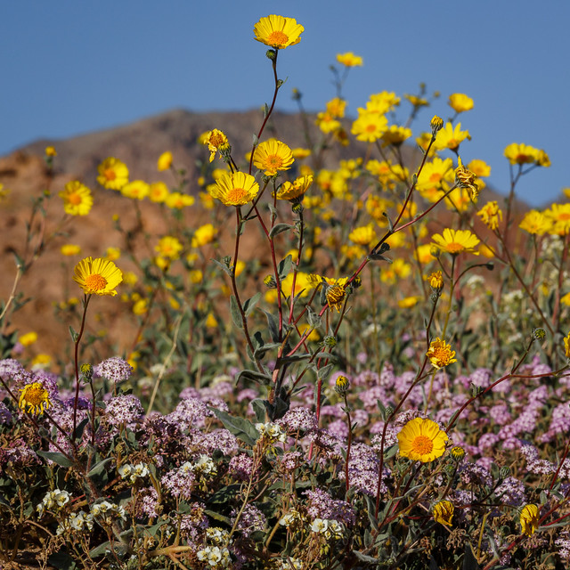
For more information on the workshop, see the Death Valley workshop page on my blog: http://www.jeffsullivanphotography.com/blog/death-valley-photography-workshop-2013/


Sand Verbena and Desert Gold Near Ashford Mill, February 9, 2016

Saturday, January 09, 2016

Top 10 Travel Photos: 2014

Milky Way rising behind the Standard Mill in Bodie, California
Continuing the retrospective look at my last decade of travel and landscape photography, 2006 - 2015, here are some of my favorites from 2014.

Sierra Crest Sunset Layers
The Minarets and Sierra Nevada at sunset
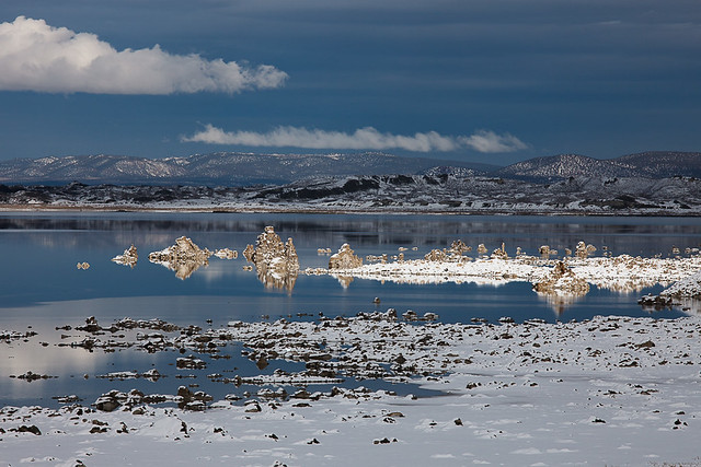
Snowy Day at Mono Lake
Mono Lake tufa rock formations selectively lit by the sun
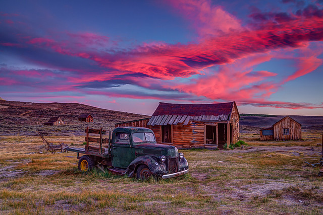
Bodie Sunset Re-edit with HDR
Sunset in Bodie State Historic Park, California
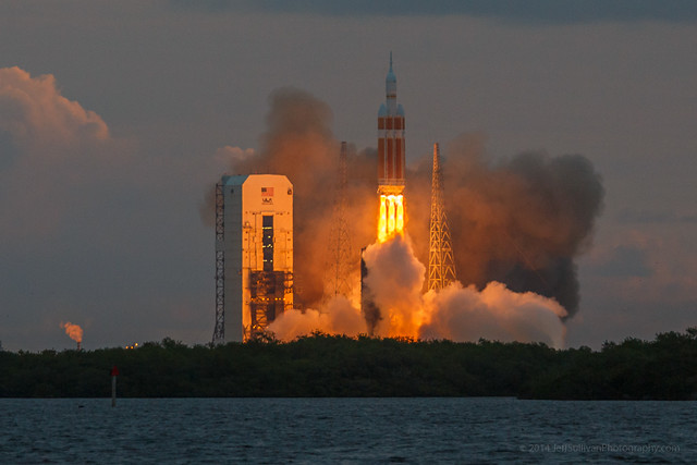
SUCCESS!
NASA's Orion EFT-1 launch at Kennedy Space Center, Florida
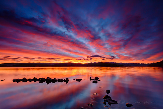
Sunrise Yesterday Morning
There's no place like home.  A rock sheep enclosure at sunrise, Topaz Lake (on the California/Nevada border).
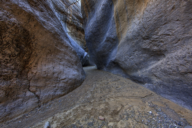
Revisting an Old Friend
One of the Death Valley slot canyons disclosed in my "Photographing California - South" guidebook
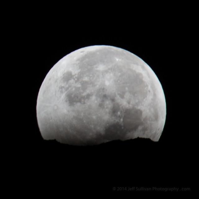
Partially Eclipsed Moon Setting, October 8, 2014
Moon setting over the Sierra Nevada, while emerging from the earth's shadow during a lunar eclipse!
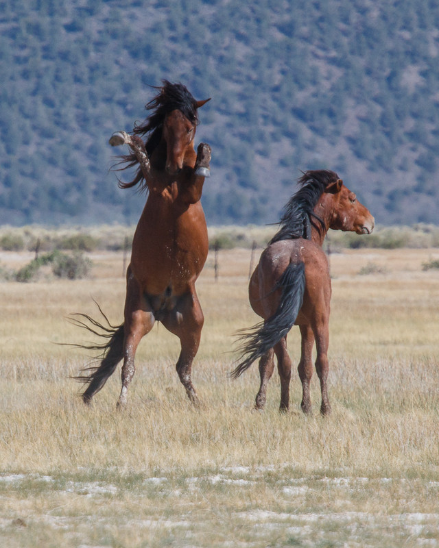
Wild Mustangs
Wild mustangs in the Eastern Sierra

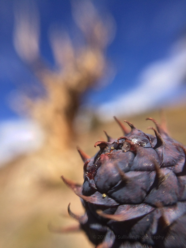
Bristlecone Pine
Playing with depth of field in the Ancient Bristlecone Pine Forest (iPhone 5S)

This was a selection of a few of my favorites from an album of over 45 photos from 2013, so there are many more that you might prefer over these. To see more of them, click on the link or album photo below.

More of my favorite photos from 2014:
https://www.flickr.com/photos/jeffreysullivan/albums/72157650285822751

2014 Favorites