Showing posts with label Death Valley. Show all posts

Monday, May 02, 2016

April Road Trip to Death Valley

Natural Bridge
You may have noticed that I'm obsessed with death. Death Valley National Park, that is! I grew up in New England, just about as far from the desert as you can get in America, so in my current quest to explore the largest national park in the Lower 48 States, I must be making up for lost time. 

Mesquite Flat Dunes
Fortunately, currently living in the nearby Eastern Sierra region, I'm only 3-4 hours from a couple of park entrances, so I can indulge in my desert yearnings frequently. I usually visit once or twice in the Thanksgiving to New Year's Day time period, then again in February and March as the wildflowers start to bloom. But as spring continues and Death Valley starts to really warm up, I like looking for storms and bouts of cooler weather, in case I can slip one or two more visits in before it gets too hot. 

In April 2016 I could see a storm front approaching in the weather forecast. Daytime high temperatures would drop into the 80s.  I'm currently working on a detailed photographer's travel guide to the park to be offered in the +SNAPP Guides app, so I threw my camera and camping gear into the car, and headed to the park with a list of the sites I wanted to explore or revisit next.

I hiked to a natural bridge, and enjoyed great views with sunlight streaming through clouds. I explored stone-walled buildings at an old mining town site, and found wildflowers thriving at higher elevations than on past visits this year.

I met a Subaru coming out the wrong way from Titus Canyon, apparently deciding that "high clearance" meant higher then they had. The worst part of the road is about halfway through the 24-mile loop, so drivers that wait that long have a lot of wrong-way driving to do. Sometimes they're in a hurry to get out, so they come flying around blind turns!

On the edge of a canyon, two jets saw me with my camera, so they took two passes each direction up the canyon, turning and shooting up sharply right in front of me, so I was able to get some great shots. They were very fast, very close, and very loud!

In Salt Creek, the water was slightly higher than normal, so the pupfish were exploring down to the parking lot, feeding in the flooded margins before low water forced them back into their normal cramped habitat space. Normally they're a little skittish, but their quest for food prevailed, so when I held my iPhone out over the water, one came over and posed for a portrait.

On one evening, I caught a sandstorm over Mesquite Flat Dunes, back-lit with golden sunlight by the setting sun.

On the way home, sunset light was lighting up rain showers at Mono Lake. It was an eventful and productive trip. I can't wait to return!  In the meantime, I've uploaded the latest batch of photos to the Death Valley 2016 photo album on my +Death Valley Workshops page on Google+.

If you might like to join me in Death Valley sometime, my spring 2016 workshops are done for the season, but I can add a session in mid-December if there's sufficient interest: Death Valley Photography Workshops.

Jellyfish Cloud
Sunset rain showers over Mono Lake

Wednesday, April 20, 2016

Photograph Jets Up Close in Death Valley

High Speed Selfie
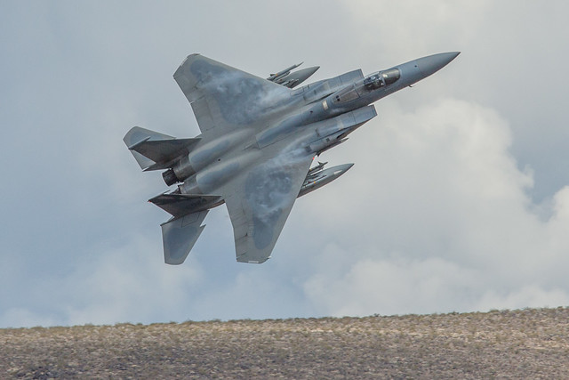
Water vapor condenses on the wing of an F-15C from the 144th Fighter Wing of the +Air National Guard in Fresno
I've encountered jets in this canyon in Death Valley by coincidence a few times over the years, so I mentioned them on page 130 of my "Photographing California" guidebook, but I've only recently sat around and waited for them to arrive. The first time I showed up at 4:30 pm and waited for a couple of hours, and was skunked. I later talked to someone who had arrived at 3:30 pm, and saw three passes in 45 minutes before leaving at 4:15 pm.
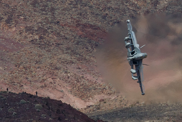
The second time I waited from dawn, nothing happened until a single plane went through at 9:50 am. Nothing happened for another hour, then a pair of F-15C jets from the California +Air National Guard went through it in each direction, twice! They seemed to spot the camera on the first run, then on the next three runs the lead plane pulled up sharply right at my location partway down the canyon, to be pulling a lot of Gs and turning up out of the canyon sharply directly next to me. The pilot appears to be looking at the camera each time, and I can't think of many reasons to end a run up the canyon early, in both directions, so it sure seemed like he was setting up selfies. When he was pulling the most Gs, water vapor trails formed as trailing lines in the wingtip vortices, and more vapor formed on top of the wings. Having heard that photographers fly over from Europe to spend a week sitting all day waiting for the jets, and they report 7 to 9 per day, I had my 9 and figured that I had done well. For some reason, Mondays were considered to be less promising, so I might not see any more planes that day. I picked up my tripods and started moving towards the car, and more planes came! It was like that until I had to leave by noon. I'd throw the tripod over my shoulder and another jet would come. A couple of guys from the adjacent campsite in the Stovepipe Wells campground the night before showed up and saw a jet go through. A few random people watched one go by from time to time. A busload of children on a field trip showed up, their wait was no more than 10 minutes, then a jet went by and they left. It seemed as if perhaps they came from a town nearby and had been able to coordinate with the pilot, perhaps a parent of one of the children. Having been skunked on a prior visit then rewarded with a flurry of activity after a few hours of boredom, I can't make generalizations yet about your odds of catching jets flying up canyons in Death Valley, but apparently if you are persistent enough, they may eventually come. That's when you'll find success, when preparation meets opportunity.

F-18 Showing Off
Water vapor condenses at the wingtips and over the wings of an F-18 in a high-G turn

Saturday, March 12, 2016

Death Valley "Super Bloom" 2016: Best Wildflower Sites

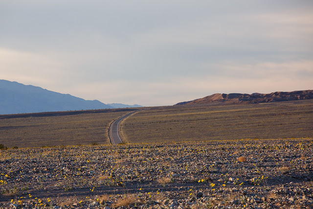
Lower Warm Spring Canyon Road from miles 1 to 3 had declined slightly... to this! Still better than a "normal" year.

Last week I repeated and expanded the complete south to north traverse of Death Valley National Park that I had scouted in February.  How were the wildflowers holding up?  What were the best locations?  The Park has been issuing detailed reports, so let's use the March 2 and February 24 reports as a baseline, and I'll illustrate current conditions with my photos.
-----

Mile Marker 42, Badwater Road
March 2, 2016

The bloom is definitely moving north and higher in altitude. Although there are still expansive fields of Desert Gold (Geraea canescens) along the Badwater Road, as well as carpets of Sand Verbena (Abronia villosa) from Mile Marker 42 to the end of the road, many of the other flowers in this area are past their peak.

My pick of the week is Highway 190. Look for the cheerful Easter egg colors of bright yellow Golden Evening Primrose (Camissonia brevipes) and purple Notchleaf Phacelia (Phacelia crenulata) from Furnace Creek to the East Park Entrance. There are pink carpets of Purple Mat (Nama demissum) in some sections. (I think this flower was misnamed!) The ethereal, floating blossoms of Gravel Ghost (Atrichoseris platyphylla) are growing thicker in this area than I've ever seen them before. Northwest of the Visitor Center, you will find the expansive fields of Desert Gold that Death Valley is famous for. All along the road, get out and look closer for more variety.

Beatty Cutoff
A nice little loop drive is to go up the Beatty Cutoff Road and down Mud Canyon, then back to Furnace Creek along Highway 190. Mud Canyon is looking fantastic, but the flowers are growing so thick there that there is nowhere to pull over. Use the wide shoulders on the Beatty Cutoff and wander a wash to look for variety.

You will find Phacelia, Golden Evening Primrose, Mohavea (Mohavea breviflora), Acton Encelia (Encelia actoni), and Broad-Flowered Gilia (Gilia latiflora) on the Scotty's Castle Road. Although there are a few flowers on the approaches to Towne Pass and in the Panamint Valley, those areas are not yet worth a special trip. If you have a high clearance vehicle, do a little botanizing in the mid-elevations of the Greenwater Valley to increase your species count. There are not a lot of flowers blooming here yet, but there are a lot of different species, flowers you will not find in the lower elevations.

Hole in the Wall (4WD road)
Best backcountry dirt road drives this week would be the Hole in the Wall Road and Echo Canyon Road. Color and diversity in both these places is fantastic. Titus Canyon has some Paintbrush (Castilleja augustifolia) and Lupine (Lupinus sp.) in the mid-elevations, and flowers are blooming in the lower reaches of the canyon, but it will still be a few weeks before the bloom really gets going here.
For hikers, Fall Canyon and Monarch Canyon are good bets.
Happy flower hunting!

Furnace Creek Wash
February 24, 2016

The bloom is moving North! Check out the great color combo of Golden Evening Primrose (Camissonia brevipes) and Notchleaf Phacelia (Phacelia crenulata) decorating Furnace Creek Wash from the East Entrance to the Furnace Creek Inn. Keep your eyes open in that stretch for expanses of Purple Mat (Nama demissum) and the rounded humps of Turtleback (Psathyrotes ramosissima). Get out of your car and take a stroll in the wash, and you may be amazed at the diversity. I was able to identify over a dozen species in a ten minute walk!

Along Highway 190 north from the Visitor Center to the Scotty's Castle Road, fields of Desert Gold (Geraea canescens) are starting to fill in the blanks. One new hotspot is the Beatty Cut-Off Road. The diversity in some places is nothing short of amazing. Try walking a wash between Mile Markers 2 and 4 to taste a bit of that diversity.If you are traveling to Ubehebe Crater or the Racetrack, the Scotty's Castle Road is adorned with the same gold and purple color scheme as the Furnace Creek Wash. Although there is not enough yet to warrant a special trip, look for expanses of Mohavia (Mohavea breviflora) , blooming Acton Encelia (Encelia actoni), and Broad Flowered Gilia (Gilia latiflora) in this stretch. Phacelia and Golden Evening Primrose are also brightening up the approaches on both sides of Towne Pass.

Badwater Road Mile Marker 30, looking back at 25
The Badwater Road is still the go-to destination for those huge expanses of endless flowers. The Brown-Eyed Evening Primroses (Camissonia claviformis) are starting to bolt due to hot temperatures and lack of rain, but the Desert Gold is still going strong, and the Gravel Ghost Atrichoseis platyphylla), Pebble Pincushion (Chaenactis carphoclinia), and Broad-Leaved Gilia (Aliciella latifolia) are just getting started. If you want those lower elevation flowers, though, you may want to come soon. I am amazed at how quickly the Phacelia and Desert Five Spot ( Erimalche rotundifolia) are working their way up their stems.

Harry Wade Road has some really nice things going on near the Amargosa River Crossing. As usual, get out of your car and walk a wash to see more varieties. Echo Canyon and Hole in the Wall should have some nice flowers. Check out the rock walls and see if you can find Death Valley Monkeyflower (Mimulus rupicola).

Greenwater Valley is REALLY green. Some flowers are starting to bloom there –I saw Fremont Phacelia (Phacelia Fremontii), Desert Dandelion (Malicothrix californica glabrata), Desert Gold Poppy (Eschscholtzia glyptosperma), Checker Fiddleneck (Amsinckia tessellate) , Blazing Star (Mentzelia sp.) and Globemallow ((Sphaeralcea ambigua) –but they are VERY few and far between still. In 2 weeks, this road will really pop.

Dante's View Road uphill from Greenwater Valley... in November!
For hikers, canyons are best for diversity. Fall Canyon is looking great, or try Willow and Sidewinder Canyons, or just wander up a likely wash.

Happy Flower Hunting!

-----

Overall the suggestions were great: accurate and with greater/longer relevance than most visitors may suspect.  By last week the intensity of the bloom had clearly declined down near Ashford Mill from my previous trip in February, but it was 1000X better than a normal year before, so if it had declined to "only" 900X as good, who cares? The opportunities were still tremendous, and well above average for Death Valley.

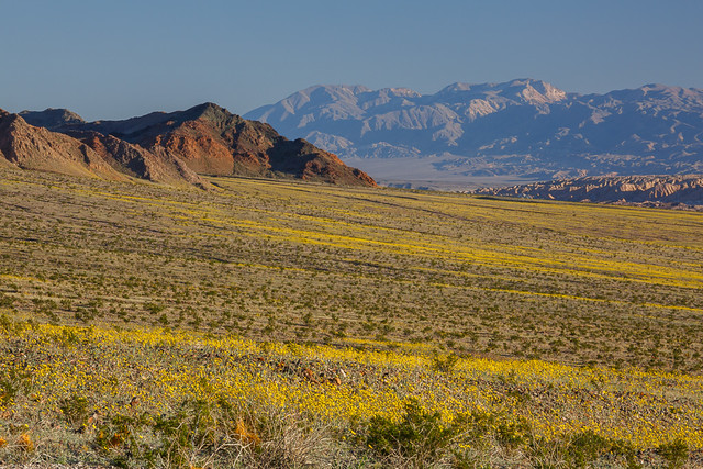
Alongside Badwater Road, nearly to Jubilee Pass
There's been a lot said about wind last Saturday night damaging the flowers, but again, I suspect that's relative to the mid-February conditions. We're just spoiled this year. I expect that there are plenty of wildflowers left compared to normal, and there will be plenty of exceptional pockets less affected by wind. Also, I bet that certain species such as sand verbena are designed to withstand wind (how the dunes they live in are formed). As I recall, the wind was coming from the south in the evening on Saturday, then from the north the next morning, so many canyons oriented east-west would be protected from that.

Spotted alongside CA-190 north of Furnace Creek
Anyone with a little experience with desert wildflowers and Death Valley should be able to successfully decode the puzzle and find the locations and species best under whatever conditions present themselves. Then again, with so many miles of wildflowers blooming, it's hard to go wrong, and you're bound to do well just driving through the areas highlighted on the Park's wildflower map. I found the scene to the right by the side of the road, simply driving from Furnace Creek to Beatty Junction.  So get out to Death Valley and find whatever compositions catch your eye and imagination!

For more photos, I've started a Death Valley 2016 album on my +Death Valley Workshops page, and a Death Valley iPhone 6S+ Photos album there as well.

Wednesday, February 24, 2016

The Almost Super Bloom in Death Valley

Reports are still coming in strong on the excellent wildflower bloom underway this month in Death Valley National Park. These photos are from my scouting trip through the park February 7-11.  
Desert Gold and Sand Verbena in Death Valley
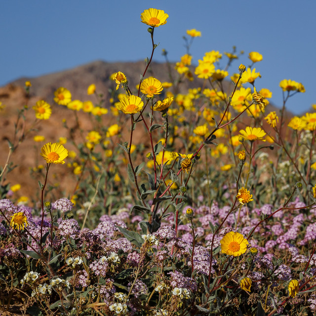
Desert gold and sand verbena


As of February 9, some flowers were past prime, others were vigorous, others were just emerging.  Some rain fell a week later, which should extend the season for this year's already healthy crop.

Ashford Mill to Jubilee Pass
Looking from the Ashford Mill area toward Jubilee Pass
In spite of the hype in the media and on social media, the park is NOT calling it a "super bloom" yet, but in the recent YouTube video titled "Death Valley Exposed: Wildflowers - February 2016", park ranger Alan Van Valkenburg does imply that it has the potential, perhaps with additional rains: “If you get the chance to see a bloom in Death Valley, especially a super bloom, you should take the opportunity to see it because it could be a once in a lifetime opportunity.”

There was a less dense area of desert gold north of Furnace Creek, up to and through the Beatty Cutoff area. Most other areas were looking basically lifeless, even though they may have received a lot of rain. The timing of the rain may not have been early enough for the plants to be far along yet, and once they get going they do need additional rain to keep the growth going. Rain last week in mid-February might have helped extend the life of these areas, and the growth of others.

Overall the spring wildflowers in Death Valley are usually very sparse, and peak in March, so outside of the areas I just described, the season seemed normal: nothing much should be expected in early February. The initial bloom may or may not be followed by decent blooming elsewhere. We saw healthy growth in November in areas such as the narrow last portion of the Dantes Peak road, so we were expecting the adjacent Greenwater Valley to be going nuts when we returned in February. Instead, it looked even weaker than last year... not much going and much less promising than expected.

So in much of the park, as the initial strong bloom of desert gold fades, the situation may resemble a more normal year, where you can find wildflowers, but it requires some hunting and probably high clearance, if not 4WD.

Here are a few more photographs from my visit to supplement the ones I included in my recent trip report. I drove the park from Dumont Dunes all the way out the top at the town of Big Pine.


Desert gold extensive but thin looking north from the Salt Creek turnoff north of Furnace Creek


Not far from Ashford Mill, south of Badwater


The southern end of Harry Wade Road wasn't as productive as the north end and and the Ashford Mill area.  Many of the flowers were wilted from heat, and didn't look like they were going to last much longer, especially the brown-eyed primrose.


Fiats don't float!  Not in water, not in sand.
Unpaved roads in Death Valley are marked for high clearance or 4WD vehicles for a reason.


It's not all about the desert gold.  Look closely and you'll find dozens of species available.


Bear in mind, the park didn't just suddenly become only about wildflowers!


Miner's cabin

Monday, February 15, 2016

Spring Wildflower Conditions in Death Valley, February 2016

Desert gold and Brown-eyed evening primrose near Lower Warm Springs Road February 10

Lately there has been widespread talk about a potential "superbloom" in Death Valley in 2016, due to the current strong El Nino weather pattern affecting the West Coast.  I've been hoping for a particularly strong season, so I've scouted the park from top to bottom, November to February, to monitor what's growing where.  I approached from the south at Baker and drove through the park from south to north from February 7 - 11, entering on the high clearance Harry Wade Road near Little Dumont Dunes, crossing the Amargosa River, passing Badwater, Furnace Creek, the closed road to Scotty's Castle and exiting to the north through Joshua Flats on Big Pine Road. 
Death Valley's Ashford Mill, much better than 2015
To be clear, it is an above average bloom in that area, with dense areas of wildflowers in patches, with white brown-eyed primrose growing alongside roads and in some washes, and yellow golden evening primrose taking over in some rockier, slightly higher elevations. Purple sand verbena appears in low quantities in some sandy areas. In other areas desert gold is still the most common species, but with less dense blooming.
Many other areas of the park got a lot of rain at least once, but as we drove by Scotty's Castle for example, which suffered a flood of epic proportions, there were almost no signs of green growth. There were few signs up by Eureka Dunes either, although the area clearly received healthy rain. So areas like these either received rain late and are behind Ashford Mill in timing, on track for a bloom no sooner than late March to April or May, or they didn't get enough water after the original soaking to keep germinated plants growing in ample quantities.

Sparse but visible and welcome, near Beatty Cutoff
Thick patches, not continuous, but extending for miles


As recently reported, as of mid-February there is a very good bloom of yellow "desert gold" wildflowers near Ashford Mill, about an hour's drive south of Furnace Creek. It is better than last year's bloom there, which was much-hyped at the time, but frankly in my opinion, didn't match expectations once you arrived there. So take reports with a grain of salt. Some reports may be designed to drive park visitation, room stays and meals sold, photography workshop attendance, or in some cases wildly enthusiastic may come simply out of the media's tendency to hype anything and everything.

In the area north of Furnace Creek alongside the road (CA-190) the blooming is more widespread than last year, but so far less dense than the best locations last year. While the Desert Gold often had multiple branches and blooms in the Ashford Mill area further south, it's less tall and often has only one stalk with a single flower. From the beginning of Artist Drive looking south towards Badwater you can see desert gold, but the density is lower than in past years. There is a sparse bloom near Saratoga Springs but the flowers there were already showing signs of heat stress early last week, and they get more dense further north alongside Harry Wade Road towards Ashford Mill. There's little to nothing happening from Shoshone through Tecopa to Baker alongside CA-127. There were no obvious signs of growth north of Scottys Castle alongside Big Pine Road. Strong initial growth of plants alongside the road to Dante's View apparent back in November has not been followed by more widespread growth just down the hill at Greenwater Valley Road.

So in spite of a sufficient rainfall in many places, we have a normal situation in the broken and sporadic nature of the rainfall in the park, and the timing of follow-on rain events can further affect the health of any bloom that does come.  So while it's an above average year in many areas, it'll still be very helpful to know where to look in this massive park.  Being prepared to reach the bloom locations will be particularly important given that the park only had 700 miles of roads, 2/3 of which are unpaved.  High clearance can be very useful in Death Valley National Park, and 4WD is required to reach some of the better locations. This will be particularly true as the blooming zones move up in elevation in March and April.


So bottom line, the Ashford Mill area is worth a visit if you can get to the park now.  Enjoy generally above average conditions from there through Salt Creek, but don't expect carpets of flowers.  Other areas could see more growth later, especially if there is more rain to give plants just getting started out a boost, but with an average of only 1.93" falling near Furnace Creek in a year, that's not something we can count on, so we may be seeing peak conditions in the most-visited, lower elevations in the park.

I'll be conducting a photography workshop in Death Valley National Park from March 1 - 6, 2016.  I like to offer a more adventurous workshop to show participants many of the unique locations I've discovered while exploring the park dozens of times over the past 12 years, and while researching locations to refer people to when I started writing my "Photographing California - South" guidebook in 2010.  I've found many new locations since the editorial deadline for the Death Valley chapter of that book, so now I'm working on a dedicated Death Valley guide as well.  We may take short hikes up up to 1.5 mile each way, so figure we could walk about 4-5 miles in a day.

For more information on the workshop, see the Death Valley workshop page on my blog: http://www.jeffsullivanphotography.com/blog/death-valley-photography-workshop-2013/


Sand Verbena and Desert Gold Near Ashford Mill, February 9, 2016

Wednesday, August 27, 2014

Racetrack "Sailing Stones" Witnessed... Mystery Solved!

"Sailing stone" on the Racetrack, Death Valley
In one of the enduring mysteries of the world, people have long wondered how rocks move across a horizontal dry lake bed surface in Death Valley National Park.

People have offered a variety of theories on how the rocks moved, with the first scientific study in 1948 suggesting dust devils.

More recently, high winds were suggested:

Using Differential GPS to Map the "Sliding" Rocks of Racetrack Playa
"So the evidence suggests that strong gusts of wind and swirling dust devils, in combination with a slick playa surface may set even the heaviest the rocks in motion. Off they go, scooting along downwind until friction slows them down and they come to rest. There the stones wait for the next time when slippery mud and wind spur them into action again." http://www.profsurv.com/magazine/article.aspx?i=769#sthash.WI0c906F.dpuf

In 2008 Ralph Lorenz of Johns Hopkins University proposed that the rocks moved when embedded in bouyant "ice cakes", as had been witnessed in tidal areas in the arctic.
"The stones partially embedded in the floating ice rise slightly above the bottom with the increasing level of water. Both the friction between the ice and water and between the stones and the bed are very small, so that blowing wind with some intensity pushes the ice (and the rocks embedded). If the stones and mud at the bottom have a light touch, the dragged stones leave a trail that remains once the ice has melted and the water has evaporated." http://blogs.egu.eu/gsoil/2013/08/26/ladies-and-gentlemen-the-rolling-stones/

Would magically energetic rocks look like this when moving?
Having seen many of the prior theories, I offered the following explanation on April 1, 2010:
"Their secret... an internal power source!  They glow as they move.  Who knew?"

My April Fools Day theory didn't gain much traction. It was fun to illustrate though!

Fortunately there were some much more serious people working on the case, so on December 21, 2013, Richard and James Norris were present to see standing water frozen on the lake bed, and to see and hear the ice cracking as the ice started to melt, then wind blew the ice sheet with the rocks embedded.  You can read the full account in today's story in the +Los Angeles Times:

Mystery of how rocks move across Death Valley lake bed solved
http://www.latimes.com/local/lanow/la-me-ln-rocks-move-death-valley-lake-bed-20140827-story.html

I had actually predicted that mode of movement after reading an article on the stones in +National Geographic seven years ago, as I mentioned in this comment on +Flickr:
"I don't believe that 700 pound rocks can move by wind alone; I think they need to be trapped in floating ice, melting along the shore, that far outweighs them and which also catches the wind. Even the heaviest rocks are inconsequential when a solid lake surface that weighs many tons starts shifting in the wind."

I didn't exactly run up there to photograph it... Ice, high winds, while access to the area may be limited, what's not to like about that?   There are some good reasons why no one has been there to see it!


Z truth is out there...
Now that the mystery is solved, will this end the pilgrimage of people wanting to see these rocks, now that the mystery is gone?  The National Park Service worries that the news may actually increase traffic.

Will the end to the mystery stop people from stealing the rocks, with the hope that they have magical powers?

Of course not.  The proposal that the rocks don't have magical powers could simply be a government cover-up, right?  The sale of tinfoil hats to Death Valley visitors will be greater than ever.

Update 7 pm:
Here's a video which includes a sequence showing a rock moving.  Jump forward to 2:58 if you want to go straight there:

Saturday, December 18, 2010

Light Painting Photo Featured on Flickr's Blog

http://blog.flickr.net/en/2010/12/16/your-best-shot-2010-painting-with-light/

This light painting was featured on Flickr's blog along with several others to celebrate the best photos of 2010.  Welcome Flickr blog readers, and thank you Flickr!

This image was created on the Badwater salt flats in Death Valley National Park. I had a flashlight with three colors of LED light. During this single 30 second exposure I lit each color for close to 10 seconds while waving my arm around up and down (which traces a sphere, like a pumpkin).

The Badwater salt flats are particularly good for light painting, since there's minimal light pollution and the white surface reflects light well.

Death Valley offers a number of interesting landscapes for light painting... go explore!

Tuesday, November 24, 2009

In A Sea Of Dunes


In A Sea Of Dunes, originally uploaded by Jeff Sullivan.

Another day, another playground made of sand. A playground for kids (young and old), a playground for photographers. Let the play begin!


Monday, November 23, 2009

Mesquite Flat Dunes


Mesquite Flat Dunes, originally uploaded by Jeff Sullivan.

The extensive dune field near Stovepipe Wells is by far the most heavily visited sand dune complex within Death Valley National Park, but even here you can find great views within a few short steps of the parking lot.


Sunday, November 22, 2009

Return to Death Valley


Walking The Ridgeline, originally uploaded by Jeff Sullivan.

The last time I took my kids to Death Valley, we had a list of places we wanted to visit, so although we had a blast on the Eureka Dunes, we had to leave before we reached the top so we could make it to The Racetrack in time for sunset.

This time we had no such agenda, so we took our sweet time wherever we went, and thoroughly enjoyed each stop. I've been to the Eureka Dunes several times, and I've captured some nice landscape images, but I really like capturing people on the dunes. We're really small in comparison, and even our footprints are nothing more than temporary intrusions. The dunes themselves often take on sinuous shapes, and the lighting of the sun can enhance our perception of the subtle curves.

The forgiving nature of the soft sand also invites playful interaction via rolling, jumping, rolling and sliding across it. The Eureka Dunes are closed to skiing and sand boarding due to several endangered species that exist only on this one dune field, but I'll definitely consider taking old ski gear with me to the other dunes in Death Valley. Life too short to avoid playing with gravity!