Showing posts with label Spring. Show all posts

Friday, May 27, 2016

Eastern Sierra Conditions Spring 2016


The aspen trees are starting to leaf out
My early May blog post on spring Eastern Sierra conditions contained a collection of possible outcomes and opportunities for spring.  I've been out a few times since then, checking the emergence status of various wildflowers, the water level at Mono Lake tufa sites (and their muddiness, since they form over springs), unpaved road access conditions, snow levels and lake iceout conditions around Tioga Pass, pond water levels and reflection opportunities in Yosemite's Tuolumne Meadows, bird and wildlife photography opportunities, and so on.

A quick snapshot on my iPhone 6S+ - good enough to show the arrowleaf balsamroot starting to bloom

Wildflowers vary in intensity and timing from year to year, which is why I do these scouting trips before the workshop, and not while dragging customers around.  Even knowing where various species can be prolific, checking the current year's status and timing involves many less than fully productive searches.  Wild iris seemed to be a bit behind in timing.  Mules ears have been starting to emerge over the past 2 weeks, and could peak in the next week or two.  The few days of clearer, warmer weather in the forecast early next week could help them along.  Paintbrush was doing well at low elevations but it is too early to tell how prolific it'll be at mid to high altitudes.  Lupine were healthy in some areas and should still be available for another week or more a lower altitudes, and emerging at mid altitudes.  Wild peach has been strong, and yellow bitterbrush has bloomed as enthusiastically as many local residents can remember (one even mentioned that this native must be a new invasive species), but the peak is now past for both.  Isolated patches offered a variety of other species, sometimes dense, but you really have to search for them.  I'll be back out over the next few days to see if some of the patches have increased in intensity, enough to warrant a visit during the upcoming workshop.

All of the photos in this post are from May 2016


The weather has been unsettled, great for daytime photography as but less conducive for many types of night photography.  That's pretty typical for May, which is one reason why I only ran a couple of Bodie night photography workshops then, but currently focus more on June and later.

Some locations are on the wet and muddy side, not unsurprising for spring, but certainly good to know before you show up for a sunrise or sunset and can't access the compositions that you might have enjoyed in the past, in summer, fall, or simply a drier year.  In other cases, a site might be more dependent upon long term trends, and the long term drought continues to provide cracked earth foregrounds.  If you're shooting in one basin and the weather and light looks like it might be better 25 miles north or south, you can save an hour of driving if you know that the site that you have in mind isn't in great condition that week.  Conversely, you can make your day, week or month if you know that a site is in great shape, and you arrive to find great light to complement the site's full potential.  A good workshop is made great when you can "connect the dots" to consistently arrive at a series of good sites, in great seasonal condition, offering optimal lighting, while reacting to the day's weather conditions.  There are no guarantees in landscape photography, and that's part of what makes it exciting, but scouting trips do resolve what would otherwise be unknowns in the mix, increasing the odds of everything coming together just right.

A quick iPhone snapshot is good enough to record conditions, break out the DSLR upon returning in better light


The somewhat early opening of Tioga Pass is not surprising given a fairly dry month of February and the winter's overall normal to low snowpack (93% in the Mammoth lakes area, closer to 100% north of Tioga Pass).  It has re-closed at times as moisture causes afternoon and evening storms, but it's open again now.  Lakes are in various stages of losing their ice.  Tenaya Lake was clear by the time the pass opened, Ellery may be completely clear now, Tioga was mostly frozen last week, so it may still hold some ice into next week.  The terrain is complicated up in that area, so having spent many sunrises and sunsets up in that area is important to knowing what is likely to be productive, vs. a bust.

Tuolumne Meadows currently offers a lot of seasonal ponds.  Determining ahead of time which of them provide decent compositions at current water levels helps keep the workshop moving efficiently.  Many workshop leaders spend a lot of time and money marketing, and do a great job filling their workshops.  Good for them.  I prefer to spend my time in the field, develop extensive site and condition knowledge, and over time earn the reputation for delivering great opportunities and results.

It's important to me for my knowledge to include photographic technique and post-processing skill.  Anyone can apply a filter in post-processing software or use a certain technique to make a landscape look wacky, and there's nothing whatsoever wrong with that, it it's the style someone chooses, rather than is trapped into through less than optimal exposure technique or lack of alternate post-processing workflow options.  Getting through the end-to-end digital photographic process with realistic results is like walking a tightrope: bay far the easiest thing to do is to fall off.  There are subtle things you can do all along the way to optimize results.  You don't need the latest camera or software, it's more about fine tuning the various steps.

Backlit storm clouds at night


Ansel Adams produced timeless results by producing heavily manipulated but seamlessly realistic results, while popular trends included hand-tinting photographs to add color.  Most of us don't know the names of his contemporaries today.  No doubt Ansel could have had great commercial success producing those colorized postcards, but any era's hot trends can look cartoonish years later, out of the unique social context of the time.  We're not immune from that today: I have over-saturated digital photos from the mid-2000s, tonemapped HDRs from the late 2000s, and I've dabbled with luminance masking, color light painting, and lately software filters.  I gravitate more realistic results, and for the experiments with various trends, I'm gradually re-processing many of the more over-the-top post processing results.  It's useful to try a range of things to settle on your own preferred style, and to continue to try new things for variety and to see if you want to broaden your options for post-processing any given scene in the future.  So I want to maintain a broad enough collection of experiences to be prepared to help photographers who want to expand their own skills.

While the goal of my pre-workshop explorations are mainly to visit locations to assess conditions, it'll be a fun challenge to line up the sites for great light and weather during the workshop next week.

iPhone 6S+ panorama


With the storms in the past weeks I haven't been out for night photography as much as I would like, but we should have a great time in Bodie June 4/5, and I hope to be out a few times in the coming nights to assess a few new locations as well.

Starry Night over Bodie Church

Sunday, April 03, 2016

California Spring Wildflower Sites, April: Antelope Valley

The Mojave Desert in April
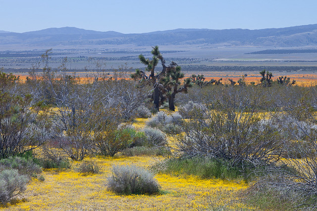
Goldfields and California poppies mix with Joshua trees in Antelope Valley near Lancaster
One of my favorite photography road trips ever was a tour of California wildflower sites in the spring, including Antelope Valley and the California State Poppy Reserve, Carrizo Plain National Monument, Figueroa Mountain Recreation Area in the +Los Padres National Forest, and the area covered by the annual Ridgecrest Wildflower Festival in the Eastern Sierra. I posted on my blog at the time some of my favorite photos from the Antelope Valley, but I have a little more time now to take a second pass and show you more of what I saw.

I'm considering taking that route again this year, so reviewing past trips and refreshing my memory on what to stop in on and check can be productive. I've also looked up the wildflower report at the California State Poppy Reserve, which posted this update on Saturday, April 2:

"The season appears to have ended early, as last month's rains came too late to sustain the bloom that had barely started. The fields are mostly grasses now; only a handful of poppies are blooming alongside the trails. The beavertail cactus in front of the visitor center is blooming, which usually happens after the season has ended- a sign that an early summer is on the way."

An early start to summer should not be entirely unexpected, given the record El Nino heat in the Pacific Ocean driving our weather pattern in recent months. It's a shame though that it didn't bring enough rain at the right time to deliver a bumper crop of wildflowers in the Antelope Valley. The Antelope Valley is large though, and there may be dispersed pockets where enough rain fell, perhaps with a northern exposure to minimize drying during the gap in winter storms in February. Much of the area is in the Mojave Desert ecosystem, where Joshua trees serve as gerat subjects, with or without wildflowers.

In any case, many other areas of Southern California desert are blooming with normal to above normal intensity, so if I decide to take the trip, the conditions in the Antelope Valley won't make or break the outcome.

So while I have my photos handy, here are a few more photos from the Antelope Valley area on that prior trip, and I'll sprinkle a few across my various social media accounts as well.


The Antelope Valley California Poppy Reserve often starts its wildflower reports in mid-March to keep visitors updated on the conditions as they peak at some point through April. The area celebrates the annual bloom at the California Poppy Festival.  This year the 25th California Poppy Festival will be held April 16-17, 2016.

For more information, I cover the Antelope Valley California State Poppy Reserve, and other sites to visit on an April California wildflower tour, on page 184 of my new 320-page guidebook, "Photographing California Vol. 2 - South (shown to the right).

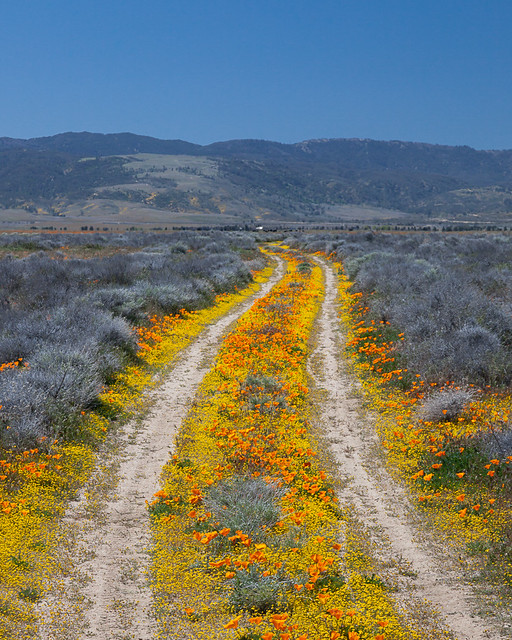
Road to Nowhere

Saturday, March 12, 2016

Death Valley "Super Bloom" 2016: Best Wildflower Sites

Lower Warm Spring Canyon Road from miles 1 to 3 had declined slightly... to this! Still better than a "normal" year.

Last week I repeated and expanded the complete south to north traverse of Death Valley National Park that I had scouted in February.  How were the wildflowers holding up?  What were the best locations?  The Park has been issuing detailed reports, so let's use the March 2 and February 24 reports as a baseline, and I'll illustrate current conditions with my photos.
-----

Mile Marker 42, Badwater Road
March 2, 2016

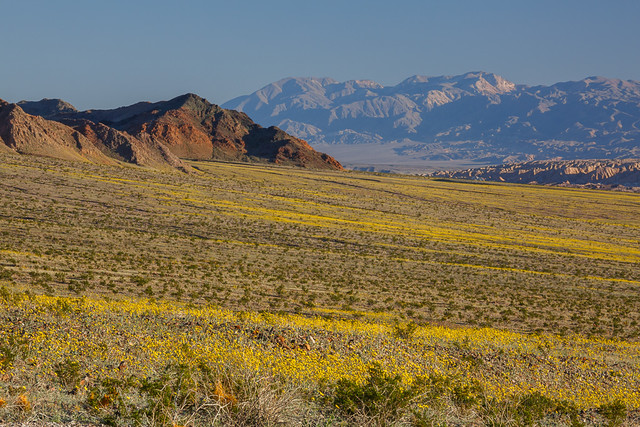
The bloom is definitely moving north and higher in altitude. Although there are still expansive fields of Desert Gold (Geraea canescens) along the Badwater Road, as well as carpets of Sand Verbena (Abronia villosa) from Mile Marker 42 to the end of the road, many of the other flowers in this area are past their peak.

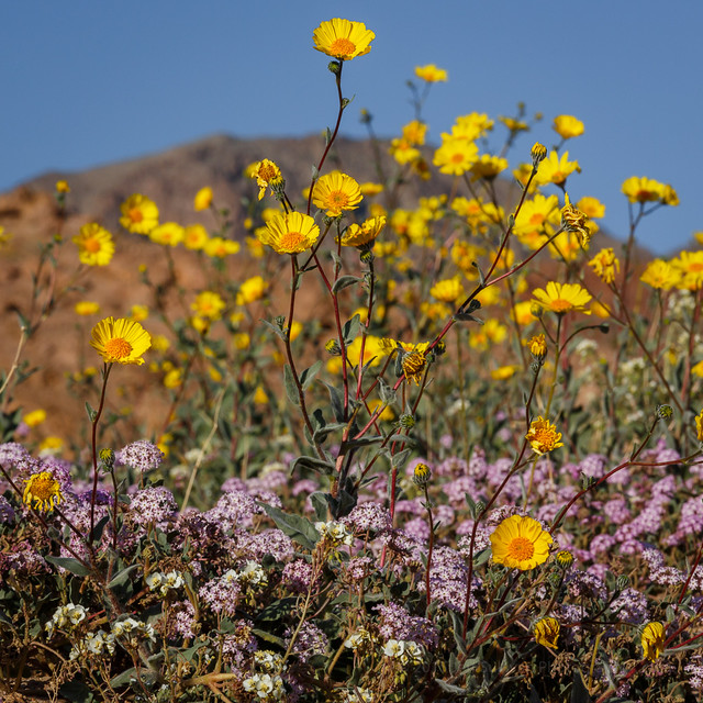
My pick of the week is Highway 190. Look for the cheerful Easter egg colors of bright yellow Golden Evening Primrose (Camissonia brevipes) and purple Notchleaf Phacelia (Phacelia crenulata) from Furnace Creek to the East Park Entrance. There are pink carpets of Purple Mat (Nama demissum) in some sections. (I think this flower was misnamed!) The ethereal, floating blossoms of Gravel Ghost (Atrichoseris platyphylla) are growing thicker in this area than I've ever seen them before. Northwest of the Visitor Center, you will find the expansive fields of Desert Gold that Death Valley is famous for. All along the road, get out and look closer for more variety.

Beatty Cutoff
A nice little loop drive is to go up the Beatty Cutoff Road and down Mud Canyon, then back to Furnace Creek along Highway 190. Mud Canyon is looking fantastic, but the flowers are growing so thick there that there is nowhere to pull over. Use the wide shoulders on the Beatty Cutoff and wander a wash to look for variety.

You will find Phacelia, Golden Evening Primrose, Mohavea (Mohavea breviflora), Acton Encelia (Encelia actoni), and Broad-Flowered Gilia (Gilia latiflora) on the Scotty's Castle Road. Although there are a few flowers on the approaches to Towne Pass and in the Panamint Valley, those areas are not yet worth a special trip. If you have a high clearance vehicle, do a little botanizing in the mid-elevations of the Greenwater Valley to increase your species count. There are not a lot of flowers blooming here yet, but there are a lot of different species, flowers you will not find in the lower elevations.

Hole in the Wall (4WD road)
Best backcountry dirt road drives this week would be the Hole in the Wall Road and Echo Canyon Road. Color and diversity in both these places is fantastic. Titus Canyon has some Paintbrush (Castilleja augustifolia) and Lupine (Lupinus sp.) in the mid-elevations, and flowers are blooming in the lower reaches of the canyon, but it will still be a few weeks before the bloom really gets going here.
For hikers, Fall Canyon and Monarch Canyon are good bets.
Happy flower hunting!

Furnace Creek Wash
February 24, 2016

The bloom is moving North! Check out the great color combo of Golden Evening Primrose (Camissonia brevipes) and Notchleaf Phacelia (Phacelia crenulata) decorating Furnace Creek Wash from the East Entrance to the Furnace Creek Inn. Keep your eyes open in that stretch for expanses of Purple Mat (Nama demissum) and the rounded humps of Turtleback (Psathyrotes ramosissima). Get out of your car and take a stroll in the wash, and you may be amazed at the diversity. I was able to identify over a dozen species in a ten minute walk!

Along Highway 190 north from the Visitor Center to the Scotty's Castle Road, fields of Desert Gold (Geraea canescens) are starting to fill in the blanks. One new hotspot is the Beatty Cut-Off Road. The diversity in some places is nothing short of amazing. Try walking a wash between Mile Markers 2 and 4 to taste a bit of that diversity.If you are traveling to Ubehebe Crater or the Racetrack, the Scotty's Castle Road is adorned with the same gold and purple color scheme as the Furnace Creek Wash. Although there is not enough yet to warrant a special trip, look for expanses of Mohavia (Mohavea breviflora) , blooming Acton Encelia (Encelia actoni), and Broad Flowered Gilia (Gilia latiflora) in this stretch. Phacelia and Golden Evening Primrose are also brightening up the approaches on both sides of Towne Pass.

Badwater Road Mile Marker 30, looking back at 25
The Badwater Road is still the go-to destination for those huge expanses of endless flowers. The Brown-Eyed Evening Primroses (Camissonia claviformis) are starting to bolt due to hot temperatures and lack of rain, but the Desert Gold is still going strong, and the Gravel Ghost Atrichoseis platyphylla), Pebble Pincushion (Chaenactis carphoclinia), and Broad-Leaved Gilia (Aliciella latifolia) are just getting started. If you want those lower elevation flowers, though, you may want to come soon. I am amazed at how quickly the Phacelia and Desert Five Spot ( Erimalche rotundifolia) are working their way up their stems.

Harry Wade Road has some really nice things going on near the Amargosa River Crossing. As usual, get out of your car and walk a wash to see more varieties. Echo Canyon and Hole in the Wall should have some nice flowers. Check out the rock walls and see if you can find Death Valley Monkeyflower (Mimulus rupicola).

Greenwater Valley is REALLY green. Some flowers are starting to bloom there –I saw Fremont Phacelia (Phacelia Fremontii), Desert Dandelion (Malicothrix californica glabrata), Desert Gold Poppy (Eschscholtzia glyptosperma), Checker Fiddleneck (Amsinckia tessellate) , Blazing Star (Mentzelia sp.) and Globemallow ((Sphaeralcea ambigua) –but they are VERY few and far between still. In 2 weeks, this road will really pop.

Dante's View Road uphill from Greenwater Valley... in November!
For hikers, canyons are best for diversity. Fall Canyon is looking great, or try Willow and Sidewinder Canyons, or just wander up a likely wash.

Happy Flower Hunting!

-----

Overall the suggestions were great: accurate and with greater/longer relevance than most visitors may suspect.  By last week the intensity of the bloom had clearly declined down near Ashford Mill from my previous trip in February, but it was 1000X better than a normal year before, so if it had declined to "only" 900X as good, who cares? The opportunities were still tremendous, and well above average for Death Valley.

Alongside Badwater Road, nearly to Jubilee Pass
There's been a lot said about wind last Saturday night damaging the flowers, but again, I suspect that's relative to the mid-February conditions. We're just spoiled this year. I expect that there are plenty of wildflowers left compared to normal, and there will be plenty of exceptional pockets less affected by wind. Also, I bet that certain species such as sand verbena are designed to withstand wind (how the dunes they live in are formed). As I recall, the wind was coming from the south in the evening on Saturday, then from the north the next morning, so many canyons oriented east-west would be protected from that.

Spotted alongside CA-190 north of Furnace Creek
Anyone with a little experience with desert wildflowers and Death Valley should be able to successfully decode the puzzle and find the locations and species best under whatever conditions present themselves. Then again, with so many miles of wildflowers blooming, it's hard to go wrong, and you're bound to do well just driving through the areas highlighted on the Park's wildflower map. I found the scene to the right by the side of the road, simply driving from Furnace Creek to Beatty Junction.  So get out to Death Valley and find whatever compositions catch your eye and imagination!

For more photos, I've started a Death Valley 2016 album on my +Death Valley Workshops page, and a Death Valley iPhone 6S+ Photos album there as well.

Wednesday, February 24, 2016

The Almost Super Bloom in Death Valley

Reports are still coming in strong on the excellent wildflower bloom underway this month in Death Valley National Park. These photos are from my scouting trip through the park February 7-11.  
Desert Gold and Sand Verbena in Death Valley
Desert gold and sand verbena


As of February 9, some flowers were past prime, others were vigorous, others were just emerging.  Some rain fell a week later, which should extend the season for this year's already healthy crop.

Ashford Mill to Jubilee Pass
Looking from the Ashford Mill area toward Jubilee Pass
In spite of the hype in the media and on social media, the park is NOT calling it a "super bloom" yet, but in the recent YouTube video titled "Death Valley Exposed: Wildflowers - February 2016", park ranger Alan Van Valkenburg does imply that it has the potential, perhaps with additional rains: “If you get the chance to see a bloom in Death Valley, especially a super bloom, you should take the opportunity to see it because it could be a once in a lifetime opportunity.”

There was a less dense area of desert gold north of Furnace Creek, up to and through the Beatty Cutoff area. Most other areas were looking basically lifeless, even though they may have received a lot of rain. The timing of the rain may not have been early enough for the plants to be far along yet, and once they get going they do need additional rain to keep the growth going. Rain last week in mid-February might have helped extend the life of these areas, and the growth of others.

Overall the spring wildflowers in Death Valley are usually very sparse, and peak in March, so outside of the areas I just described, the season seemed normal: nothing much should be expected in early February. The initial bloom may or may not be followed by decent blooming elsewhere. We saw healthy growth in November in areas such as the narrow last portion of the Dantes Peak road, so we were expecting the adjacent Greenwater Valley to be going nuts when we returned in February. Instead, it looked even weaker than last year... not much going and much less promising than expected.

So in much of the park, as the initial strong bloom of desert gold fades, the situation may resemble a more normal year, where you can find wildflowers, but it requires some hunting and probably high clearance, if not 4WD.

Here are a few more photographs from my visit to supplement the ones I included in my recent trip report. I drove the park from Dumont Dunes all the way out the top at the town of Big Pine.


Desert gold extensive but thin looking north from the Salt Creek turnoff north of Furnace Creek


Not far from Ashford Mill, south of Badwater


The southern end of Harry Wade Road wasn't as productive as the north end and and the Ashford Mill area.  Many of the flowers were wilted from heat, and didn't look like they were going to last much longer, especially the brown-eyed primrose.


Fiats don't float!  Not in water, not in sand.
Unpaved roads in Death Valley are marked for high clearance or 4WD vehicles for a reason.


It's not all about the desert gold.  Look closely and you'll find dozens of species available.


Bear in mind, the park didn't just suddenly become only about wildflowers!


Miner's cabin

Monday, February 15, 2016

Spring Wildflower Conditions in Death Valley, February 2016

Desert gold and Brown-eyed evening primrose near Lower Warm Springs Road February 10

Lately there has been widespread talk about a potential "superbloom" in Death Valley in 2016, due to the current strong El Nino weather pattern affecting the West Coast.  I've been hoping for a particularly strong season, so I've scouted the park from top to bottom, November to February, to monitor what's growing where.  I approached from the south at Baker and drove through the park from south to north from February 7 - 11, entering on the high clearance Harry Wade Road near Little Dumont Dunes, crossing the Amargosa River, passing Badwater, Furnace Creek, the closed road to Scotty's Castle and exiting to the north through Joshua Flats on Big Pine Road. 
Death Valley's Ashford Mill, much better than 2015
To be clear, it is an above average bloom in that area, with dense areas of wildflowers in patches, with white brown-eyed primrose growing alongside roads and in some washes, and yellow golden evening primrose taking over in some rockier, slightly higher elevations. Purple sand verbena appears in low quantities in some sandy areas. In other areas desert gold is still the most common species, but with less dense blooming.
Many other areas of the park got a lot of rain at least once, but as we drove by Scotty's Castle for example, which suffered a flood of epic proportions, there were almost no signs of green growth. There were few signs up by Eureka Dunes either, although the area clearly received healthy rain. So areas like these either received rain late and are behind Ashford Mill in timing, on track for a bloom no sooner than late March to April or May, or they didn't get enough water after the original soaking to keep germinated plants growing in ample quantities.

Sparse but visible and welcome, near Beatty Cutoff
Thick patches, not continuous, but extending for miles


As recently reported, as of mid-February there is a very good bloom of yellow "desert gold" wildflowers near Ashford Mill, about an hour's drive south of Furnace Creek. It is better than last year's bloom there, which was much-hyped at the time, but frankly in my opinion, didn't match expectations once you arrived there. So take reports with a grain of salt. Some reports may be designed to drive park visitation, room stays and meals sold, photography workshop attendance, or in some cases wildly enthusiastic may come simply out of the media's tendency to hype anything and everything.

In the area north of Furnace Creek alongside the road (CA-190) the blooming is more widespread than last year, but so far less dense than the best locations last year. While the Desert Gold often had multiple branches and blooms in the Ashford Mill area further south, it's less tall and often has only one stalk with a single flower. From the beginning of Artist Drive looking south towards Badwater you can see desert gold, but the density is lower than in past years. There is a sparse bloom near Saratoga Springs but the flowers there were already showing signs of heat stress early last week, and they get more dense further north alongside Harry Wade Road towards Ashford Mill. There's little to nothing happening from Shoshone through Tecopa to Baker alongside CA-127. There were no obvious signs of growth north of Scottys Castle alongside Big Pine Road. Strong initial growth of plants alongside the road to Dante's View apparent back in November has not been followed by more widespread growth just down the hill at Greenwater Valley Road.

So in spite of a sufficient rainfall in many places, we have a normal situation in the broken and sporadic nature of the rainfall in the park, and the timing of follow-on rain events can further affect the health of any bloom that does come.  So while it's an above average year in many areas, it'll still be very helpful to know where to look in this massive park.  Being prepared to reach the bloom locations will be particularly important given that the park only had 700 miles of roads, 2/3 of which are unpaved.  High clearance can be very useful in Death Valley National Park, and 4WD is required to reach some of the better locations. This will be particularly true as the blooming zones move up in elevation in March and April.


So bottom line, the Ashford Mill area is worth a visit if you can get to the park now.  Enjoy generally above average conditions from there through Salt Creek, but don't expect carpets of flowers.  Other areas could see more growth later, especially if there is more rain to give plants just getting started out a boost, but with an average of only 1.93" falling near Furnace Creek in a year, that's not something we can count on, so we may be seeing peak conditions in the most-visited, lower elevations in the park.

I'll be conducting a photography workshop in Death Valley National Park from March 1 - 6, 2016.  I like to offer a more adventurous workshop to show participants many of the unique locations I've discovered while exploring the park dozens of times over the past 12 years, and while researching locations to refer people to when I started writing my "Photographing California - South" guidebook in 2010.  I've found many new locations since the editorial deadline for the Death Valley chapter of that book, so now I'm working on a dedicated Death Valley guide as well.  We may take short hikes up up to 1.5 mile each way, so figure we could walk about 4-5 miles in a day.

For more information on the workshop, see the Death Valley workshop page on my blog: http://www.jeffsullivanphotography.com/blog/death-valley-photography-workshop-2013/


Sand Verbena and Desert Gold Near Ashford Mill, February 9, 2016

Sunday, May 18, 2008

Chasing Moonbows in Yosemite Valley at Night

Several times per year the moon is bright enough and at the right angle to create a night rainbow, a "moonbow", in the mist created by Lower Yosemite Falls.  Many people think that this phenomenon can only be seen and photographed from the bridge below the falls.  While that is the most common place for people to gather and photograph the moonbows, you can see moonbows in waterfall mist whenever the angles are right, so it can pay off to explore other shooting positions.  Even with Lower Yosemite Falls I often find moonbows in the waterfall's mist as I hike in towards the bridge.  Give it a try once or twice as you hike in and  and as you hike out.


As a starting point for predicting the best times to catch a moonbow in Yosemite, Don Olson of Texas State University has calculated the best times to look for a moonbow from the bridge below Lower Yosemite Falls:
http://uweb.txstate.edu/~do01/
If you go to the bridge to photograph the moonbows, please don't use headlamps, as they throw light uncontrollably all over the other photographers' shots.  And red lights are the worst, the most inconsiderate for you to use... very difficult to edit out of shots later.  This isn't astronomy, you're not in a darkroom.  Please have the simple courtesy to leave the red lights at home.  For seeing your camera controls without destroying your night vision, hold your (dimmed) phone display on top of your camera, facing back at yourself.  Any light of any kind that you sine back at the front of your camera, to see if there is water on the filter for example, will probably appear in the shot of the people next to you.
You can also catch the North Star directly at the top of Yosemite Falls, with the Big Dipper above.  It you have enough patience you can shoot a star trails sequence here, but you'll probably also catch a lot of flashlights and headlamps as people hike in and out.  Note that moonbows are most typically seen under a nearly-full moon, so if you simply give your eyes a few minutes to adjust, you probably don't need a headlamp or flashlight to walk in and out on this paved path.  You'll probably see much more with night-adjusted vision and no light than you would with poorly adjusted vision and a tiny spot of light.  That can even be true under the light of the stars only if you're in an open enough area for the starlight to shine on the ground around you.


I also found a moonbow in Lower Yosemite Falls (click to enlarge) from the Illouette Falls viewpoint and Four Mile Trail trail head a couple of days earlier at midnight.  No crowds and foreground-destroying red lights here!  There's virtually no limit to where you can shoot Yosemite moonbows from, if you do a little searching.


There were also many reflection opportunities in vernal pools in Cook's Meadow.  This pool does not exist or it is too low after winters with too little snow, such as 2014.
I hope that I've provided some useful information on Yosemite's moonbows so you can pursue some interesting and unique shots.

If you'd like to join me in Yosemite sometime, you can find my Yosemite photography workshop schedule on a dedicated page accessible from the top page of this blog (I'm currently working out the dates for 2014, so you might have to check back or get on my mailing list to hear when they're released): 
http://www.jeffsullivanphotography.com/blog/yosemite-national-park-photography-workshops/

Saturday, February 23, 2008

Spring Wildflowers in California


Here are some field trip ideas, with links to sites where you can check for updates on wildflower timing and intensity this year:

Joshua Tree National Park:
"Wildflower season usually begins with the large, cream-colored blooms of the Joshua trees in late February, followed by colorful annuals at the lower elevations around the south boundary of the park. Sometime in March, the bloom will follow rising temperatures into the higher elevations of the park. Cacti usually wait until April or May to produce their bright, waxy flowers."

Mojave Desert National Preserve:
"In general, spring flowering begins as temperatures rise -- first at lower elevations in February and later at higher elevations in March and April. On mountain tops above 5,000 feet blooms are as late as June. Some believe that spectacular desert blooms occur on an average about once every twenty years and others say that an ideal year comes once every three or four decades."

Added attraction:
"At about 600 feet in height, Kelso Dunes in Mojave National Preserve are the third tallest in North America. "

Daffodill Hill, Amador County:
"Each spring, from mid-March through mid-April, Daffodil Hill explodes with thousands of blooms, attracting visitors from around the world. It is estimated that today, Daffodil Hill is carpeted with over 300,000 bulbs. Daffodil Hill is in a beautiful alpine setting at an elevation of over 3,000 feet. With pine trees, an old barn, wagon wheels, and rusting mining equipment and farming tools, it appeals to anyone with a love of nature. Flowers are everywhere, with pea-fowl, chickens, pigeons and lambs making themselves at home."

Anza Borrego Desert State Park, San Diego County:
"Park botanists estimate the peak of the bloom this year will be the first two weeks of March"

Antelope Valley California Poppy Reserve:
This State Reserve, nestled in the Antelope Buttes 15 miles west of Lancaster, California, is located on California's most consistent poppy-bearing land. Other wildflowers: owl's clover, lupine, goldfield, cream cups, and coreopsis, to name a few, share the desert grassland to produce a mosaic of color and fragrance each spring. As unpredictable as nature - the intensity and duration of the wildflower bloom varies yearly.

Death Valley National Park:
"The peak bloom is variable depending on temperatures and rainfall, but can be expected around mid to late March."

A good general site to check is:
Desert USA's Desert Wildflower Watch